South Avenue Safe Streets
 Let us know what to prioritize for the Safe Streets and Roads for All grant for South Avenue.
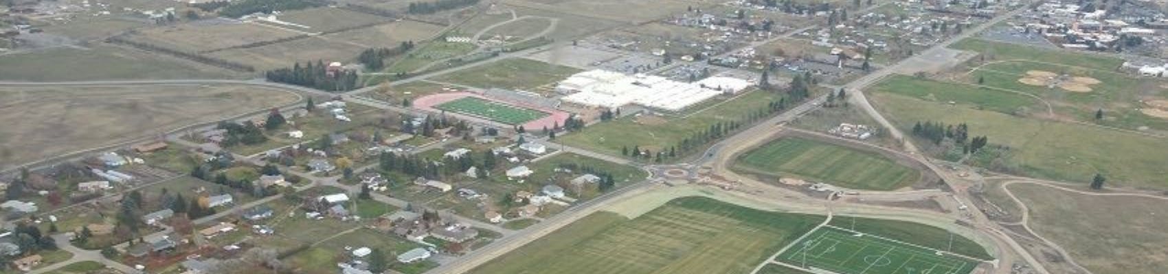
Missoula County and the City of Missoula received a federal Safe Streets and Roads for All grant earlier this year that will fund much-needed safety improvements on South Avenue between Reserve Street and Clements Road and on Clements Road between South and North avenues.
South Avenue Safe Streets for All Project Update: Sept. 8, 2025
Missoula City and County are making progress on the South Avenue Safe Streets for All Project, a multi-year effort to improve safety, accessibility, and mobility for everyone traveling along South Avenue and Clements Road. The project will reconstruct the roadway from Reserve Street to Clements Road, as well as Clements Road from South Avenue to North Avenue.
Planned improvements include new sidewalks, bike lanes, and trail connections, along with added turn lanes, curb and gutter, upgraded crosswalks, and improved bus stop facilities. The project also incorporates enhanced lighting, stormwater drainage, landscaping, and utility relocations. To address safety concerns at one of the busiest intersections in the corridor, a mini-roundabout will be constructed at South Avenue and Clements Road.
These upgrades are designed to benefit all users—pedestrians, bicyclists, drivers, and transit riders—while creating better access to Fort Missoula Regional Park, Big Sky High School, the Community Medical Center, and nearby neighborhoods and businesses. By applying the federal Safe System Approach, the project aims to reduce serious crashes, improve ADA accessibility, and encourage more walking, biking, and transit use.
The $12.56 million project is funded through a federal Safe Streets for All grant, which covers 80 percent of the cost. The remaining 20 percent comes from City and County local matches. Engineering work is being led by WGM Group, with construction anticipated in 2027 and 2028 following right-of-way acquisition and final design.
Who's Listening
-

Phone 406-258-4818 -
Phone 406-552-6678
Documents
-
 36th to Reserve Avenue.pdf (16.7 MB) (pdf)
-
Clements to 36th Avenue.pdf (16.8 MB) (pdf)
-
South Ave Reconstruction - Typical Sections.pdf (514 KB) (pdf)
-
South Avenue Safe Streets For All Goals.pdf (1.6 MB) (pdf)
-
South Avenue Safe Streets For All Timeline.pdf (1.36 MB) (pdf)
-
Street Improvements Near Target Range School.pdf (5.03 MB) (pdf)

My primary areas of concern are on Clements between North to South Aves and on South Ave from Gunsight to Big Sky High school, basically the areas nearest the schools. I'd like to see raised or protected sidewalks/walkways to be contiguous on both stretches. I'd like the corner of Clements and South to have a 3 way stop or strobe flashers for pedestrian crossings. I also think rumble strips that run perpendicular to the road starting 100 yards from the school on both Clements and South could be very effective to slowing traffic. I'd also like to see a safe crossing from the Trough/Old Dairy to the sidewalk/walkway on Clements.
My main concern is around traffic in and out of the school and around the Olde Dairy on Clements Ave. Ideally a roundabout would keep traffic flowing during busy times and slow it down (as it does around Big Sky High School). I am also in favor of a pedestrian crosswalk (flashing lights) and speed hump (not bump) on Clements across from the Olde Dairy to improve the safety of students crossing after school.
Improvements to the separated SUP between fmrp and target range school are needed. Degradation of this trail makes it very uncomfortable to bike and it will continue to get worse over time without a full replacement of the pavement. A better connection to and in front ofTarget range school is critically needed, it is unsafe and confusing as is today. Traffic (especially at night and on weekends) is very fast and south ave has become a drag racing strip because it is wide and straight. Serious traffic calming is needed such as narrower lanes, round abouts at intersections, and boulevards and street trees. Just eliminating the shoulders and adding a center turn lane will not have this effect. The backing up of traffic due to left turning vehicles is not an issue except near commmunity hospital.
Forgot to add. Maybe make it so people who are on South CANNOT turn left onto Old Fort Toad. Too many driveways and accidents that can result in the loss of life.
How about this Missoula county and city. Why don’t you work on the current infrastructure before we look at a bridge to essentially no where. And the fact the money isn’t guaranteed and that you will be coming to the residents with your hands out asking for more money. After basically taxing us out you might want to reconsider this project. Maybe just turn lanes and leave it at that. Just maybe think about how you want to proceed with this before coming to the public, just maybe.
There is a need for left turn lanes between Reserve and Clements. There is no need for sidewalks on both the north and south sides of the road. Connect and maintain the walking paths on the south side of South Avenue West. Clearly delineate crosswalks on Clements and South Avenue West.
NO round about on South Avenue! To do a round about anywhere near the school would make the crossing more hazardous for children and adults, during school hours and after school hours and on weekends when there would be no crossing guards. Yes, there would still be the need for crossing guards (probably a larger number than now).
South Avenue West needs pavement work. The potholes are dangerous for any vehicles traveling east or west.
Drop the dream, ultimate perfection concept currently envisioned in the proposal. Cut back on the expenditure, do only what's necessary for the safety of all.
The proposed changes to S Ave are clearly an attempt to secure and spend federal and local monies, just because they might be available. This is irresponsible overstepping under the guise of safety. Nothing is done for free. The taxpayers pay.
The traffic patterns and pedestrian usage between Reserve and Clements do not support a project of this magnitude. This is government bloating, looking for projects to latch onto in order to give their agency and position purpose.
Being a resident of the area I see the morning, noon and evening vehicle and pedestrian traffic. It does not require a scope or expenditure as the public works group is proposing.
I suggest the city or county invest in simple but effective improvements. Install reflective tape lane markers in lieu of paint. Install pedestrian activated flashers at crosswalk locations. Install streetlights at crosswalk locations. Install additional crosswalks at Big Sky and Target Range schools. Utilize / extend / connect / maintain the pedestrian pathway that already exists and was invested in. Make the intersection at Clements and S Ave a three way stop. Install signs that flash driver speed.
Regarding speed….All of S Ave W is posted at 30mph, except the stretch between Reserve and Gun Sight. Why isn’t the stretch in question posted at 30 mph like the rest of the road? Heck, why not drop it to 25mph?
Bottom line, there are better, more fiscally responsible improvements available. Our local public works team should pursue these options and drop the mega millions project that is driven by ego, competition, justification of jobs and bragging rights.
Be well, Missoula!
I am excited about the intent of these improvements.
The changes on Clements would be a welcome relief. I shudder seeing schoolchildren walking right next to a 35MPH road with no curb and no separation from wandering vehicles. This feeling is double in the winter when the bow of the road sends ice and sliding cars directly into the path. The measly plastic pylons offer no protection, and have ongoing maintenance of being cycled out as the seasons change.
It would be nice to have everything, but property taxes go higher and higher. With the surge in home prices, the next property assessments are going to be brutal, and this would be another stone on the burden. If I were working on this project, I'd want to know: Where are the 113 crashes on this corridor? What kind of crashes were they? What's the minimum necessary to prevent those accidents and improve traffic flow? I'd have to guess most of the accidents occur between reserve and 31st, so those improvements seem proper. Special attention should be paid attention to area right next to reserve, and the turning traffic at 27th and Old Fort Road. The turning lane will be great for the accordion westbound traffic caused by left turns on to old fort road.
Pedestrian safety seems like it would be particularly important at Target Range School, and between clements and 31s. I'm not convinced the current proposal affords much additional safety to those attempting to cross to the shared use path. I would love to see strobe flashers at the major crossings so that children going to school don't have to contend with drivers. Keep in mind that a good portion of the year, kids will be going to school in the dark or at dawn, when visibility is difficult. Also, many of those vehicles are exceeding the 35MPH speed limit, making so stopping after late sighting a difficult thing to do.
Thanks for the work on this, I hope it moves forward in a way that maximizes value and minimizes expense.
Hello planners: a major oversight I see in these documents is that actions at South Ave. are inseparable from what happens with the Maclay Bridge. The one lane bridge is registered as "historical" and the location is also a traditional river access site for the enjoyment by the community of the Bitterroot River. However, current parking controls there by exclusive neighbors have made it virtually impossible to park any motor vehicles nearby that bridge or river beach, and your design of South Ave bridge shows no provision for river access or nearby parking there either. One of the treasures of Missoula is access to our rivers, and ignoring public access in this reach of the river in unacceptable. You need to recognize in official planning that South Ave. actions are inseparable from Maclay Bridge actions, and that public access to the river is being neglected at each site.
Just because a public agency/agencies *can* get some Federal money to >>PARTIALLY<< pay for something, doesn't mean it has to be done. If the entire project was funded, 100%, from non-local dollars, then fine... have fun. But that's not really. First: It's not clear if adequate ROW exists along the entire corridor. Second: Widening/improving South Ave. west of Big Sky High, or possibly west of 36th Ave. is entirely unnecessary. Third: Re-doing the multimodal trail adjacent to Clements would be nice... but the County only put that in a few years ago, and maybe could have done a separated grade then? How do we no recover those wasted tax dollars? Fourth: Sitting in meetings years ago, it had been decided that the City was responsible for upgrading South Ave. to city standards along the entire route of Fort Missoula Regional Park. That clearly hasn't happened. Fifth: Why haven't there been safer bike/ped crossings (across South Ave.) put in yet? Simply putting those in would solve a lot of safety issues with very little effort. Sixth, and it's a big one... since when the South Ave. Bridge become a done deal? The County Commissioners have been adamant - and campaigned on this - that the bridge would not happen. The only people that seem to want it are property owners next to Maclay Bridge, and Public Works leadership. You don't have easements, you don't have rights-of-way, and it's an entirely unnecessary project.
Hello. I believe a couple situations need your attention; first South Avenue traffic flow. During commuting hours, South Ave has a diurnal directional commuter traffic flow that creates a limited access street for traffic seeking turning onto South from south bound secondary feeder streets. Only one traffic flow control that puts any gap in traffic flow is the traffic signal at South Avenue & South Reserve Street. Maybe consider another traffic control signal at South Ave & Clements Road. Second, access to Big Sky Horse Park needs additional considerations. For example, this traffic includes towing vehicles and trailers. Some are off tracking fifth wheel trailers, with curve widening requirements. Further, an alternative Park entrance intersecting with Tower Road might be considered?
Please consider a 3 way stop at Clements and South Ave W (or flashing lights which could be used only during school zone times.) I was among 9 vehicles waiting to make a left turn (East) from Clements onto South Ave W at 8 am yesterday. Stopping traffic at this location would also benefit the neighborhoods on the North side of South Ave W. The majority of these northside streets are dead ends. The round-about at the Regional Park is the only traffic flow control on South Ave W. from Reserve St to the end of South. Thank you for your consideration.
Some of this plan is needed and would be a welcome improvement to the neighborhood. Reserve to 31st could use a turn lane and improvements to the south shared path so it is continuous is needed. With this large shared path on the South side there is no need for a bike path on the North of any of this project and this would reduce the encroachment on property along this whole stretch. A side walk on the north side is only needed from Reserve to the roundabout on Tower. I also have concern on the snow removal in this area once the improvements happen. Currently there is a plow and it only does 1 pass west and 1 pass east so I am assuming that the snow would be pushed into the turn lane which then makes it unsafe for about 5 months of the year. I have seen this process in the University District and they don't plow away the berm so there is ability to turn right or left out of an intersection with out the possibility of high centering your vehicle. There is also a Mountain Line Stop right on South Ave that is not on this map for improvement, I suggest that it is moved to into the Regional Park because there is designated "bus" pullouts but are never used by the Mountain Line.
Please follow through with the sidewalk on the North side of the street. There is no safe way to go for a person in a wheelchair. It would be used!
I attended the meeting at Target Range School. I am against any improvements to South ave. West of 36th ave. I believe that most of the traffic goes to the High School and the Regional Park.If any improvements are to be made a few pedestrian/bike activated flashing light crossings should be installed. The current design as presented at the meeting with a left turn center lane (suicide lane) with boulevard would be invasive and under utilized. I see the left hand turn lanes all over town misused as merge lanes and they are EXTREMELY dangerous..The path on the South side of South hardly gets much use now so one on the North side would be redundant.
I believe continuing the bike path on the East side of Clements would be a VERY sensible addition to our neighborhood. As far as any improvement West of Clements I am totally against any improvements and deem them to be unnecessary including the replacement and relocation of the bridge.
In conclusion I found the inclusion of the info about the bridge to be inane.It appeared as if it is a forgone conclusion which I believe is incorrect. With that in mind I see very little reason for much of the presented information to be applicable in the current situation with volume of existing traffic