Articles
-
Floodplain Development Permit No. 26-21
Share Floodplain Development Permit No. 26-21 on Facebook Share Floodplain Development Permit No. 26-21 on X (formerly Twitter) Share Floodplain Development Permit No. 26-21 on Linkedin Email Floodplain Development Permit No. 26-21 linkProject Description
The Missoula County Planning, Development and Sustainability Department (PDS) has received Floodplain Development Permit Application #26-21 from Andrew D. Sellars to build a new accessory structure in the floodplain.

The primary purpose of a Floodplain Development Permit is to promote public health, safety and general welfare, to minimize flood losses in areas subject to flood hazards, and to promote wise use of the floodplain.
Project Location
The property is located at 4375 US Highway 93 in the Bitterroot River floodplain. See location here.
The full application is available for review online or in the PDS office at 131 East Main St. in Missoula.
Please feel free to call 406-258-4657 or email floodplain@missoulacounty.us with any questions or to make an appointment to review the permit application.
Public Comment
Submit comments by 5 p.m. Friday, August 12, by using the comment tool below, emailing floodplain@missoulacounty.us or mailing to Planning, Development and Sustainability, Attn: Matt Heimel, Floodplain Administrator, 200 W. Broadway St., Missoula MT 59802.
Related Documents and Links
-
Floodplain Development Permit No. 26-20
Share Floodplain Development Permit No. 26-20 on Facebook Share Floodplain Development Permit No. 26-20 on X (formerly Twitter) Share Floodplain Development Permit No. 26-20 on Linkedin Email Floodplain Development Permit No. 26-20 linkProject Description
The Missoula County Planning, Development and Sustainability Department (PDS) has received Floodplain Development Permit Application #26-20 from Tollefson Properties LLC to build a utility enclosure for a pump that is part of a project to divert water from the Bitterroot River to Miller Creek.

The primary purpose of a Floodplain Development Permit is to promote public health, safety and general welfare, to minimize flood losses in areas subject to flood hazards, and to promote wise use of the floodplain.
Project Location
The property is located at 6225 Haugan Drive in the Bitterroot River floodplain, S14, T12N, R20W, Missoula County. See location here.
The full application is available for review online or in the PDS office at 131 East Main St. in Missoula.
Please feel free to call 406-258-4657 or email floodplain@missoulacounty.us with any questions or to make an appointment to review the permit application.
Public Comment
Submit comments by 5 p.m. Friday, August 12, by using the comment tool below, emailing floodplain@missoulacounty.us or mailing to Planning, Development and Sustainability, Attn: Matt Heimel, Floodplain Administrator, 200 W. Broadway St., Missoula MT 59802.
Related Documents and Links
-
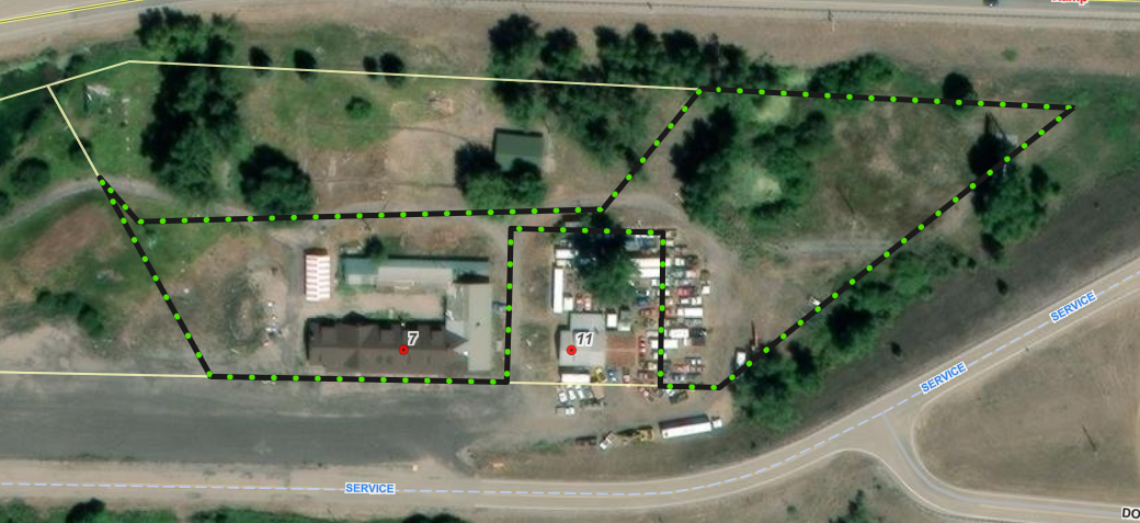
Floodplain Development Permit No. 26-24
Share Floodplain Development Permit No. 26-24 on Facebook Share Floodplain Development Permit No. 26-24 on X (formerly Twitter) Share Floodplain Development Permit No. 26-24 on Linkedin Email Floodplain Development Permit No. 26-24 linkProject Description
The Missoula County Planning, Development and Sustainability Department (PDS) has received Floodplain Development Permit Application #26-24 from Mari Houck of Five Valleys Land Trust to construct access improvements for an open space property.
The primary purpose of a Floodplain Development Permit is to promote public health, safety and general welfare, to minimize flood losses in areas subject to flood hazards, and to promote wise use of the floodplain.
Project Location
The site is located east of 29 Rock Creek Road in the Clark Fork River floodway: S7, T11N, R16W, Missoula County. See location here.
The full application is available for review online or in the PDS office at 131 East Main St. in Missoula.
Please feel free to call 406-258-4657 or email floodplain@missoulacounty.us with any questions or to make an appointment to review the permit application.
Public Comment
Submit comments by 5 p.m. Friday, July 24, by using the comment tool below, emailing floodplain@missoulacounty.us or mailing to Planning, Development and Sustainability, Attn: Matt Heimel, Floodplain Administrator, 200 W. Broadway St., Missoula MT 59802.
Related Documents and Links
-
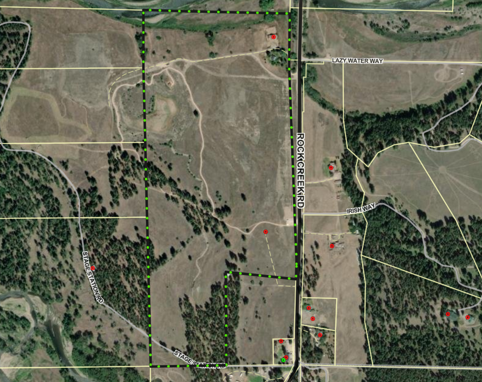
Floodplain Development Permit No. 26-22
Share Floodplain Development Permit No. 26-22 on Facebook Share Floodplain Development Permit No. 26-22 on X (formerly Twitter) Share Floodplain Development Permit No. 26-22 on Linkedin Email Floodplain Development Permit No. 26-22 linkProject Description
The Missoula County Planning, Development and Sustainability Department (PDS) has received Floodplain Development Permit Application #26-22 from Nicholas Caras to make improvements to an existing commercial building.
The primary purpose of a Floodplain Development Permit is to promote public health, safety and general welfare, to minimize flood losses in areas subject to flood hazards, and to promote wise use of the floodplain.
Project Location
The site is located at 7 Rock Creek Road in the Clark Fork River floodplain: Parcel C of COS 1041, S12, T11N, R17W, Missoula County. See location here.
The full application is available for review online or in the PDS office at 131 East Main St. in Missoula.
Please feel free to call 406-258-4657 or email floodplain@missoulacounty.us with any questions or to make an appointment to review the permit application.
Public Comment
Submit comments by 5 p.m. Friday, July 24, by using the comment tool below, emailing floodplain@missoulacounty.us or mailing to Planning, Development and Sustainability, Attn: Matt Heimel, Floodplain Administrator, 200 W. Broadway St., Missoula MT 59802.
Related Documents and Links
-
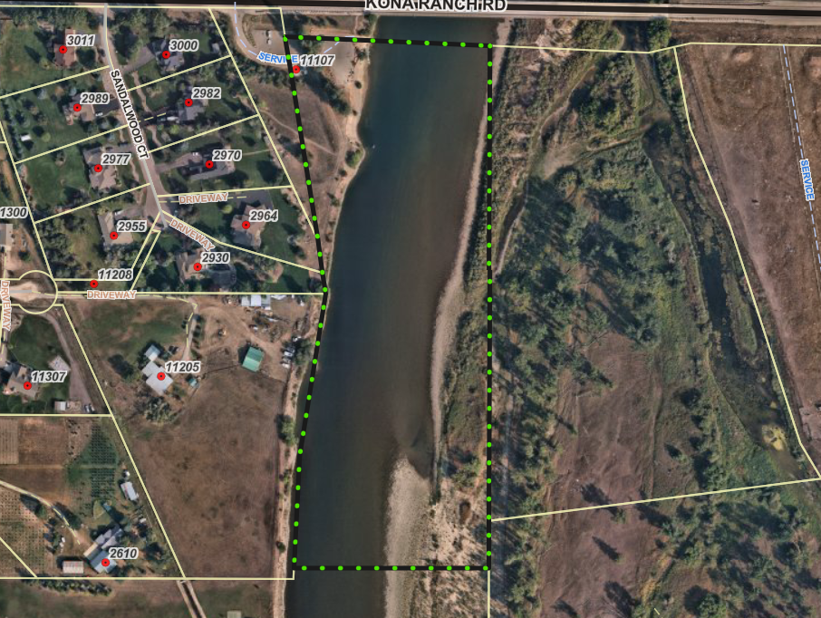
Floodplain Development Permit No. 26-19
Share Floodplain Development Permit No. 26-19 on Facebook Share Floodplain Development Permit No. 26-19 on X (formerly Twitter) Share Floodplain Development Permit No. 26-19 on Linkedin Email Floodplain Development Permit No. 26-19 linkProject Description
The Missoula County Planning, Development and Sustainability Department (PDS) has received Floodplain Development Permit Application #26-19 from the Montana Department of Fish, Wildlife and Parks to stabilize a section of streambank adjacent to Kona Bridge Fishing Access site.
The primary purpose of a Floodplain Development Permit is to promote public health, safety and general welfare, to minimize flood losses in areas subject to flood hazards, and to promote wise use of the floodplain.
Project Location
The site is located at 11107 Kona Ranch Road in the Clark Fork River floodplain: S8, T13N, R20W, Missoula County. See location here.
The full application is available for review online or in the PDS office at 131 East Main St. in Missoula.
Please feel free to call 406-258-4657 or email floodplain@missoulacounty.us with any questions or to make an appointment to review the permit application.
Public Comment
Submit comments by 5 p.m. Friday, July 24, by using the comment tool below, emailing floodplain@missoulacounty.us or mailing to Planning, Development, & Sustainability, Attn: Matt Heimel, Floodplain Administrator, 200 W. Broadway St., Missoula MT 59802.
Related Documents and Links
-
Floodplain Development Permit No. 26-18
Share Floodplain Development Permit No. 26-18 on Facebook Share Floodplain Development Permit No. 26-18 on X (formerly Twitter) Share Floodplain Development Permit No. 26-18 on Linkedin Email Floodplain Development Permit No. 26-18 linkProject Description
The Missoula County Planning, Development, & Sustainability Department (PDS) has received Floodplain Development Permit Application #26-18 from the Montana Department of Fish, Wildlife and Parks to stabilize a section of streambank that is adjacent to the Kelly Island Fishing Access site.
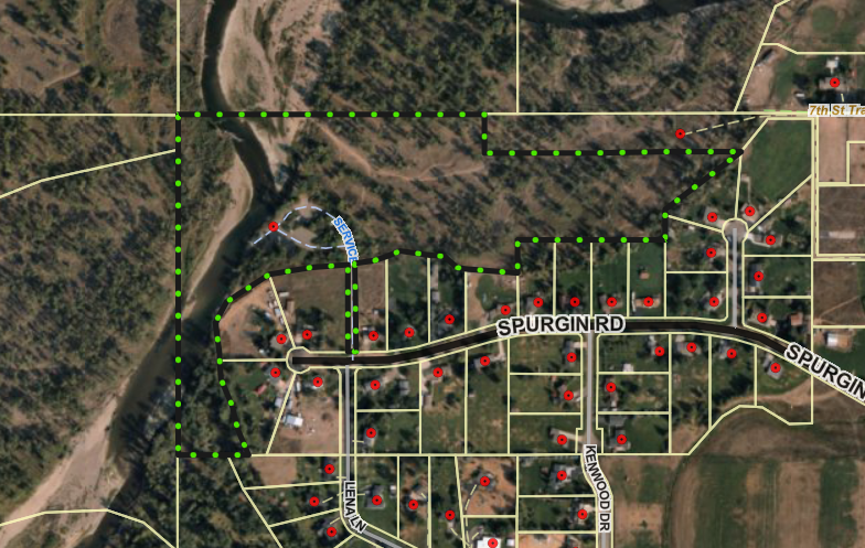
The primary purpose of a Floodplain Development Permit is to promote the public health, safety, and general welfare, to minimize flood losses in areas subject to flood hazards, and to promote wise use of the floodplain.
Project Location
The site is located at 4854 Spurgin Road in the Clark Fork River floodplain: S26, T13N, R20W, Missoula County. See location here.
The full application is available for review online or in the PDS office at 131 East Main St. in Missoula.
Please feel free to call 406-258-4657 or email floodplain@missoulacounty.us with any questions or to make an appointment to review the permit application.
Public Comment
Submit comments by 5 p.m. Friday, July 24, by using the comment tool below, emailing floodplain@missoulacounty.us or mailing to Planning, Development, & Sustainability, Attn: Matt Heimel, Floodplain Administrator, 200 W. Broadway St., Missoula MT 59802.
Related Documents and Links
-
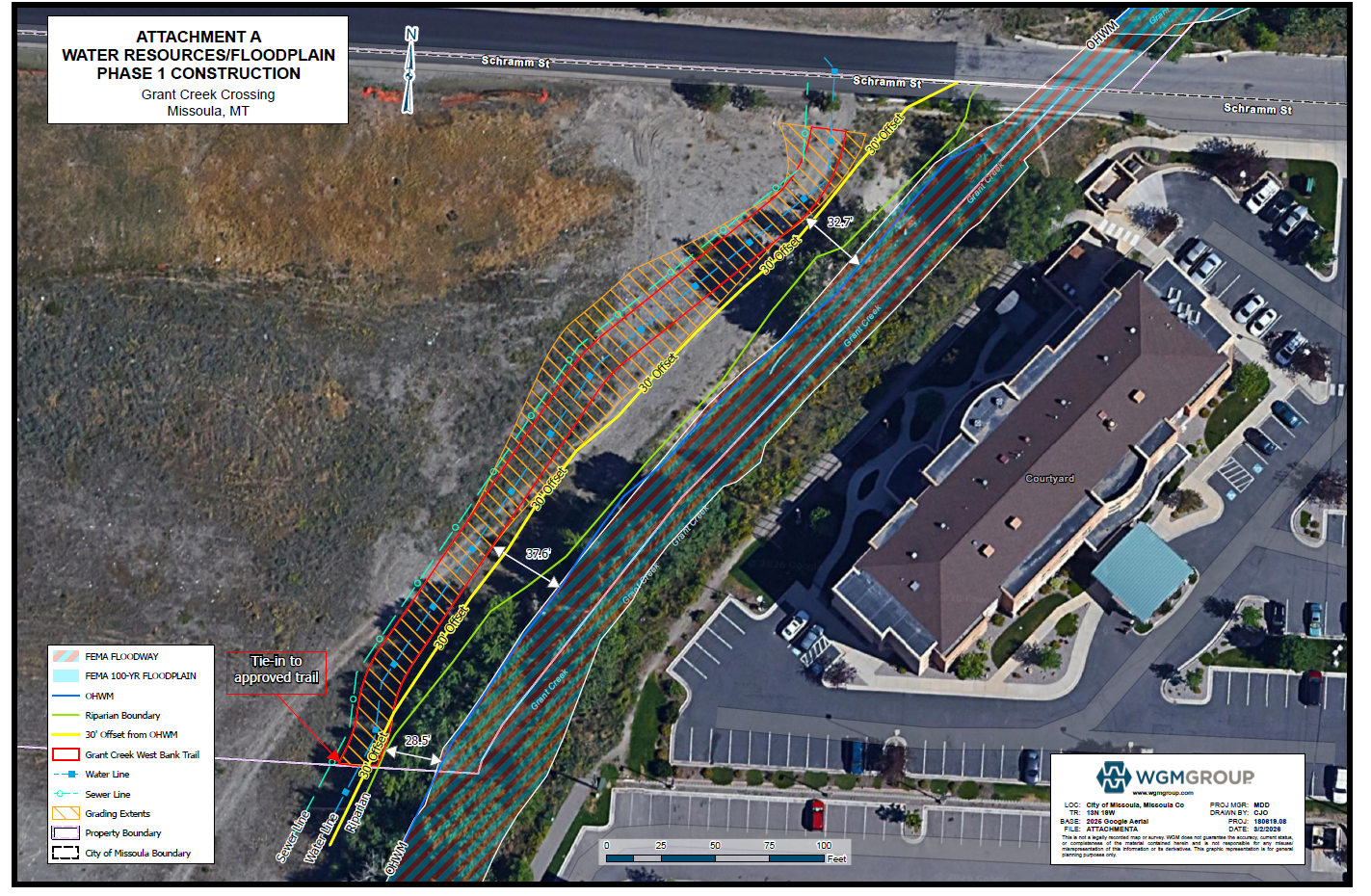
Floodplain Development No. 26-12
Share Floodplain Development No. 26-12 on Facebook Share Floodplain Development No. 26-12 on X (formerly Twitter) Share Floodplain Development No. 26-12 on Linkedin Email Floodplain Development No. 26-12 linkProject Description
The Missoula County Planning, Development and Sustainability Department (PDS) has received a Floodplain Development Permit #26-12 from Grant Creek Crossing – Missoula LLC for reconstruction of Schramm Street in the Grant Creek regulated flood hazard area.
The site is located at the Schramm Street crossing over Grant Creek, about 725 feet of Reserve Street: Tract 3A-1B COS 7031, S05, T13N, R19W in Missoula County.
What is a floodplain development permit?
The primary purpose of a floodplain development permit is to promote public health, safety and general welfare, to minimize flood losses in areas subject to flood hazards, and to promote wise use of the floodplain.
Public Comment
Submit public comment by 5 p.m., Monday, April 6, through the following three ways.
- Use the comment tool below. You must be registered on Missoula County Voice
- Email floodplain@missoulacounty.us
- Mail to Planning, Development and Sustainability
- Attn: Matt Heimel, Floodplain Administrator, 200 W. Broadway St., Missoula, MT 59802
Questions or want to make an appointment?
Please feel free to call 406-258-4647 or email floodplain@missoulacounty.us with any questions or to make an appointment to review the permit application.
Important Documents and Links
Floodplain and Shoreline Administration Webpage
Physical applications are available in the PDS office at 127 E. Main St., Suite 2, in downtown Missoula
This permit is subject to approval by the floodplain administrator and does not go before the county commissioners.
-
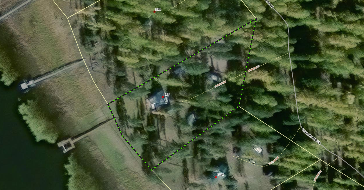
Floodplain Development No. 26-08 (Seeley Lake)
Share Floodplain Development No. 26-08 (Seeley Lake) on Facebook Share Floodplain Development No. 26-08 (Seeley Lake) on X (formerly Twitter) Share Floodplain Development No. 26-08 (Seeley Lake) on Linkedin Email Floodplain Development No. 26-08 (Seeley Lake) linkProject Description
The Missoula County Planning, Development and Sustainability Department (PDS) has received a Floodplain Development Permit Application #26-08 from Amee Tafoya for reconstruction of a cabin in the Clearwater River regulated flood hazard area.
The site is located at 975 Leaning Pine Drive on state-leased land: Parcel: 13, COS 4875, S)4, T16N, R15W in Missoula County.
What is a floodplain permit?
The primary purpose of a Floodplain Development Permit is to promote public health, safety, and general welfare, to minimize flood losses in areas subject to flood hazards, and to promote wise use of the floodplain.
Public Comment
Submit public comment by 5 p.m., Monday, April 6, through the following three ways.
- Use the comment tool below. You must be registered on Missoula County Voice
- Email floodplain@missoulacounty.us
- Mail to Planning, Development and Sustainability
- Attn: Matt Heimel, Floodplain Administrator, 200 W. Broadway St., Missoula, MT 59802
Questions or want to make an appointment?
Please feel free to call 406-258-4647 or email floodplain@missoulacounty.us with any questions or to make an appointment to review the permit application.
Important Documents and Links
Floodplain Permit Application and Value Estimates – 8.28.25
Floodplain Permit Application and Values Estimates – 9.18.25
Floodplain and Shoreline Administration Webpage
Physical applications are available in the PDS office at 127 E. Main St., Suite 2 in downtown Missoula
This permit is subject to approval by the floodplain administrator and does not go before the county commissioners.
-
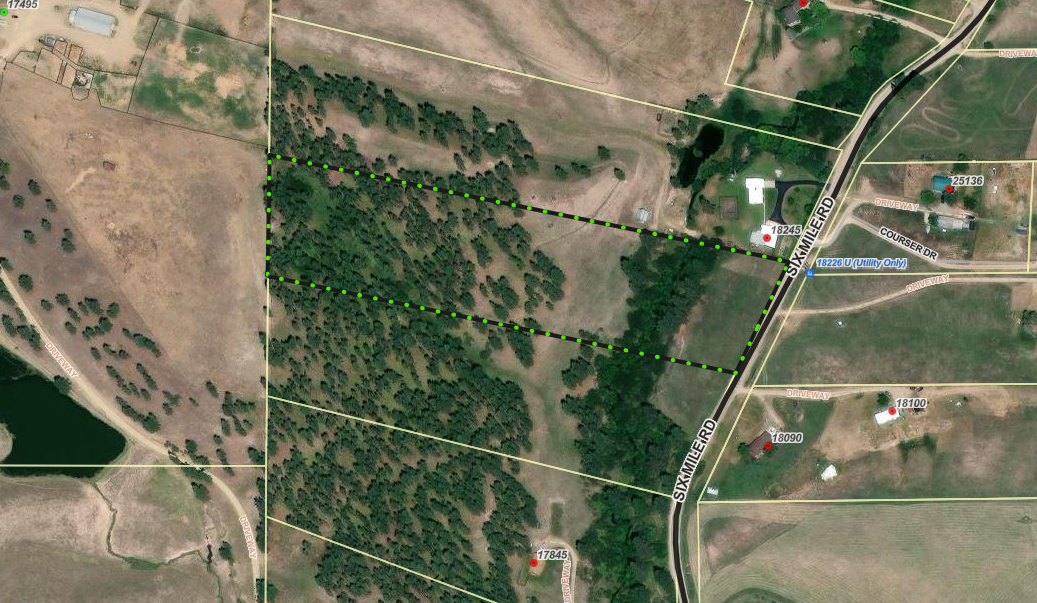
Floodplain Development No. 26-05 (Frenchtown)
Share Floodplain Development No. 26-05 (Frenchtown) on Facebook Share Floodplain Development No. 26-05 (Frenchtown) on X (formerly Twitter) Share Floodplain Development No. 26-05 (Frenchtown) on Linkedin Email Floodplain Development No. 26-05 (Frenchtown) linkProject Description
The Missoula County Planning, Development & Sustainability Department (PDS) has received a Floodplain Development Permit Application #26-05 from George Neumunz for construction of a stream crossing in the Sixmile Creek regulated flood hazard area.
The site is located on the west side of the Sixmile Road: Lot 21 of Six Mile Timber Tracts #2, S23, T15N, R22W, Missoula County.
What is a floodplain development permit?
The primary purpose of the floodplain development permit is to promote the public health, safety, and general welfare, to minimize flood losses in areas subject to flood hazards, and to promote wise use of the floodplain.
Public Comment:
Submit public comment by 5 p.m., Monday, April 6 through the following three ways.
- Use the comment tool below. You must be registered on Missoula County Voice
- Email floodplain@missoulacounty.us
- Mail to Planning, Development, & Sustainability
- Attn: Matt Heimel, Floodplain Administrator, 200 W. Broadway St., Missoula, MT 59802
Questions or want to make an appointment?
Please feel free to call 406-258-4647 or email floodplain@missoulacounty.us with any questions or to make an appointment to review the permit application.
Important Documents and Links:
Supplemental and Revised Packet
Floodplain and Shoreline Administration Webpage
Physical applications are available in the PDS office at 127 E. Main St., Suite 2 in downtown Missoula
This permit is subject to approval by the floodplain administrator and does not go before the county commissioners.
-
Floodplain Development No. 26-03
Share Floodplain Development No. 26-03 on Facebook Share Floodplain Development No. 26-03 on X (formerly Twitter) Share Floodplain Development No. 26-03 on Linkedin Email Floodplain Development No. 26-03 linkProject Description
The Missoula County Planning, Development, & Sustainability Department (PDS) has received Floodplain Development Permit Application #26-03 from Gregory Axtman for electrical utility work.
The primary purpose of a Floodplain Development Permit is to promote the public health, safety, and general welfare, to minimize flood losses in areas subject to flood hazards, and to promote wise use of the floodplain.
Project Location
The site is located at 1744 Snowmass Drive in the Clearwater River regulated flood hazard area: Parcel 15 of COS 5140, Section 04, Township 16 North, Range 15 West, Missoula County. See location here.
The full application is available for review online or in the PDS office at 127 E. Main St., Suite 2, in Missoula.
Please feel free to call 406-258-4657 or email floodplain@missoulacounty.us with any questions or to make an appointment to review the permit application.
Public Comment
Submit comments by 5 p.m., Friday, Oct. 17, by using the comments tools below, by emailing floodplain@missoulacounty.us or mailing to Planning, Development, & Sustainability, Attn: Matt Heimel, Floodplain Administrator, 200 W. Broadway St., Missoula MT 59802.
Related Documents and Links
This permit is subject to approval by the floodplain administrator and does not go before the Board of County Commissioners.
