Articles
-
Shoreline Permit & Variance Application #26-06 (Seeley Lake)
Share Shoreline Permit & Variance Application #26-06 (Seeley Lake) on Facebook Share Shoreline Permit & Variance Application #26-06 (Seeley Lake) on X (formerly Twitter) Share Shoreline Permit & Variance Application #26-06 (Seeley Lake) on Linkedin Email Shoreline Permit & Variance Application #26-06 (Seeley Lake) linkProject description
Edward Linford and Michael Colgan are requesting variances from the Shoreline Regulations (4.2.B.2.c and 4.3.G.2.e) to fill in the artificial boat slip between their adjoining properties located at 264 C Street (Linford) and 314 C Street (Colgan) in Seeley Lake. The proposal includes restoration of lakeshore vegetation and the shoreline protection zone.
- 4.2.B.2.c: Any materials used for fill shall be free of fine materials (i.e., clays, silts, and sands). Large cobbles and boulders lying on the bottom of a lake and not part of the bed armament of rock or gravel remains on the bed of the lake in the affected areas.
- 4.3.G.2.e: Fill for the purpose of expanding existing land areas, discharge of fill into a body of water and filling wetlands next to a lake is prohibited.

The full application and project impact assessment are available for review online or in the PDS office at 131 E. Main St., in Missoula between 9 a.m. to 4 p.m.
What is a variance?
A variance is a relaxation of specific provisions of the regulations when literal enforcement of the regulations would result in unnecessary or undue hardship.
Project timeline
Missoula Consolidated Planning Board Meeting: Wednesday, July 1, 6 p.m.
- In-person location: Sophie Moiese Room, Missoula County Courthouse Annex, 200 W. Broadway, Missoula
- Virtual option: Residents can attend the meeting via Microsoft Teams. To join the meeting on your device, follow the links on the agenda that will be published on the Missoula County’s public meeting portal.
County commissioners hearing: Thursday, July 23, 2 p.m.
- In-person location: Sophie Moiese Room, Missoula County Courthouse Annex, 200 West Broadway, Missoula
- Virtual option: Residents can attend the meeting via Microsoft Teams. To join the call on your phone, call 406-272-4824, Conference ID 467 457 758#. To join the meeting on your device, follow the links on the agenda that will be published at http://missoula.co/bccmeetings
Public comment
Submit public comment through the following three methods. Comments received before June 24 will be included with the staff report. Comments received after that date will be provided to the planning board and or/governing body.
- Use the comment tool below. You must be registered on Missoula County Voice
- Email floodplain@missoulacounty.us
-
Mail to Planning, Development, & Sustainability
- Attn: Matt Heimel, Floodplain Administrator, 200 W. Broadway St., Missoula, MT 59802
Project lead
Matt Heimel, 406-258-3799
Important links and documents
County Shoreline Construction Permit
DCI Engineering Shoreline Restoration
County Shoreline Restoration Application Addendum
For more supporting documents, follow this link, and go to the Shoreline Permit & Variance Application #26-06 project folder under Important Documents on the right-hand side.
-
Floodplain Development #26-17 (Lolo)
Share Floodplain Development #26-17 (Lolo) on Facebook Share Floodplain Development #26-17 (Lolo) on X (formerly Twitter) Share Floodplain Development #26-17 (Lolo) on Linkedin Email Floodplain Development #26-17 (Lolo) linkProject Description:
The Missoula County Planning, Development and Sustainability Department (PDS) has received a Floodplain Development Permit Application #26-17 from Missoula County Public Works Department to reconstruct and expand the Riverside Park cul-de-sac parking area to address deteriorating infrastructure, improve emergency vehicle access, meet accessibility requirements, and accommodate increasing park use.
The primary purpose of the Floodplain Development Permit is to promote public health, safety, and general welfare, to minimize flood losses in areas subject to flood hazards, and to promote wise use of the floodplain.
Project Location:
The site is located on the north end of Lakeside Drive in the FEMA-designated Bitterroot River floodplain in Lolo: S26, T12N, R20W, Missoula County. See location here.
The full application is available for review online or in the PDS office at 131 E Main St., in Missoula.
Please feel free to call 406-258-4657 or email floodplain@missoulacounty.us with any questions or to make an appointment to review the permit application in person.
Public Comment:
Submit public comment through Monday, July 6, by using the comment tool below, emailing floodplain@missoulacounty.us or mailing to Planning, Development and Sustainability, Attn: Matt Heimel, Floodplain Administrator, 200 W. Broadway St., Missoula, MT 59802.
Important links and documents:
-
Blackfoot Crossing Riverfront Project (Bonner, Milltown & West Riverside)
Share Blackfoot Crossing Riverfront Project (Bonner, Milltown & West Riverside) on Facebook Share Blackfoot Crossing Riverfront Project (Bonner, Milltown & West Riverside) on X (formerly Twitter) Share Blackfoot Crossing Riverfront Project (Bonner, Milltown & West Riverside) on Linkedin Email Blackfoot Crossing Riverfront Project (Bonner, Milltown & West Riverside) linkUpdate as of June 8: A public hearing meeting is scheduled for Thursday, July 9 to adopt the resolution of intent to finalize the growth policy amendment and neighborhood center zoning.
County staff will give a short presentation summarizing the project and what has happened since the March meeting. Residents are welcome to submit public comment and attend the public hearing meeting.
Thursday, July 9, 2 p.m.: County Commissioners’ Public Meeting (Growth Policy Amendment and Rezoning)
- In-person location: 200 W. Broadway, Missoula County Courthouse, Sophie Moiese Room
- Virtual option: Residents can attend the meeting via Microsoft Teams. To join the meeting on your device, follow the links on the agenda that will be published on the Missoula County’s public meeting portal.
Map showing approved growth policy designation
Project Background
Growth Policy Amendment and Rezoning: The developer of the Blackfoot Crossing Riverfront project seeks to amend Missoula County’s Growth Policy and zoning map by changing the land use designations and rezoning the former West Bonner Log Yard. If these requests are not approved, the proposed subdivision would not comply with current zoning regulations and could not be permitted as proposed. If approved, this project will convert the 107-acre site into a mix of new commercial, residential, industrial, recreational and open space uses.
The proposal is to amend the Missoula County Growth Policy Land Use Element Map as follows:
- Preliminarily approved Blackfoot Crossing Subdivision, Lots 23, 24, 25, 26 and 27: proposed to be designated Commercial Center; other land use designations that may be considered for adoption for these lots are Neighborhood Commercial and Industrial Center.
- Proposed Blackfoot Crossing Riverfront Subdivision, Lots 5, 6, 7 and 8: proposed to be designated as Neighborhood Center.
- Proposed Blackfoot Crossing Riverfront Subdivision Common Areas, CA2 and CA4: proposed to be designated as Open Land, Resource, and Recreation.
- Proposed Blackfoot Crossing Riverfront Subdivision Common Area CA5: proposed to be designated as Working Lands.
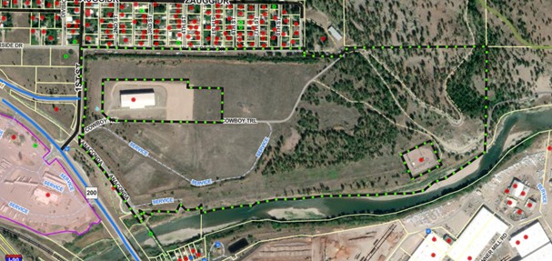
While this property is currently vacant, the County’s Growth Policy has designated most of it for heavy industrial use. With the growth policy amendment and rezoning, the developer proposes to reduce the area zoned heavy industrial to accommodate a new mixed-use development, including housing and commercial uses. Currently, 68 acres of this site are zoned Industrial Center Heavy (ICH), 17 acres are zoned Industrial Center Light (ICL), and 22 acres are zoned Agriculture, Working (AGW40). Under this proposal, the developer seeks to amend the zoning map as follows:
- Establish Commercial Center zoning on the west side of the property near the junction of Highway 200 and 1st Street. Preliminarily approved Blackfoot Crossing Subdivision, Lots 23, 24, 25, 26, and 27 are proposed to be zoned Commercial Center (CC); other zoning districts that may be considered for adoption for these lots are Neighborhood Commercial (NC) and Industrial Center Light (ICL). The developer has indicated that a travel plaza is intended for this area, and rezoning to Commercial Center (CC) would permit other retail, service, food and beverage, motel and office uses.
- Establish Neighborhood Center zoning that allows a broad range of housing, retail and office use. Proposed Blackfoot Crossing Riverfront Subdivision, Lots 5, 6, 7 and 8 are proposed to be zoned as Neighborhood Center (NC). This zone would establish a minimum density of eight units per acre and limit maximum building footprint and height. The developer's proposed housing development includes smaller, neighborhood-scale options: single-family homes on small lots, duplexes, triplexes, quadplexes, townhomes, and potentially larger units with six to eight homes.
- Rezone Common areas CA2 and CA4 as Resource and Open Lands (RO). These areas are intended to provide utility easements and increase access to nearby public lands.
The northeastern corner of the property (CA5) would remain unchanged, with a zoning designation of Agricultural Working Lands (AGW-40).
A full list of permitted uses by zone is available in Section 2.4, Chapter 2 of the County Zoning Regulations.
Minor Subdivision: This proposal also includes a five-lot minor subdivision called Blackfoot Crossing Riverfront. The subdivision is proposed in four phases over the next eight years. Each phase must function on its own, meaning roads, sidewalks, water, sewer, fire protection and stormwater systems are built as the project grows—not left for later.
Much of the land along the Blackfoot River is proposed to remain undeveloped as common area open space. Easements for a future public, non-motorized trail in the common area next to the river connect Milltown State Park, nearby neighborhoods and nearby public lands.
New roads would connect to Cowboy Trail and West Riverside Drive, with sidewalks on both sides and a bike- and pedestrian-friendly design. Traffic studies indicate that a future roundabout and intersection upgrades are planned when growth warrants them.
The site has been disturbed by past industrial use. Studies found no significant impacts on agriculture, limited wildlife habitat in developed areas, and no considerable groundwater or flood risks in the proposed building areas. Sensitive slopes and river-adjacent land are set aside as open space. Stormwater will be captured and infiltrated on-site, preventing runoff from flowing into the river.
The developer plans to create a new public water and sewer system to serve the new development and may also expand it to serve the surrounding area. The surrounding West Riverside community would not be required to connect to these systems; however, the systems will be designed to support future expansion into surrounding areas.
The proposed water supply wells must be permitted by the Montana Department of Environmental Quality (DEQ) as Public Water Supply sources. The wastewater treatment facility, a membrane bioreactor (MBR) system, has been submitted for DEQ permitting but has not yet been approved.
Additional information about the subdivision is provided in the links on the right side of this page.
Project Timeline:
Tuesday, Jan. 20, 6 p.m.: Missoula Consolidated Planning Board Meeting (Growth Policy Amendment and Rezoning)
- In-person location: 200 W. Broadway, Missoula County Courthouse, Sophie Moiese Room
- Virtual option: Residents can attend the meeting via Microsoft Teams. To join the meeting on your device, follow the links on the agenda that will be published on the Missoula County’s public meeting portal.
Thursday, March 5, 2 p.m.: County Commissioners’ Public Meeting (Growth Policy Amendment, Rezoning, and Minor Subdivision)
- In-person location: 200 W. Broadway, Missoula County Courthouse, Sophie Moiese Room
- Virtual option: Residents can attend the meeting via Microsoft Teams. To join the meeting on your device, follow the links on the agenda that will be published on the Missoula County’s public meeting portal.
Thursday, March 12, 2 p.m.: County Commissioners’ Public Meeting (Growth Policy Amendment, Rezoning, and Minor Subdivision)
- In-person location: 200 W. Broadway, Missoula County Courthouse, Sophie Moiese Room
- Virtual option: Residents can attend the meeting via Microsoft Teams. To join the meeting on your device, follow the links on the agenda that will be published on the Missoula County’s public meeting portal.
Thursday, July 9, 2 p.m.: County Commissioners’ Public Meeting (Growth Policy Amendment and Rezoning)
- In-person location: 200 W. Broadway, Missoula County Courthouse, Sophie Moiese Room
- Virtual option: Residents can attend the meeting via Microsoft Teams. To join the meeting on your device, follow the links on the agenda that will be published on the Missoula County’s public meeting portal.
Project Lead:
Kathleen Arthur, 406-258-3429
Ian Varley, 406-258-4653
Jennie Dixon, 406-258-4946
Important Links and Documents:
Growth Policy Amendment Request
Blackfoot Crossing Riverfront Public Notice
Blackfoot Crossing Riverfront Subdivision Application
Application for Governing Body Review
For more supporting documents, follow this link, and go to the Blackfoot Crossing Riverfront Project folder under Important Documents on the right-hand side.
Public Comment:
Submit public comment by using the comment tool below.
-
CZD 9 Accessory Structure Variance Request (Target Range)
Share CZD 9 Accessory Structure Variance Request (Target Range) on Facebook Share CZD 9 Accessory Structure Variance Request (Target Range) on X (formerly Twitter) Share CZD 9 Accessory Structure Variance Request (Target Range) on Linkedin Email CZD 9 Accessory Structure Variance Request (Target Range) linkUpdate: The public hearing meeting for this project has been moved to July 23 due to not enough members of the Planning and Zoning Commission, along with County Commissioners, being able to establish a quorum at the July 9 hearing. Residents are welcome to attend the July 23 hearing in-person and virtually.
Planning and Zoning Commission: Thursday, July 23, 2 p.m.
- In-person location: Sophie Moiese Room, Missoula County Courthouse Annex, 200 West Broadway, Missoula
- Virtual option: Residents can attend the meeting via Microsoft Teams. To join the call on your phone, call 406-272-4824, Conference ID 467 457 758#. To join the meeting on your device, follow the links on the agenda that will be published at http://missoula.co/bccmeetings
Project description
Sherra and Brandon Grosvenor are requesting two zoning variances for their property located at 905 Gladis Drive in the Target Range area of Missoula. These two zoning variances request the following:
- To allow construction of an accessory dwelling structure on the 0.32-acre parcel with a dry composting toilet . The parcel is currently too small to support an on-site septic system, which prevents residential development under current Health Department and DEQ standards. The Health Department has indicated a structure with a composting toilet is acceptable.
- Build 15 feet instead of 25 feet from the property line. This would allow a better layout for the accessory dwelling structure, align closer with the neighborhood dwelling pattern, provide room for RV storage and preserve usable outdoor space on the property.

What is a zoning variance?
A variance is a relaxation of specific provisions of the zoning regulations when literal enforcement of the regulations would result in unnecessary or undue hardship.
Project timeline
Planning and Zoning Commission: Thursday, July 9, 2 p.m. (cancelled)
- In-person location: Sophie Moiese Room, Missoula County Courthouse Annex, 200 West Broadway, Missoula
- Virtual option: Residents can attend the meeting via Microsoft Teams. To join the call on your phone, call 406-272-4824, Conference ID 467 457 758#. To join the meeting on your device, follow the links on the agenda that will be published at http://missoula.co/bccmeetings
Planning and Zoning Commission: Thursday, July 23, 2 p.m.
- In-person location: Sophie Moiese Room, Missoula County Courthouse Annex, 200 West Broadway, Missoula
- Virtual option: Residents can attend the meeting via Microsoft Teams. To join the call on your phone, call 406-272-4824, Conference ID 467 457 758#. To join the meeting on your device, follow the links on the agenda that will be published at http://missoula.co/bccmeetings
Public comment
Let us know what you think by logging in or creating an account and submitting your comment below.
Project lead
Katy Reeder, 406-258-3707
Important links and documents
-
Duff Family Transfer Exemption (Potomac)
Share Duff Family Transfer Exemption (Potomac) on Facebook Share Duff Family Transfer Exemption (Potomac) on X (formerly Twitter) Share Duff Family Transfer Exemption (Potomac) on Linkedin Email Duff Family Transfer Exemption (Potomac) linkProject Description
Kerry Duff is requesting to use the family transfer exemption from subdivision review to divide an existing 47.23-acre property at 26192 W Ashby Creek Road in Potomac into five tracts. The existing single-family residence and accessory structures would remain on the parent tract, while the remaining tracts are intended to be gifted to their children for future single-household residential use.

This request was previously approved by the county commissioners in 2022; however, the approval expired before the subdivision process could be completed due to the time required for Health Department review and groundwater monitoring. The current application has been submitted to re-establish the approval process.
Subdivision Regulations and Exemptions
Missoula County’s subdivision regulations promote public health, safety and general welfare by ensuring any subdivision of land in the County’s jurisdiction provides for adequate light, air, water supply, sewage disposal, parks and recreation areas, ingress and egress and other public requirements. Many requests to divide land must go through the subdivision process to ensure these requirements are met, but certain types of land division are exempt from subdivision review. Landowners can apply for one or multiple subdivision exemptions when their development plans meet the state and local requirements for the applicable exemptions.
Being granted these exemptions means the property owner does not need to go through the standard subdivision review process to divide their property. These requests require administrative review by planning staff and, in some cases, may require approval by the county commissioners to ensure the applicant is not evading these regulations.
- Family Transfer Exemption
Landowners can request a family transfer exemption when they intend to divide their property to gift or sell the newly created parcel(s) to an immediate family member.
View subdivision exemption criteria.
What is a family transfer?
Montana law specifically allows landowners to divide land and gift or sell one parcel per immediate family member (like a child, parent or spouse), without full subdivision review.
Requests for family transfers must always come before the commissioners. Missoula County considers dozens of family land transfers every year. It’s not rare — other counties across Montana regularly process these applications too. It’s not a loophole — it’s in the law for a reason: to help families live near each other or pass down land. It’s does not skirt regulations — the process requires surveys, documentation, fees and approval by county commissioners.
The landowner and recipient must be real people, not LLCs or corporations. It can only be used once per family member per county.
Project Timeline
County commissioners hearing: Thursday, July 23, 2 p.m.
- In-person location: Sophie Moiese Room, Missoula County Courthouse Annex, 200 West Broadway, Missoula
- Virtual option: Residents can attend the meeting via Microsoft Teams. To join the call on your phone, call 406-272-4824, Conference ID 467 457 758#. To join the meeting on your device, follow the links on the agenda that will be published at http://missoula.co/bccmeetings
Project Lead
Katy Reeder, 406-258-3707
Public Comment
Submit public comment by using the comment tool below.
Important Links and Documents
- Family Transfer Exemption
-
Floodplain Development Permit No. 26-16 (Huson)
Share Floodplain Development Permit No. 26-16 (Huson) on Facebook Share Floodplain Development Permit No. 26-16 (Huson) on X (formerly Twitter) Share Floodplain Development Permit No. 26-16 (Huson) on Linkedin Email Floodplain Development Permit No. 26-16 (Huson) linkProject description:
The Missoula County Planning, Development and Sustainability Department (PDS) has received Floodplain Development Permit Application #26-16 from Confluence Consulting Inc., on behalf of the Montana Department of Transportation, for stream restoration work.
The primary purpose of the Floodplain Development Permit is to promote public health, safety, and general welfare, to minimize flood losses in areas subject to flood hazards, and to promote wise use of the floodplain.
Project location:
The site is located at the lower reach of Six Mile Creek near 16905 Six Mile Road in the FEMA-designated Six Mile Creek floodplain: Parcels 1 & 2, COS 4795, S26, T15N, R22W, Missoula County. See location here.

The full application is available for review online or in the PDS office at 131 E Main St., in Missoula.
Please feel free to call 406-258-4657 or email floodplain@missoulacounty.us with any questions or to make an appointment to review the permit application.
Public comment:
Submit public comment through Monday, June 8, by using the comment tool below, emailing floodplain@missoulacounty.us or mailing to Planning, Development and Sustainability, Attn: Matt Heimel, Floodplain Administrator, 200 W. Broadway St., Missoula MT 59802.
Important links and documents:
-
Floodplain Development Permit No. 26-13
Share Floodplain Development Permit No. 26-13 on Facebook Share Floodplain Development Permit No. 26-13 on X (formerly Twitter) Share Floodplain Development Permit No. 26-13 on Linkedin Email Floodplain Development Permit No. 26-13 linkProject description:
The Missoula County Planning, Development and Sustainability Department (PDS) has received Floodplain Development Permit Application #26-13 from Gretchen Watkins for stream restoration work.
The primary purpose of the Floodplain Development Permit is to promote public health, safety and general welfare, to minimize flood losses in areas subject to flood hazards, and to promote wise use of the floodplain.
Project location:
The site is located at the lower reach of Grant Creek near 1655 Frey Lane in the FEMA-designate Clark Fork River floodplain: Tracts D & E, COS 5108, S14, T13N, R20W, in Missoula County. See location here.

The full application is available for review online or in the PDS office at 131 E Main St., in Missoula.
Please feel free to call 406-258-4657 or email floodplain@missoulacounty.us with any questions or to make an appointment to review the permit application.
Public comment:
Submit public comment through Monday, June 8, by using the comment tool below, emailing floodplain@missoulacounty.us or mailing to Planning, Development and Sustainability, Attn: Matt Heimel, Floodplain Administrator, 200 W. Broadway St., Missoula MT 59802.
Important links and documents:
-
Floodplain Development No. 26-12
Share Floodplain Development No. 26-12 on Facebook Share Floodplain Development No. 26-12 on X (formerly Twitter) Share Floodplain Development No. 26-12 on Linkedin Email Floodplain Development No. 26-12 linkProject Description
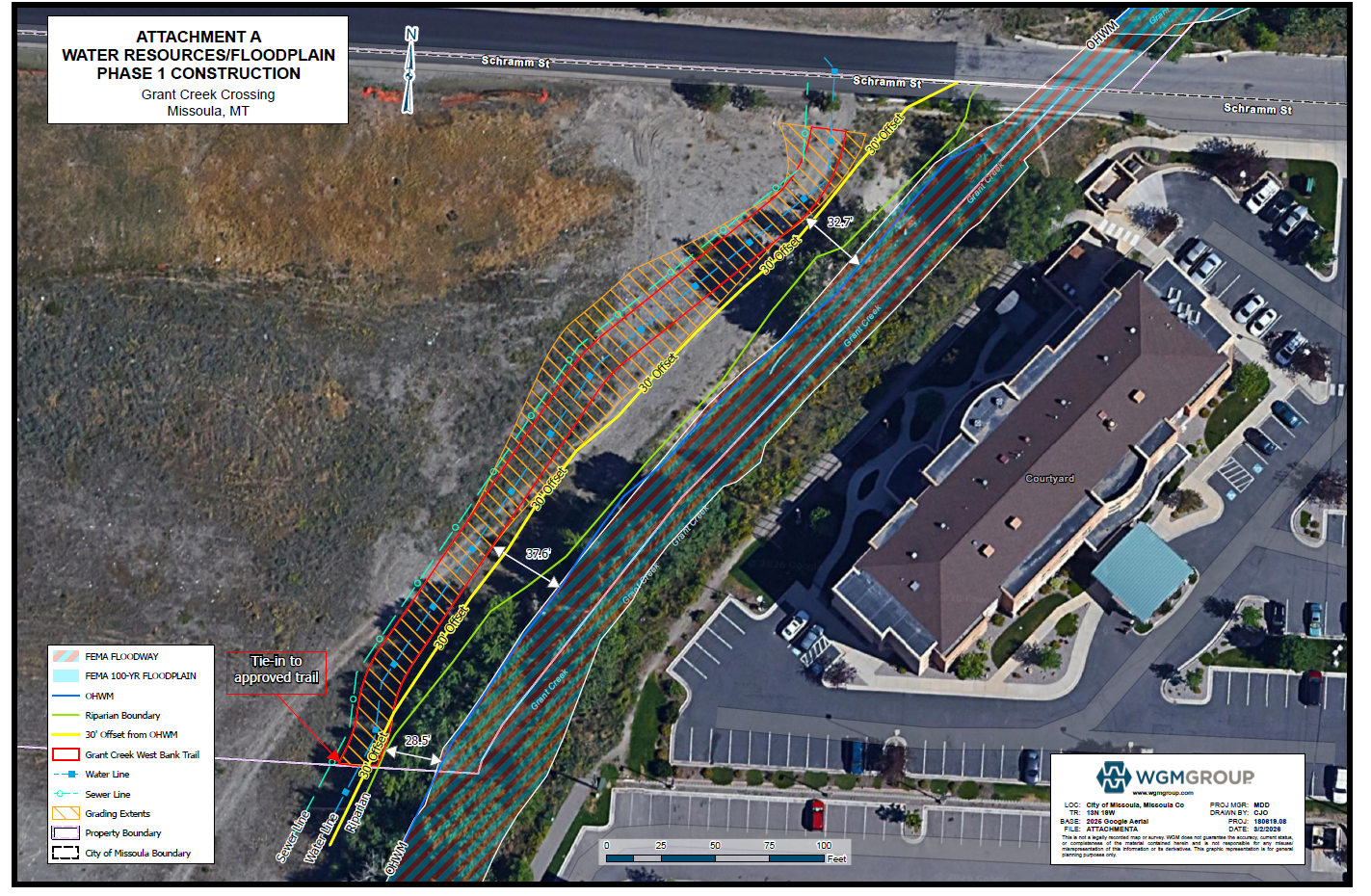
The Missoula County Planning, Development and Sustainability Department (PDS) has received a Floodplain Development Permit #26-12 from Grant Creek Crossing – Missoula LLC for reconstruction of Schramm Street in the Grant Creek regulated flood hazard area.
The site is located at the Schramm Street crossing over Grant Creek, about 725 feet of Reserve Street: Tract 3A-1B COS 7031, S05, T13N, R19W in Missoula County.
What is a floodplain development permit?
The primary purpose of a floodplain development permit is to promote public health, safety and general welfare, to minimize flood losses in areas subject to flood hazards, and to promote wise use of the floodplain.
Public Comment
Submit public comment by 5 p.m., Monday, April 6, through the following three ways.
- Use the comment tool below. You must be registered on Missoula County Voice
- Email floodplain@missoulacounty.us
- Mail to Planning, Development and Sustainability
- Attn: Matt Heimel, Floodplain Administrator, 200 W. Broadway St., Missoula, MT 59802
Questions or want to make an appointment?
Please feel free to call 406-258-4647 or email floodplain@missoulacounty.us with any questions or to make an appointment to review the permit application.
Important Documents and Links
Floodplain and Shoreline Administration Webpage
Physical applications are available in the PDS office at 127 E. Main St., Suite 2, in downtown Missoula
This permit is subject to approval by the floodplain administrator and does not go before the county commissioners.
-
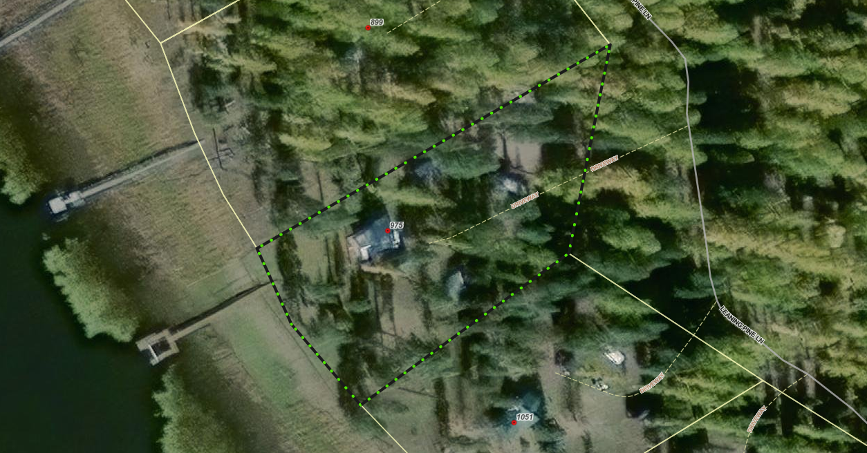
Floodplain Development No. 26-08 (Seeley Lake)
Share Floodplain Development No. 26-08 (Seeley Lake) on Facebook Share Floodplain Development No. 26-08 (Seeley Lake) on X (formerly Twitter) Share Floodplain Development No. 26-08 (Seeley Lake) on Linkedin Email Floodplain Development No. 26-08 (Seeley Lake) linkProject Description
The Missoula County Planning, Development and Sustainability Department (PDS) has received a Floodplain Development Permit Application #26-08 from Amee Tafoya for reconstruction of a cabin in the Clearwater River regulated flood hazard area.
The site is located at 975 Leaning Pine Drive on state-leased land: Parcel: 13, COS 4875, S)4, T16N, R15W in Missoula County.
What is a floodplain permit?
The primary purpose of a Floodplain Development Permit is to promote public health, safety, and general welfare, to minimize flood losses in areas subject to flood hazards, and to promote wise use of the floodplain.
Public Comment
Submit public comment by 5 p.m., Monday, April 6, through the following three ways.
- Use the comment tool below. You must be registered on Missoula County Voice
- Email floodplain@missoulacounty.us
- Mail to Planning, Development and Sustainability
- Attn: Matt Heimel, Floodplain Administrator, 200 W. Broadway St., Missoula, MT 59802
Questions or want to make an appointment?
Please feel free to call 406-258-4647 or email floodplain@missoulacounty.us with any questions or to make an appointment to review the permit application.
Important Documents and Links
Floodplain Permit Application and Value Estimates – 8.28.25
Floodplain Permit Application and Values Estimates – 9.18.25
Floodplain and Shoreline Administration Webpage
Physical applications are available in the PDS office at 127 E. Main St., Suite 2 in downtown Missoula
This permit is subject to approval by the floodplain administrator and does not go before the county commissioners.
-
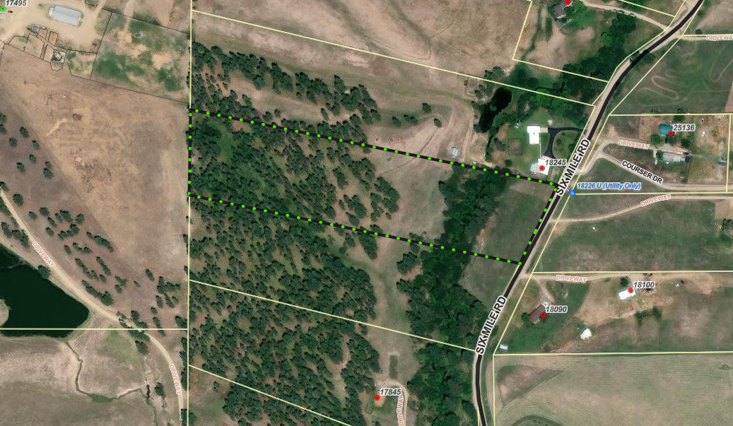
Floodplain Development No. 26-05 (Frenchtown)
Share Floodplain Development No. 26-05 (Frenchtown) on Facebook Share Floodplain Development No. 26-05 (Frenchtown) on X (formerly Twitter) Share Floodplain Development No. 26-05 (Frenchtown) on Linkedin Email Floodplain Development No. 26-05 (Frenchtown) linkProject Description
The Missoula County Planning, Development & Sustainability Department (PDS) has received a Floodplain Development Permit Application #26-05 from George Neumunz for construction of a stream crossing in the Sixmile Creek regulated flood hazard area.
The site is located on the west side of the Sixmile Road: Lot 21 of Six Mile Timber Tracts #2, S23, T15N, R22W, Missoula County.
What is a floodplain development permit?
The primary purpose of the floodplain development permit is to promote the public health, safety, and general welfare, to minimize flood losses in areas subject to flood hazards, and to promote wise use of the floodplain.
Public Comment:
Submit public comment by 5 p.m., Monday, April 6 through the following three ways.
- Use the comment tool below. You must be registered on Missoula County Voice
- Email floodplain@missoulacounty.us
- Mail to Planning, Development, & Sustainability
- Attn: Matt Heimel, Floodplain Administrator, 200 W. Broadway St., Missoula, MT 59802
Questions or want to make an appointment?
Please feel free to call 406-258-4647 or email floodplain@missoulacounty.us with any questions or to make an appointment to review the permit application.
Important Documents and Links:
Supplemental and Revised Packet
Floodplain and Shoreline Administration Webpage
Physical applications are available in the PDS office at 127 E. Main St., Suite 2 in downtown Missoula
This permit is subject to approval by the floodplain administrator and does not go before the county commissioners.
