Development Projects
Let us know your thoughts on private development projects happening in Missoula County.
Missoula County routinely considers development projects such as subdivisions, family transfers, boundary line relocations and rezoning requests. The projects featured on this page first come to the Planning, Development and Sustainability Department to ensure they meet various requirements related to zoning, land use, floodplain and other regulations. The Board of County Commissioners or the relevant decision-making body then considers approval of projects at their public meetings.
Comments on these projects help planning staff more accurately present to the commissioners how the community feels about the proposals, so the commissioners can make well-informed decisions on each project.
-
Floodplain Development Permit No. 26-21
Share Floodplain Development Permit No. 26-21 on Facebook Share Floodplain Development Permit No. 26-21 on X (formerly Twitter) Share Floodplain Development Permit No. 26-21 on Linkedin Email Floodplain Development Permit No. 26-21 linkProject Description
The Missoula County Planning, Development and Sustainability Department (PDS) has received Floodplain Development Permit Application #26-21 from Andrew D. Sellars to build a new accessory structure in the floodplain.

The primary purpose of a Floodplain Development Permit is to promote public health, safety and general welfare, to minimize flood losses in areas subject to flood hazards, and to promote wise use of the floodplain.
Project Location
The property is located at 4375 US Highway 93 in the Bitterroot River floodplain. See location here.
The full application is available for review online or in the PDS office at 131 East Main St. in Missoula.
Please feel free to call 406-258-4657 or email floodplain@missoulacounty.us with any questions or to make an appointment to review the permit application.
Public Comment
Submit comments by 5 p.m. Friday, August 12, by using the comment tool below, emailing floodplain@missoulacounty.us or mailing to Planning, Development and Sustainability, Attn: Matt Heimel, Floodplain Administrator, 200 W. Broadway St., Missoula MT 59802.
Related Documents and Links
-
Floodplain Development Permit No. 26-20
Share Floodplain Development Permit No. 26-20 on Facebook Share Floodplain Development Permit No. 26-20 on X (formerly Twitter) Share Floodplain Development Permit No. 26-20 on Linkedin Email Floodplain Development Permit No. 26-20 linkProject Description
The Missoula County Planning, Development and Sustainability Department (PDS) has received Floodplain Development Permit Application #26-20 from Tollefson Properties LLC to build a utility enclosure for a pump that is part of a project to divert water from the Bitterroot River to Miller Creek.

The primary purpose of a Floodplain Development Permit is to promote public health, safety and general welfare, to minimize flood losses in areas subject to flood hazards, and to promote wise use of the floodplain.
Project Location
The property is located at 6225 Haugan Drive in the Bitterroot River floodplain, S14, T12N, R20W, Missoula County. See location here.
The full application is available for review online or in the PDS office at 131 East Main St. in Missoula.
Please feel free to call 406-258-4657 or email floodplain@missoulacounty.us with any questions or to make an appointment to review the permit application.
Public Comment
Submit comments by 5 p.m. Friday, August 12, by using the comment tool below, emailing floodplain@missoulacounty.us or mailing to Planning, Development and Sustainability, Attn: Matt Heimel, Floodplain Administrator, 200 W. Broadway St., Missoula MT 59802.
Related Documents and Links
-
Floodplain Development Permit No. 26-22
Share Floodplain Development Permit No. 26-22 on Facebook Share Floodplain Development Permit No. 26-22 on X (formerly Twitter) Share Floodplain Development Permit No. 26-22 on Linkedin Email Floodplain Development Permit No. 26-22 linkProject Description
The Missoula County Planning, Development and Sustainability Department (PDS) has received Floodplain Development Permit Application #26-22 from Nicholas Caras to make improvements to an existing commercial building.
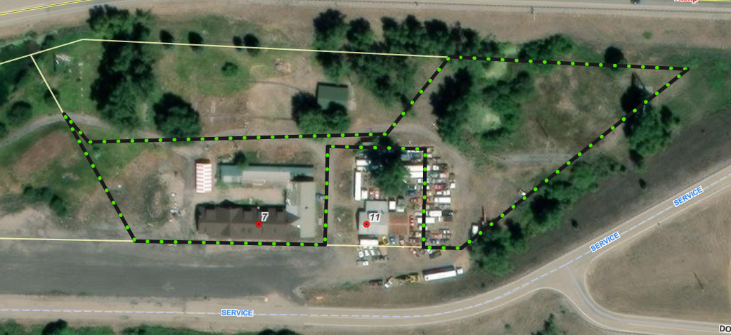
The primary purpose of a Floodplain Development Permit is to promote public health, safety and general welfare, to minimize flood losses in areas subject to flood hazards, and to promote wise use of the floodplain.
Project Location
The site is located at 7 Rock Creek Road in the Clark Fork River floodplain: Parcel C of COS 1041, S12, T11N, R17W, Missoula County. See location here.
The full application is available for review online or in the PDS office at 131 East Main St. in Missoula.
Please feel free to call 406-258-4657 or email floodplain@missoulacounty.us with any questions or to make an appointment to review the permit application.
Public Comment
Submit comments by 5 p.m. Friday, July 24, by using the comment tool below, emailing floodplain@missoulacounty.us or mailing to Planning, Development and Sustainability, Attn: Matt Heimel, Floodplain Administrator, 200 W. Broadway St., Missoula MT 59802.
Related Documents and Links
-
Floodplain Development Permit No. 26-19
Share Floodplain Development Permit No. 26-19 on Facebook Share Floodplain Development Permit No. 26-19 on X (formerly Twitter) Share Floodplain Development Permit No. 26-19 on Linkedin Email Floodplain Development Permit No. 26-19 linkProject Description
The Missoula County Planning, Development and Sustainability Department (PDS) has received Floodplain Development Permit Application #26-19 from the Montana Department of Fish, Wildlife and Parks to stabilize a section of streambank adjacent to Kona Bridge Fishing Access site.
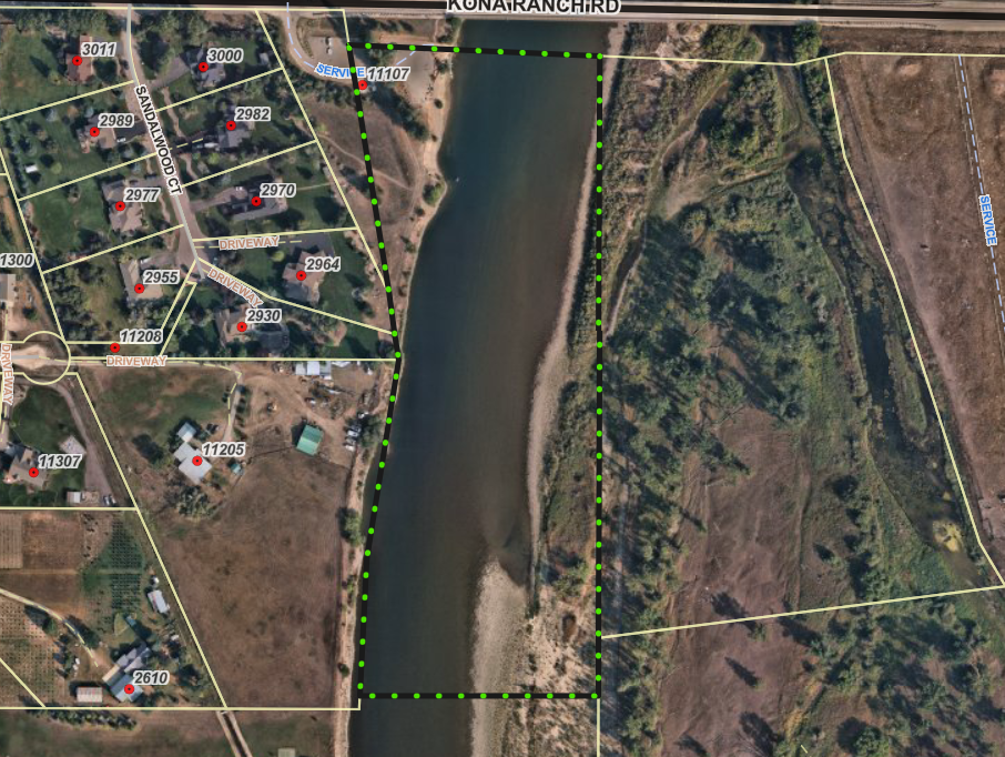
The primary purpose of a Floodplain Development Permit is to promote public health, safety and general welfare, to minimize flood losses in areas subject to flood hazards, and to promote wise use of the floodplain.
Project Location
The site is located at 11107 Kona Ranch Road in the Clark Fork River floodplain: S8, T13N, R20W, Missoula County. See location here.
The full application is available for review online or in the PDS office at 131 East Main St. in Missoula.
Please feel free to call 406-258-4657 or email floodplain@missoulacounty.us with any questions or to make an appointment to review the permit application.
Public Comment
Submit comments by 5 p.m. Friday, July 24, by using the comment tool below, emailing floodplain@missoulacounty.us or mailing to Planning, Development, & Sustainability, Attn: Matt Heimel, Floodplain Administrator, 200 W. Broadway St., Missoula MT 59802.
Related Documents and Links
-
Floodplain Development Permit No. 26-18
Share Floodplain Development Permit No. 26-18 on Facebook Share Floodplain Development Permit No. 26-18 on X (formerly Twitter) Share Floodplain Development Permit No. 26-18 on Linkedin Email Floodplain Development Permit No. 26-18 linkProject Description
The Missoula County Planning, Development, & Sustainability Department (PDS) has received Floodplain Development Permit Application #26-18 from the Montana Department of Fish, Wildlife and Parks to stabilize a section of streambank that is adjacent to the Kelly Island Fishing Access site.
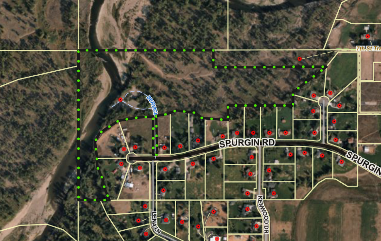
The primary purpose of a Floodplain Development Permit is to promote the public health, safety, and general welfare, to minimize flood losses in areas subject to flood hazards, and to promote wise use of the floodplain.
Project Location
The site is located at 4854 Spurgin Road in the Clark Fork River floodplain: S26, T13N, R20W, Missoula County. See location here.
The full application is available for review online or in the PDS office at 131 East Main St. in Missoula.
Please feel free to call 406-258-4657 or email floodplain@missoulacounty.us with any questions or to make an appointment to review the permit application.
Public Comment
Submit comments by 5 p.m. Friday, July 24, by using the comment tool below, emailing floodplain@missoulacounty.us or mailing to Planning, Development, & Sustainability, Attn: Matt Heimel, Floodplain Administrator, 200 W. Broadway St., Missoula MT 59802.
Related Documents and Links
-
Floodplain Development No. 26-12
Share Floodplain Development No. 26-12 on Facebook Share Floodplain Development No. 26-12 on X (formerly Twitter) Share Floodplain Development No. 26-12 on Linkedin Email Floodplain Development No. 26-12 linkProject Description
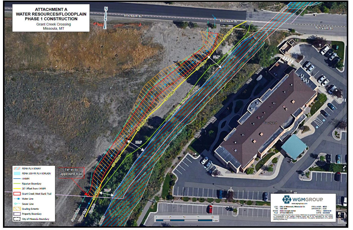
The Missoula County Planning, Development and Sustainability Department (PDS) has received a Floodplain Development Permit #26-12 from Grant Creek Crossing – Missoula LLC for reconstruction of Schramm Street in the Grant Creek regulated flood hazard area.
The site is located at the Schramm Street crossing over Grant Creek, about 725 feet of Reserve Street: Tract 3A-1B COS 7031, S05, T13N, R19W in Missoula County.
What is a floodplain development permit?
The primary purpose of a floodplain development permit is to promote public health, safety and general welfare, to minimize flood losses in areas subject to flood hazards, and to promote wise use of the floodplain.
Public Comment
Submit public comment by 5 p.m., Monday, April 6, through the following three ways.
- Use the comment tool below. You must be registered on Missoula County Voice
- Email floodplain@missoulacounty.us
- Mail to Planning, Development and Sustainability
- Attn: Matt Heimel, Floodplain Administrator, 200 W. Broadway St., Missoula, MT 59802
Questions or want to make an appointment?
Please feel free to call 406-258-4647 or email floodplain@missoulacounty.us with any questions or to make an appointment to review the permit application.
Important Documents and Links
Floodplain and Shoreline Administration Webpage
Physical applications are available in the PDS office at 127 E. Main St., Suite 2, in downtown Missoula
This permit is subject to approval by the floodplain administrator and does not go before the county commissioners.
-
Floodplain Development No. 26-08 (Seeley Lake)
Share Floodplain Development No. 26-08 (Seeley Lake) on Facebook Share Floodplain Development No. 26-08 (Seeley Lake) on X (formerly Twitter) Share Floodplain Development No. 26-08 (Seeley Lake) on Linkedin Email Floodplain Development No. 26-08 (Seeley Lake) linkProject Description
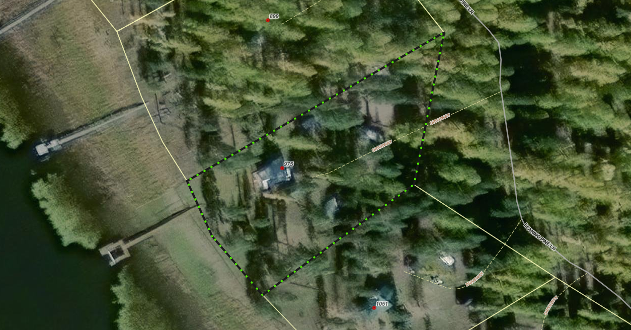
The Missoula County Planning, Development and Sustainability Department (PDS) has received a Floodplain Development Permit Application #26-08 from Amee Tafoya for reconstruction of a cabin in the Clearwater River regulated flood hazard area.
The site is located at 975 Leaning Pine Drive on state-leased land: Parcel: 13, COS 4875, S)4, T16N, R15W in Missoula County.
What is a floodplain permit?
The primary purpose of a Floodplain Development Permit is to promote public health, safety, and general welfare, to minimize flood losses in areas subject to flood hazards, and to promote wise use of the floodplain.
Public Comment
Submit public comment by 5 p.m., Monday, April 6, through the following three ways.
- Use the comment tool below. You must be registered on Missoula County Voice
- Email floodplain@missoulacounty.us
- Mail to Planning, Development and Sustainability
- Attn: Matt Heimel, Floodplain Administrator, 200 W. Broadway St., Missoula, MT 59802
Questions or want to make an appointment?
Please feel free to call 406-258-4647 or email floodplain@missoulacounty.us with any questions or to make an appointment to review the permit application.
Important Documents and Links
Floodplain Permit Application and Value Estimates – 8.28.25
Floodplain Permit Application and Values Estimates – 9.18.25
Floodplain and Shoreline Administration Webpage
Physical applications are available in the PDS office at 127 E. Main St., Suite 2 in downtown Missoula
This permit is subject to approval by the floodplain administrator and does not go before the county commissioners.
-
Floodplain Development No. 26-05 (Frenchtown)
Share Floodplain Development No. 26-05 (Frenchtown) on Facebook Share Floodplain Development No. 26-05 (Frenchtown) on X (formerly Twitter) Share Floodplain Development No. 26-05 (Frenchtown) on Linkedin Email Floodplain Development No. 26-05 (Frenchtown) linkProject Description
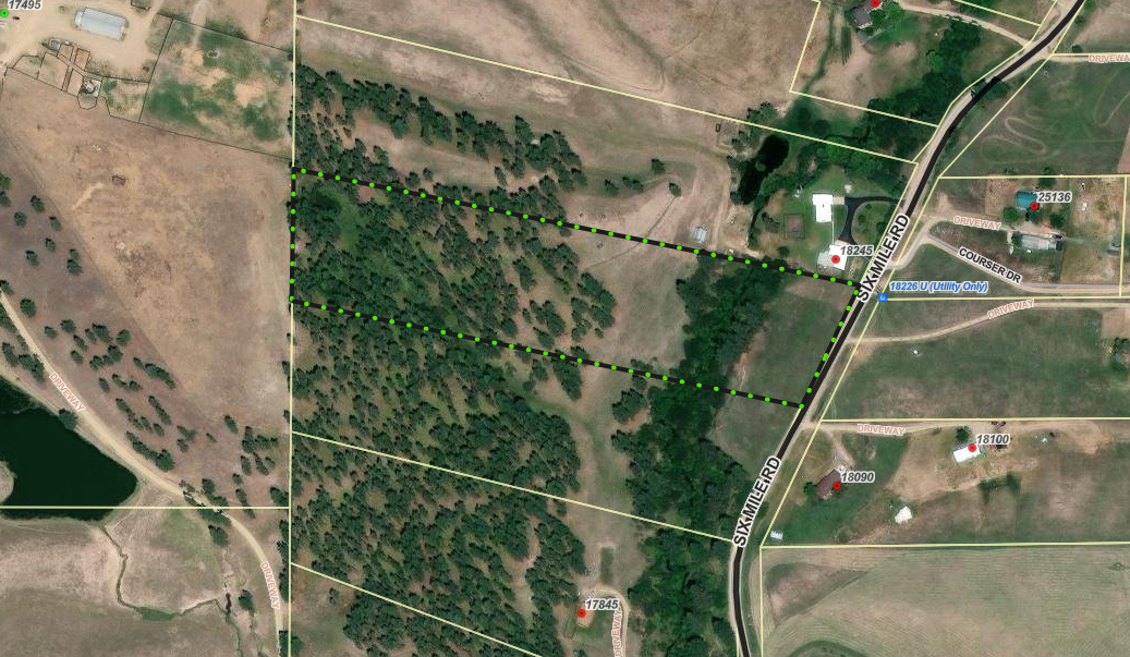
The Missoula County Planning, Development & Sustainability Department (PDS) has received a Floodplain Development Permit Application #26-05 from George Neumunz for construction of a stream crossing in the Sixmile Creek regulated flood hazard area.
The site is located on the west side of the Sixmile Road: Lot 21 of Six Mile Timber Tracts #2, S23, T15N, R22W, Missoula County.
What is a floodplain development permit?
The primary purpose of the floodplain development permit is to promote the public health, safety, and general welfare, to minimize flood losses in areas subject to flood hazards, and to promote wise use of the floodplain.
Public Comment:
Submit public comment by 5 p.m., Monday, April 6 through the following three ways.
- Use the comment tool below. You must be registered on Missoula County Voice
- Email floodplain@missoulacounty.us
- Mail to Planning, Development, & Sustainability
- Attn: Matt Heimel, Floodplain Administrator, 200 W. Broadway St., Missoula, MT 59802
Questions or want to make an appointment?
Please feel free to call 406-258-4647 or email floodplain@missoulacounty.us with any questions or to make an appointment to review the permit application.
Important Documents and Links:
Supplemental and Revised Packet
Floodplain and Shoreline Administration Webpage
Physical applications are available in the PDS office at 127 E. Main St., Suite 2 in downtown Missoula
This permit is subject to approval by the floodplain administrator and does not go before the county commissioners.
-
Floodplain Development No. 26-03
Share Floodplain Development No. 26-03 on Facebook Share Floodplain Development No. 26-03 on X (formerly Twitter) Share Floodplain Development No. 26-03 on Linkedin Email Floodplain Development No. 26-03 linkProject Description
The Missoula County Planning, Development, & Sustainability Department (PDS) has received Floodplain Development Permit Application #26-03 from Gregory Axtman for electrical utility work.
The primary purpose of a Floodplain Development Permit is to promote the public health, safety, and general welfare, to minimize flood losses in areas subject to flood hazards, and to promote wise use of the floodplain.
Project Location
The site is located at 1744 Snowmass Drive in the Clearwater River regulated flood hazard area: Parcel 15 of COS 5140, Section 04, Township 16 North, Range 15 West, Missoula County. See location here.
The full application is available for review online or in the PDS office at 127 E. Main St., Suite 2, in Missoula.
Please feel free to call 406-258-4657 or email floodplain@missoulacounty.us with any questions or to make an appointment to review the permit application.
Public Comment
Submit comments by 5 p.m., Friday, Oct. 17, by using the comments tools below, by emailing floodplain@missoulacounty.us or mailing to Planning, Development, & Sustainability, Attn: Matt Heimel, Floodplain Administrator, 200 W. Broadway St., Missoula MT 59802.
Related Documents and Links
This permit is subject to approval by the floodplain administrator and does not go before the Board of County Commissioners.
-
Ramsbacher Family Transfer Exemption
Share Ramsbacher Family Transfer Exemption on Facebook Share Ramsbacher Family Transfer Exemption on X (formerly Twitter) Share Ramsbacher Family Transfer Exemption on Linkedin Email Ramsbacher Family Transfer Exemption linkProject Description
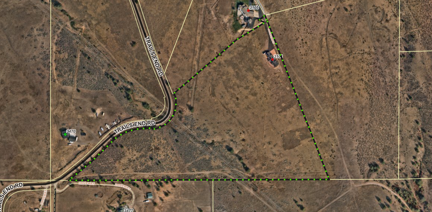
Ron and Valerie Ramsbacher are requesting to use the family transfer exemption from subdivision review to divide an existing 24.54-acre property at 3101 Evan’s Ridge Road into two tracts.
The existing single-family residence and accessory structures would remain on the parent tract, while the remaining 6-acre tract would be gifted to their son for a future single-family residence.
What is a family transfer?
Montana law specifically allows landowners to divide land and gift or sell one parcel per immediate family member (like a child, parent or spouse), without full subdivision review.
Requests for family transfers must always come before the commissioners. Missoula County considers dozens of family land transfers every year. It’s not rare — other counties across Montana regularly process these applications too. It’s not a loophole — it’s in the law for a reason: to help families live near each other or pass down land. It’s does not skirt regulations — the process requires surveys, documentation, fees and approval by county commissioners.
The landowner and recipient must be real people, not LLCs or corporations. It can only be used once per family member per county.
Project Timeline
County commissioners hearing: public hearing date has not been set yet
- In-person location: Sophie Moiese Room, Missoula County Courthouse Annex, 200 West Broadway, Missoula
- Virtual option: Residents can attend the meeting via Microsoft Teams. To join the call on your phone, call 406-272-4824, Conference ID 467 457 758#. To join the meeting on your device, follow the links on the agenda that will be published at http://missoula.co/bccmeetings
Project Lead
Jennie Dixon, 406-258-4946
Public Comment
Submit public comment by using the comment tool below.
Important Links and Documents
Ramsbacher Family Transfer application

-

Phone 406-258-4794 -
Planner III/Floodplain Administrator
Missoula County Planning, Development and Sustainability

Phone 406-258-3799 -

Phone 406-258-4946 -

Phone 406-258-3425 -

Phone 406-258-3706 -

Phone 406-258-4841 -

Phone 406-258-4652 -

Phone 406-258-3707
-
 Shoreline Permit & Variance Application #25-06
-
 0 Cover letter.docx (22.5 KB) (docx)
-
1 County Shoreline Construction Permit.pdf (410 KB) (pdf)
-
2 DCI Engineering Shoreline Restoration letter.docx (203 KB) (docx)
-
3 County Shoreline Restoration Application Addendum.docx (46 KB) (docx)
-
4 Linford Colgan Vicinity Map.docx (257 KB) (docx)
-
5 Seeley Lake Shore Sites COS 53653.pdf (725 KB) (pdf)
-
6 Seeley Lake Shore Sites COS 53653 Enlarged.docx (316 KB) (docx)
-
7 Lots 78 80 82 Retracement COS 6242 2010.pdf (108 KB) (pdf)
-
8 Existing Conditions Photos.docx (1.22 MB) (docx)
-
9 Project Area Map.docx (1.17 MB) (docx)
-
10 MTNHWRD Map.docx (291 KB) (docx)
-
11 Site Plan Diagram.pdf (168 KB) (pdf)
-
12 Site Plan Cross Section Diagram.pdf (475 KB) (pdf)
-
13 Restoration Erosion Sed Runoff Plan Diagram.pdf (159 KB) (pdf)
-
14 Lakeside Interface Berm Diagram.pdf (166 KB) (pdf)
-
15 County Shoreline Permit Variance Request.docx (33.3 KB) (docx)
-
16 County Shoreline Restoration Application Project Impact Assessment.docx (52.5 KB) (docx)
-
2025_10_22 FACTS ACK_MTB013622_20062.PDF (179 KB) (PDF)
-
2025_10_22 FACTS APP_MTB013622_20062.PDF (309 KB) (PDF)
-
2025_10_29 FACTS permit AUTH_MTB013622_20062.PDF (192 KB) (PDF)
-
2026_01_05 cover letter for permit.pdf (429 KB) (pdf)
-
LUL Application Form .doc (128 KB) (doc)
-
navigable river license dnrc.pdf (1.94 MB) (pdf)
-
1 2021_NWP-13-FS_links.pdf (348 KB) (pdf)
-
1 20200219_SLOPES renewal_AppE_Conservation Measures.pdf (141 KB) (pdf)
-
1 Certification of Compliance.pdf (54.9 KB) (pdf)
-
1 Permit Verification.pdf (270 KB) (pdf)
-
1 SLOPES PROJECT COMPLETION REPORT FORM.docx (25.6 KB) (docx)
-
2026_05_20 404 permit update.docx (21.6 KB) (docx)
-
SL2606 Staff Report .pdf (275 KB) (pdf)
-
-
Blackfoot Crossing Project
-
01_Growth Policy Amendment Request2.0.pdf (739 KB) (pdf)
-
02_Zoning Amendment Application.pdf (317 KB) (pdf)
-
03_Existing Land Use.pdf (518 KB) (pdf)
-
04_Proposed Land Use.pdf (532 KB) (pdf)
-
05_Working Lands Land Use.pdf (383 KB) (pdf)
-
06_Open Resource and Recreation Land Use.pdf (383 KB) (pdf)
-
07_Neighborhood Center Land Use.pdf (368 KB) (pdf)
-
08_Commercial Center Land Use.pdf (350 KB) (pdf)
-
09_Industrial Center Land Use.pdf (353 KB) (pdf)
-
10_Heavy Industrial Center Land Use.pdf (361 KB) (pdf)
-
11_Existing Zoning.pdf (550 KB) (pdf)
-
12_Proposed Zoning.pdf (551 KB) (pdf)
-
13_Zoning Uses.pdf (190 KB) (pdf)
-
14_Aerial Topo.pdf (1.35 MB) (pdf)
-
15_Existing Conditions.pdf (907 KB) (pdf)
-
16_01 Legal Constraints.pdf (684 KB) (pdf)
-
17_WUI.pdf (186 KB) (pdf)
-
18_Slopes.pdf (5.65 MB) (pdf)
-
19_High Pressure Gas Lines.pdf (456 KB) (pdf)
-
20_utilities.pdf (581 KB) (pdf)
-
21_Earthquake Faults.pdf (2.12 MB) (pdf)
-
22_avalanche slope.pdf (1.15 MB) (pdf)
-
23_Hazardous Waste.pdf (435 KB) (pdf)
-
24_Healthcare Facilities.pdf (695 KB) (pdf)
-
25_Dam Failure.pdf (343 KB) (pdf)
-
26_Vegetation.pdf (1.51 MB) (pdf)
-
27_Flooplain.pdf (1.3 MB) (pdf)
-
28_Hydrology.pdf (740 KB) (pdf)
-
29_Wildlife Distribution.pdf (1.77 MB) (pdf)
-
30_Transportation.pdf (1.92 MB) (pdf)
-
31_Cultural Resource Inventory.pdf (6.87 MB) (pdf)
-
32_Soils Report.pdf (1.26 MB) (pdf)
-
33_Blackfoot Crossing 1 Subdivision.pdf (4.17 MB) (pdf)
-
34_Blackfoot Crossing 1 Sub Phasing Plan.pdf (345 KB) (pdf)
-
35_Blackfoot Riverfront Pplat.pdf (2.39 MB) (pdf)
-
36_ Riverfront Phasing.pdf (359 KB) (pdf)
-
37_Preliminary Stormwater Report.pdf (8 MB) (pdf)
-
38_Test Pits.pdf (159 KB) (pdf)
-
39_Well Logs.pdf (1.39 MB) (pdf)
-
40_02_Neighborhood Meeting Letter_Mtg 1.pdf (111 KB) (pdf)
-
40_04_PowerPoint Presentation_Mtg 1.pdf (9.6 MB) (pdf)
-
40_06_Neighborhood Meeting Summary_Mtg 1.pdf (130 KB) (pdf)
-
40_07_Neighborhood Comment_Mtg 1.pdf (715 KB) (pdf)
-
41_02_Neighborhood Meeting Letter_Mtg 2.pdf (118 KB) (pdf)
-
41_04_PowerPoint Presentation_Mtg 2.pdf (4.79 MB) (pdf)
-
41_05_Neighborhood Meeting Summary_Mtg 2.pdf (1000 KB) (pdf)
-
42_01_September 9 2025 Community Council Agenda.pdf (665 KB) (pdf)
-
42_02 Community Council Meeting Summary.pdf (39.4 KB) (pdf)
-
42_03_ Community Council Meeting Transcript.pdf (217 KB) (pdf)
-
42_04_Community Council Meeting Presentation.pdf (4.66 MB) (pdf)
-
42_05_Community Council Draft Meeting Minutes.pdf (706 KB) (pdf)
-
43_2009 Community Visioning Map.pdf (475 KB) (pdf)
-
44_2009 BMCC Meeting record (NEW 10.25).pdf (468 KB) (pdf)
-
45_Traffic Impact Study.pdf (22.4 MB) (pdf)
-
46_Tech Memo West Riverside Access Impacts.pdf (1.05 MB) (pdf)
-
BFXR Sub Rpt_FINAL.pdf (1.72 MB) (pdf)
-
Approved rezone.pdf (549 KB) (pdf)
-
Approved growth policy designation.pdf (532 KB) (pdf)
-
-
Floodplain Development Permit #26-24
-
Brown Family Transfer
-
0 Cover Letter.pdf (50.8 KB) (pdf)
-
1 2023 Family Transfer Exemption Application and Affidavit.2023.Fillable.Form.pdf (1.17 MB) (pdf)
-
1.2 Signed Family Transfer Division of Land Affidavit.pdf (1.32 MB) (pdf)
-
1.5 Signed Landowner Letter.pdf (497 KB) (pdf)
-
1.7 WarrantyDeed.pdf (35.2 KB) (pdf)
-
2 Dinsmore IOrchard Homes 4 Lots 29 30bk17pg54.pdf (172 KB) (pdf)
-
4 Maps.docx (3.82 MB) (docx)
-
4.1 ZD-13 Franklin to Fort.pdf (1010 KB) (pdf)
-
4.2 ZD-13 resolution 2007-088.pdf (155 KB) (pdf)
-
4.3 FIRMETTE_f340b8a5-3b5a-4f36-91b2-7f1b330784f0.pdf (734 KB) (pdf)
-
5 Ditch Cards 3114 3110.pdf (434 KB) (pdf)
-
6 Septic Permit 2016-247.pdf (6.45 MB) (pdf)
-
7 3816 Brown-EXISTING.pdf (161 KB) (pdf)
-
7 3816 Brown-PROPOSED.pdf (170 KB) (pdf)
-
2026-01-20 Brown FT 400.pdf (447 KB) (pdf)
-
-
Grass Valley Farms
-
Review Criteria for Subdivision Requests (182 KB) (PNG)
-
Lolo Ranch Exemption Application (899 KB) (pdf)
-
Lolo Ranch Tract Information (56.5 KB) (pdf)
-
Lolo Ranch Existing and Proposed Parcels (684 KB) (pdf)
-
Spanish Skies Variance Request Application (7.45 MB) (pdf)
-
Frenchtown Storage — Buildings for Lease or Rent
-
Blackfoot Crossing Subdivision Phasing Plan Amendment and Plat Adjustment Application (13.2 MB) (pdf)
-
Floodplain Development Permit #25-12
-
Floodplain Development Permit #25-07
-
Floodplain Development Permit #25-15
-
Floodplain Development Permit #25-22
-
2025-05-12.SpecialExceptionVariance Application.pdf (29.9 MB) (pdf)
-
Lazy Acres Preliminary Plat Extension Request.pdf (314 KB) (pdf)
-
Floodplain Development #26-07
-
Floodplain Development #26-01
-
Floodplain Development #26-03
-
Floodplain Development #26-04
-
Floodplain Development #26-06
-
McAlister Family Transfer and Aggregation Exemption
-
Hertz Family Transfer Application
-
Floodplain Development #26-02
-
Floodplain Development 26-09.pdf (16.5 MB) (pdf)
-
Big Bear Addition Subdivision Amendment Proposal.pdf (1.51 MB) (pdf)
-
505 Highton Complete Application.pdf (2.43 MB) (pdf)
-
Schuff Family Transfer Application.pdf (6.81 MB) (pdf)
-
Stephenson Family Transfer Application
-
3614 Hwy 200 Special Exception Application
-
3507 S 7th St. W Special Exception
-
Floodplain Development #26-10
-
Ployhar Family Transfer.pdf (2.38 MB) (pdf)
-
Gilman Creek Road
-
Blackfoot Crossing Riverfront Public Notice.pdf (54.2 KB) (pdf)
-
Ram Addition- Minor Adjustment Application.pdf (4.06 MB) (pdf)
-
Hoyer Family Transfer Application.pdf (5.7 MB) (pdf)
-
Nordberg Family Transfer.pdf (5.41 MB) (pdf)
-
O'Keefe Ranch Estates Subdivision Landscaping Condition Amendment
-
Crawford Family Transfer Exemption Application.pdf (4.85 MB) (pdf)
-
Crawford Family Transfer Existing and Proposed Conditions.pdf (1.5 MB) (pdf)
-
Special Exception at 1815 Clements Rd. (Target Range)
-
2026-01-22 Granite Peak Phasing Ext App.pdf (1.49 MB) (pdf)
-
Ranch Club Subdivision Phasing Plan Extension
-
Larch Meadows Minor Subdivision
-
2026-03-06 Full Application.Missoula County.Larch Meadows (1).pdf (74.5 MB) (pdf)
-
Section A.pdf (836 KB) (pdf)
-
Section B.pdf (892 KB) (pdf)
-
Section C.pdf (1.51 MB) (pdf)
-
Section D.pdf (1.92 MB) (pdf)
-
Section E.pdf (22.7 MB) (pdf)
-
Section F.pdf (29.7 MB) (pdf)
-
Section G.pdf (15.5 MB) (pdf)
-
Section H.pdf (1.56 MB) (pdf)
-
Section I.pdf (1.91 MB) (pdf)
-
-
7985 Hwy. 200 E
-
County 310 Permit No. 26-01
-
Floodplain Development #26-05
-
Floodplain Development #26-08
-
Floodplain Development #26-12
-
Fire Bucket Meadows
-
Fire Bucket Meadows Application (73 MB) (pdf)
-
Fire Bucket Meadows Final Combined Groundwater Report (25.2 MB) (pdf)
-
Applicant Letter to COmmissioners 5-28-25.pdf (19 MB) (pdf)
-
Fire Bucket Loop Aquifer Test Work Plan.pdf (105 KB) (pdf)
-
Fire Bucket Meadows Subdivision Application.pdf (73 MB) (pdf)
-
Geosyntec Hydrologic Technical Analysis and Pump Test Results 1-22-26.pdf (7.88 MB) (pdf)
-
Photos of area homes (1).pdf (18.9 MB) (pdf)
-
Attachment D - Newman Hydrogeologist Report 5-22-26.pdf (153 KB) (pdf)
-
Pump Test Notice to Neighbors 10-13-25.pdf (315 KB) (pdf)
-
Sparks Well Log 9-17-25.pdf (830 KB) (pdf)
-
Water Quality Reports 11-25.pdf (1.19 MB) (pdf)
-
Water Rights Inc Letter 5-13.pdf (534 KB) (pdf)
-
Water Rights Inc. Review of Hydrogeologic Literature 5-5-25.pdf (25.2 MB) (pdf)
-
Willowstick Groundwater Well Siting Study 6-30-25.pdf (2.55 MB) (pdf)
-
Fire Bucket Meadows Form 633_2026.03.09.xlsx (738 KB) (xlsx)
-
Fire Bucket Layout 3-9-26.pdf (1000 KB) (pdf)
-
Water Quality District Comments 5-29-25.pdf (260 KB) (pdf)
-
Attachment O - Water Quality District Comments 5-12-25.pdf (205 KB) (pdf)
-
Attachment P - Water Quality District Comments 5-29-25.pdf (260 KB) (pdf)
-
Attachment Q - Water Quality District Presentation 5-29-25.pdf (31.2 MB) (pdf)
-
Attachment R - MPH Comments 5-22-25.pdf (3.91 MB) (pdf)
-
Attachment S - Amended Fire Bucket Prelim Plat 3-11-26.pdf (3.46 MB) (pdf)
-
Attachment T - Amended Fire Bucket Layout 3-11-26.pdf (930 KB) (pdf)
-
Attachment U - Final Amended Grading and Drainage Report 3-16-26.pdf (3.05 MB) (pdf)
-
Attachment V - Final Amended Preliminary Plat and Lot Layout 3-16-26.pdf (2.15 MB) (pdf)
-
-
Bowman Family Transfer Application
-
1716 Clements Road
-
3900 South Ave
-
Floodplain Development #26-14
-
Guilhemotonia Family Transfer
-
Hughes Family Transfer
-
Shelby Addition Plat Adjustment
-
Petty Creek Boundary Line Relocation
-
CZD 9 Accessory Structure Variance Request
-
Floodplain Development Permit #26-13
-
Floodplain Development Permit #26-16
-
6.1.26_Lolo Riverside Floodplain Permit App Attachments.pdf (13 MB) (pdf)
-
Duff Family Transfer
-
Floodplain Development #26-22
-
Floodplain Development Permit 26-19.pdf (14.8 MB) (pdf)
-
Floodplain Development Permit 26-18.pdf (18 MB) (pdf)
-
Ramsbacher Family Transfer Application.pdf (1.19 MB) (pdf)
-
Floodplain Development #26-20
-
Floodplain Development Permit #26-21
-
Loterbauer project

