Missoula County Lands Inventory, Assessment and Strategic Plan
Share Missoula County Lands Inventory, Assessment and Strategic Plan on FacebookShare Missoula County Lands Inventory, Assessment and Strategic Plan on X (formerly Twitter)Share Missoula County Lands Inventory, Assessment and Strategic Plan on LinkedinEmail Missoula County Lands Inventory, Assessment and Strategic Plan link
The Department of Land and Economic Development (LED) was created in 2021 to implement strategic initiatives that enhance community vitality associated with economic growth throughout Missoula County as well as guide land development/redevelopment efforts for County properties. As one if its first initiatives, Missoula County commissioners assigned LED to conduct a holistic inventory and assessment of every County-owned property and provide them with strategic policy and use recommendations.
Staff collected factors on each property from a variety of sources to assess development suitability and address other questions about County-owned land. Because land is a finite natural resource, made especially scarce in our geographically constrained county, competition for the most “important” value and subsequent use can be fierce, and emotions can occasionally run high.
LED staff strived to be as objective as possible when choosing and evaluating factors, while seeking to honor previous engagement and planning efforts that articulated community values.
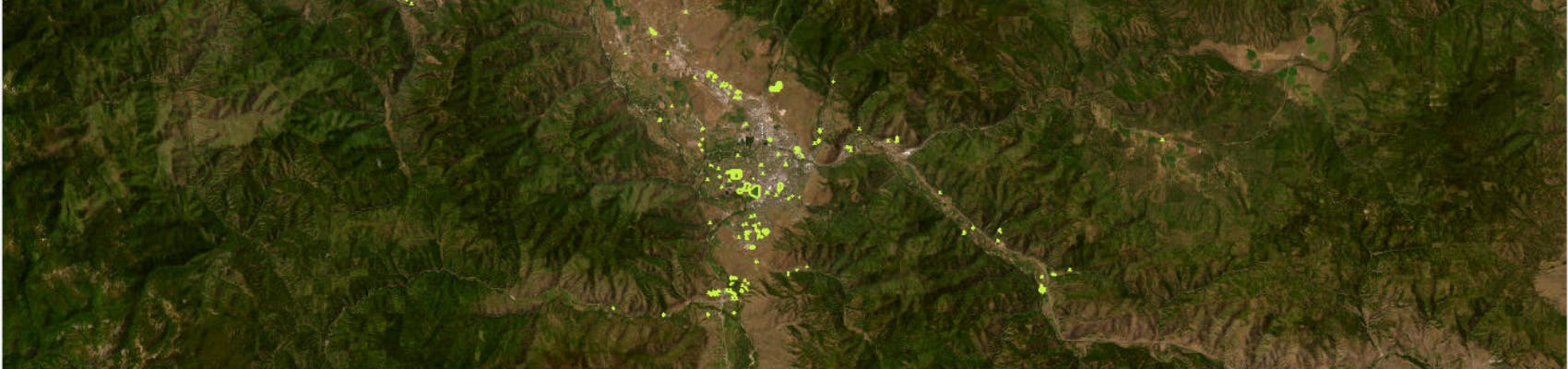
After reviewing over 260 parcels owned by Missoula County, LED staff worked with the Geographic Information Systems Department to create an interactive mapping tool to display all properties in a holistic and concise format to minimize both misinformation and fragmented debate.
Staff want to ensure the foundation of the project is solid before exploring recommendations. Explore the lands inventory map, read the project narrativeand give us your feedback on both the inventory tool and the assessments. The County will make updates based on suggestions from the community.
Once the tool is established, LED staff will use it to create strategic land use, management and policy recommendations for commissioner approval and staff implementation. However, no tool is perfect. Parcels within a sorted group will be reviewed carefully, and some parcels will likely be removed before that group is presented as a recommendation. We expect draft recommendations to be published late fall 2023.
Please keep in mind parcel boundaries for the Lands Inventory are drawn according to property ownership lines as designated in Montana Cadastral. Parcel boundaries may not be the same as the boundaries of parks, trails and other open space, which can extend across multiple property lines, both public and private.
The Department of Land and Economic Development (LED) was created in 2021 to implement strategic initiatives that enhance community vitality associated with economic growth throughout Missoula County as well as guide land development/redevelopment efforts for County properties. As one if its first initiatives, Missoula County commissioners assigned LED to conduct a holistic inventory and assessment of every County-owned property and provide them with strategic policy and use recommendations.
Staff collected factors on each property from a variety of sources to assess development suitability and address other questions about County-owned land. Because land is a finite natural resource, made especially scarce in our geographically constrained county, competition for the most “important” value and subsequent use can be fierce, and emotions can occasionally run high.
LED staff strived to be as objective as possible when choosing and evaluating factors, while seeking to honor previous engagement and planning efforts that articulated community values.
After reviewing over 260 parcels owned by Missoula County, LED staff worked with the Geographic Information Systems Department to create an interactive mapping tool to display all properties in a holistic and concise format to minimize both misinformation and fragmented debate.
Staff want to ensure the foundation of the project is solid before exploring recommendations. Explore the lands inventory map, read the project narrativeand give us your feedback on both the inventory tool and the assessments. The County will make updates based on suggestions from the community.
Once the tool is established, LED staff will use it to create strategic land use, management and policy recommendations for commissioner approval and staff implementation. However, no tool is perfect. Parcels within a sorted group will be reviewed carefully, and some parcels will likely be removed before that group is presented as a recommendation. We expect draft recommendations to be published late fall 2023.
Please keep in mind parcel boundaries for the Lands Inventory are drawn according to property ownership lines as designated in Montana Cadastral. Parcel boundaries may not be the same as the boundaries of parks, trails and other open space, which can extend across multiple property lines, both public and private.
Give us your feedback on the inventory and assessment. The County will make updates based on suggestions and new information from the community. Specifically, the County is looking for your answers to these questions:
1. Does the narrative explain the purpose of the project clearly?
2. Do you agree that the six areas assessed paint a full picture in a concise and simple format? If not, what should change?
3. Do you agree with individual parcel valuations?
4. Is the tool easy to navigate? How can it be improved?
5. What additional questions (narrative pg. 7) should we address in Phase II recommendations?
You need to be signed in to comment in this Guest Book.
You need to be signed in to comment in this Guest Book. Click here to Sign In or Register to get involved
I've only really looked at one Park on the map, Riverside Park in Lolo, and I can tell you that it's not accurately drawn. The Park extends downriver for between a half mile and one mile, well past the water treatment plant. There's a graded trail, it's regularly maintained, and a new bench was put in by a Boy Scouts-type group last year. None of that area is reflected in this map.
Charlie
About 3 years ago
1. Generally yes, see comments below There is discussion of using this tool to aid in decisions about acquiring land. I would be interested to see the narrative discuss this aspect of the tool further. There is a focus on affordable housing, but it seems that the real value of this tool is to identify the true value/direction for the property as defined by the citizens for the future. Processes are mentioned for “giving that land to the City of Missoula”, “… acquire and divest of property”, “… trade property”. Maybe the legal processes are not fully defined yet, but providing resources if processes are in place would be great, so we can understand what that process entails.
2. Yes, I cannot think of another criterion that aid in painting a picture of the citizens’ valuation of the property.
3. Yes and No. Topographical and Built Environment are quite objective and I have not seen any scores that I strongly disagree with. I think Administrative, Conservation, Recreation, and Cultural are much more subjective and need additional time to be reviewed by citizens. There are a number of properties in my immediate area that I believe need additional consideration to get a more accurate valuation from those impacted most. What will be the process for revising scores?
4. Yes the tool is easy to navigate. I think there are a couple areas that could be improved. There are many plans and policies that are listed under Project Process that contain maps which could be overlaid into the map tool to paint a more complete picture, set them up as layers that can be turned on and off. I am concerned that many previous plans have not been considered to this point and would impact the valuation of many properties. For reviewing the accuracy of the valuation I think it would be helpful to essentially create a paragraph that takes the scores and pastes the descriptions together. E.g. Lolo Water Station the paragraph would read “Parcel located within the floodplain, is too steep to build or serves a stormwater management purpose; size is not relevant. Parcel is designated as public right-of-way or has a utility easement. Parcel is necessary to conducting County operations, and operations extend county-wide, ranging from the Courthouse to gravel pits. Parcel has moderate natural resource, open space, wildlife habitat, agricultural or aesthetic value. Parcel has limited active or passive recreation value. Parcel does not promote the arts, heritage, education or human connection and has no historic significance.”
5. I think there is great value that this tool can be developed into as well. It may be good to add a future work section discussing how this will be used to help focus the County’s direction on whether to buy, sell, or hold a property; allocate more, less, or equal resources to the property as compared to the past; identify potential buyers/managers of the land; identifying potential properties to purchase and why using the six criterion.
Anders
About 3 years ago
Big Sky Park (all units) should have a conservation assessment value of 3. Conservation of this open space is extremely valuable as there are very few large undeveloped pieces of the Missoula valley floor left as open space. These parcels are heavily used for recreation, in large part because the character remains in a more natural state. As development and density increases in the orchard homes/target range area future generations will find this large open space with a natural character an incredible asset.
The unnamed parcel on the North Eastern flank of McCauley Butte should have a higher conservation, and recreational value assessment. This is the only piece of the butte that is under public ownership and is a very unique natural feature of the Missoula valley.
Mulberry park has the potential to become an important recreational/commuter trail connection along North ave, potentially connecting DNRC/Big Sky Park and Clements SUP with the city greenway system and the Bitterroot trail. The recreational value of this parcel should also be higher.
Nathan McLeod
About 3 years ago
Yes, the narrative clearly defines the purpose,and you've categorized the areas of usage well. While I have some disagreements with some valuations, I recognize that's subjective on my end. The mapping tool is an easy tool to navigate, but it could be improved to allow me to sort parcels and save that search. i.e. By being able to sort all the topographical valuations of "3", I could eliminate all the most difficult parcels to develop for housing and thereby narrow the possibilities to those parcels with the best opportunity, while noting that the other categories may hold value. The community can then convene, discuss, and weigh the trade-offs in a more informed manner.
Heather Harp
About 3 years ago
Personally I believe the open spaces should be left alone. Yes we need housing, but apartments aren’t the answer. Apartments are meant to address short term housing needs and the rent isn’t stable or too expensive (first, last and deposit just to move in). It’s okay for city to reach capacity and not develop every open space. If we develop everything we won’t have places to grow food. Leave these open spaces alone so wildlife has safe spaces to just be and just accept the fact Missoula is at capacity.
Malamutes4me
Over 3 years ago
Siesta Acres Map Link 6804 Siesta Dr , Missoula Size: 0.10 Ac This Acreage listed is incorrect. This parcel is closer to .96 Ac. Please check the COS for boundary measurements.
Missoula County Lands Inventory, Assessment and Strategic Plan has finished this stage
Review all County-owned parcels and determine what level of undertaking this project requires.
Create map and assess land
Missoula County Lands Inventory, Assessment and Strategic Plan has finished this stage
Establish factors for assessing properties. Create mapping tool to display and filter assessments. Draft narrative. Assess parcels in six primary areas.
Engagement on assessment
Missoula County Lands Inventory, Assessment and Strategic Plan has finished this stage
Publish narrative, mapping tool and assessment. Solicit feedback from the community. Edit narrative, mapping tool and assessment based on feedback.
Form recommendations
Missoula County Lands Inventory, Assessment and Strategic Plan is currently at this stage
Use mapping tool to filter parcels to make policy and land use and management recommendations. No tool is perfect. Some properties will likely be removed from groups before recommendations are brought forward.
Engagement on recommendations
this is an upcoming stage for Missoula County Lands Inventory, Assessment and Strategic Plan
Publish draft recommendations. Solicit feedback from the community. Edit the recommendations based on community feedback.
Implementation
this is an upcoming stage for Missoula County Lands Inventory, Assessment and Strategic Plan
If the Board of County Commissioners adopts the recommendations and direct staff to implement them, staff would draft policies as well as land use and management recommendations for the commission’s further approval.


I've only really looked at one Park on the map, Riverside Park in Lolo, and I can tell you that it's not accurately drawn. The Park extends downriver for between a half mile and one mile, well past the water treatment plant. There's a graded trail, it's regularly maintained, and a new bench was put in by a Boy Scouts-type group last year. None of that area is reflected in this map.
1. Generally yes, see comments below
There is discussion of using this tool to aid in decisions about acquiring land. I would be interested to see the narrative discuss this aspect of the tool further.
There is a focus on affordable housing, but it seems that the real value of this tool is to identify the true value/direction for the property as defined by the citizens for the future.
Processes are mentioned for “giving that land to the City of Missoula”, “… acquire and divest of property”, “… trade property”. Maybe the legal processes are not fully defined yet, but providing resources if processes are in place would be great, so we can understand what that process entails.
2. Yes, I cannot think of another criterion that aid in painting a picture of the citizens’ valuation of the property.
3. Yes and No. Topographical and Built Environment are quite objective and I have not seen any scores that I strongly disagree with. I think Administrative, Conservation, Recreation, and Cultural are much more subjective and need additional time to be reviewed by citizens. There are a number of properties in my immediate area that I believe need additional consideration to get a more accurate valuation from those impacted most. What will be the process for revising scores?
4. Yes the tool is easy to navigate. I think there are a couple areas that could be improved.
There are many plans and policies that are listed under Project Process that contain maps which could be overlaid into the map tool to paint a more complete picture, set them up as layers that can be turned on and off. I am concerned that many previous plans have not been considered to this point and would impact the valuation of many properties.
For reviewing the accuracy of the valuation I think it would be helpful to essentially create a paragraph that takes the scores and pastes the descriptions together. E.g. Lolo Water Station the paragraph would read “Parcel located within the floodplain, is too steep to build or serves a stormwater management purpose; size is not relevant. Parcel is designated as public right-of-way or has a utility easement. Parcel is necessary to conducting County operations, and operations extend county-wide, ranging from the Courthouse to gravel pits. Parcel has moderate natural resource, open space, wildlife habitat, agricultural or aesthetic value. Parcel has limited active or passive recreation value. Parcel does not promote the arts, heritage, education or human connection and has no historic significance.”
5. I think there is great value that this tool can be developed into as well. It may be good to add a future work section discussing how this will be used to help focus the County’s direction on whether to buy, sell, or hold a property; allocate more, less, or equal resources to the property as compared to the past; identify potential buyers/managers of the land; identifying potential properties to purchase and why using the six criterion.
Big Sky Park (all units) should have a conservation assessment value of 3. Conservation of this open space is extremely valuable as there are very few large undeveloped pieces of the Missoula valley floor left as open space. These parcels are heavily used for recreation, in large part because the character remains in a more natural state. As development and density increases in the orchard homes/target range area future generations will find this large open space with a natural character an incredible asset.
The unnamed parcel on the North Eastern flank of McCauley Butte should have a higher conservation, and recreational value assessment. This is the only piece of the butte that is under public ownership and is a very unique natural feature of the Missoula valley.
Mulberry park has the potential to become an important recreational/commuter trail connection along North ave, potentially connecting DNRC/Big Sky Park and Clements SUP with the city greenway system and the Bitterroot trail. The recreational value of this parcel should also be higher.
Yes, the narrative clearly defines the purpose,and you've categorized the areas of usage well.
While I have some disagreements with some valuations, I recognize that's subjective on my end.
The mapping tool is an easy tool to navigate, but it could be improved to allow me to sort parcels and save that search. i.e. By being able to sort all the topographical valuations of "3", I could eliminate all the most difficult parcels to develop for housing and thereby narrow the possibilities to those parcels with the best opportunity, while noting that the other categories may hold value. The community can then convene, discuss, and weigh the trade-offs in a more informed manner.
Personally I believe the open spaces should be left alone. Yes we need housing, but apartments aren’t the answer. Apartments are meant to address short term housing needs and the rent isn’t stable or too expensive (first, last and deposit just to move in). It’s okay for city to reach capacity and not develop every open space. If we develop everything we won’t have places to grow food. Leave these open spaces alone so wildlife has safe spaces to just be and just accept the fact Missoula is at capacity.
Siesta Acres
Map Link
6804 Siesta Dr , Missoula
Size: 0.10 Ac
This Acreage listed is incorrect. This parcel is closer to .96 Ac. Please check the COS for boundary measurements.