Missoula County Lands Inventory, Assessment and Strategic Plan
Explore the lands inventory map, read the project narrative and give us your feedback on the inventory and assessment. The County will make updates based on suggestions from the community.
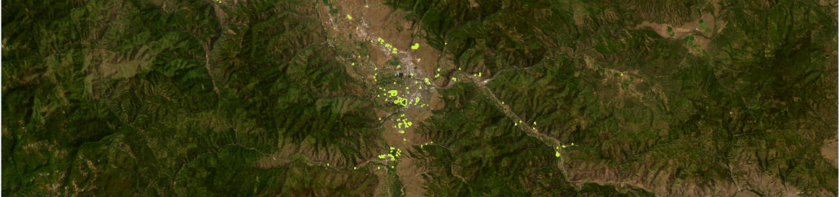
The Department of Land and Economic Development (LED) was created in 2021 to implement strategic initiatives that enhance community vitality associated with economic growth throughout Missoula County as well as guide land development/redevelopment efforts for County properties. As one if its first initiatives, Missoula County commissioners assigned LED to conduct a holistic inventory and assessment of every County-owned property and provide them with strategic policy and use recommendations.
Staff collected factors on each property from a variety of sources to assess development suitability and address other questions about County-owned land. Because land is a finite natural resource, made especially scarce in our geographically constrained county, competition for the most “important” value and subsequent use can be fierce, and emotions can occasionally run high.
LED staff strived to be as objective as possible when choosing and evaluating factors, while seeking to honor previous engagement and planning efforts that articulated community values.
After reviewing over 260 parcels owned by Missoula County, LED staff worked with the Geographic Information Systems Department to create an interactive mapping tool to display all properties in a holistic and concise format to minimize both misinformation and fragmented debate.
Staff want to ensure the foundation of the project is solid before exploring recommendations. Explore the lands inventory map, read the project narrative and give us your feedback on both the inventory tool and the assessments. The County will make updates based on suggestions from the community.
Once the tool is established, LED staff will use it to create strategic land use, management and policy recommendations for commissioner approval and staff implementation. However, no tool is perfect. Parcels within a sorted group will be reviewed carefully, and some parcels will likely be removed before that group is presented as a recommendation. We expect draft recommendations to be published late fall 2023.
Please keep in mind parcel boundaries for the Lands Inventory are drawn according to property ownership lines as designated in Montana Cadastral. Parcel boundaries may not be the same as the boundaries of parks, trails and other open space, which can extend across multiple property lines, both public and private.
Send us your questions!
Have questions about the inventory and assessment? Let us know! We will try to respond within five business days.
You can also take a look under the "Frequently Asked Questions" section to see if your question has already been answered.
Who's Listening
-

Phone 406-258-3175 -

Phone 406-258-3707 -

Phone 406-258-3444


Thank you for your contribution!
Help us reach out to more people in the community
Share this with family and friends