Development Projects
Let us know your thoughts on private development projects happening in Missoula County.
Missoula County routinely considers development projects such as subdivisions, family transfers, boundary line relocations and rezoning requests. The projects featured on this page first come to the Planning, Development and Sustainability Department to ensure they meet various requirements related to zoning, land use, floodplain and other regulations. The Board of County Commissioners or the relevant decision-making body then considers approval of projects at their public meetings.
Comments on these projects help planning staff more accurately present to the commissioners how the community feels about the proposals, so the commissioners can make well-informed decisions on each project.
-
O'Keefe Ranch Estates Subdivision - Landscaping Condition Amendment (Wye)
Share O'Keefe Ranch Estates Subdivision - Landscaping Condition Amendment (Wye) on Facebook Share O'Keefe Ranch Estates Subdivision - Landscaping Condition Amendment (Wye) on X (formerly Twitter) Share O'Keefe Ranch Estates Subdivision - Landscaping Condition Amendment (Wye) on Linkedin Email O'Keefe Ranch Estates Subdivision - Landscaping Condition Amendment (Wye) linkProject Description:
The developer of the O’Keefe Ranch Estates Subdivision, located in the Wye area of Missoula County, requests to amend Subdivision Condition of Approval #14 by proposing xeriscaping instead of seeded grass in the common area strips in Phase 3 of the subdivision. Section 6.7 of the Missoula County Subdivision Regulations allows the request for modest changes to the conditions of approval for a filed plat.

Xeriscaping is the practice of designing landscapes to reduce or eliminate the need for irrigation (aside from drip lines) and what the natural climate provides. The proposal will adhere to the approved landscaping guidelines in the regulations. This includes a 5-foot-wide asphalt path and commercial irrigation system in the 20-foot-wide common area strips, subject to review and approval by the Planning, Development and Sustainability and the Missoula County Department of Ecology and Extension departments.
O’Keefe Ranch Estates Subdivision was originally approved by county commissioners in 2005, subject to 27 conditions of approval. It was approved as an eight-phase subdivision with Phase 1 filed in 2022, Phase 2 filed in 2023, and Phase 3 filed in 2025. Phases 4-8 have final plat deadlines between 2028 and 2031.
Project Timeline:
County commissioners hearing: Thursday, Jan. 29, 2 p.m.
- In-person location: Sophie Moiese Room, Missoula County Courthouse Annex, 200 West Broadway, Missoula
- Virtual option: Residents can attend the meeting via Microsoft Teams. To join the call on your phone, call 406-272-4824, Conference ID 467 457 758#. To join the meeting on your device, follow the links on the agenda that will be published at http://missoula.co/bccmeetings
Public Comment:
Submit public comment by using the comment tool below.
Project Lead:
Kevin Dantic, 406-258-4652
Important Links and Documents:
O’Keefe Ranch Estates Subdivision Application
-
Nordberg Family Transfer Exemption (Bonner)
Share Nordberg Family Transfer Exemption (Bonner) on Facebook Share Nordberg Family Transfer Exemption (Bonner) on X (formerly Twitter) Share Nordberg Family Transfer Exemption (Bonner) on Linkedin Email Nordberg Family Transfer Exemption (Bonner) linkProject Description:
Jason Nordberg is requesting to use the family transfer exemption from subdivision review to divide his current 20-acre property in Bonner into two 10-acre tracts. The property does not have an address but is located between Red Tail Road and Mystic Moon road.
Jason plans to gift both lots to his wife, Jennifer Nordberg. Jennifer plans to transfer both lots to their two children when they turn 18. Jason and Jennifer will continue to live at 650 Mystic Moon Road, which is one lot over from the family transfer parcel.

Subdivision Regulations and Exemptions
Missoula County’s subdivision regulations promote public health, safety and general welfare by ensuring any subdivision of land in the County’s jurisdiction provides for adequate light, air, water supply, sewage disposal, parks and recreation areas, ingress and egress and other public requirements. Many requests to divide land must go through the subdivision process to ensure these requirements are met, but certain types of land division are exempt from subdivision review. Landowners can apply for one or multiple subdivision exemptions when their development plans meet the state and local requirements for the applicable exemptions.
Being granted these exemptions means the property owner does not need to go through the standard subdivision review process to divide their property. These requests require administrative review by planning staff and, in some cases, may require approval by the county commissioners to ensure the applicant is not evading these regulations.
Family Transfer Exemption
Landowners can request a family transfer exemption when they intend to divide their property to gift or sell the newly created parcel(s) to an immediate family member.
What is a family transfer?
Montana law specifically allows landowners to divide land and gift or sell one parcel per immediate family member (like a child, parent or spouse), without full subdivision review.
Requests for family transfers must always come before the commissioners. Missoula County considers dozens of family land transfers every year. It’s not rare — other counties across Montana regularly process these applications too. It’s not a loophole — it’s in the law for a reason: to help families live near each other or pass down land. It’s does not skirt regulations — the process requires surveys, documentation, fees and approval by county commissioners.
The landowner and recipient must be real people, not LLCs or corporations. It can only be used once per family member per county.
Project Timeline:
County commissioners hearing: Thursday, Feb. 12, 2 p.m.
In-person location: Sophie Moiese Room, Missoula County Courthouse Annex, 200 West Broadway, Missoula
Virtual option: Residents can attend the meeting via Microsoft Teams. To join the call on your phone, call 406-272-4824, Conference ID 467 457 758#. To join the meeting on your device, follow the links on the agenda that will be published at http://missoula.co/bccmeetings
Public Comment:
Submit public comment by using the comment tool below.
Project Lead:
Katy Reeder, kreeder@missoulacounty.us
Important Links and Documents:
-
Hoyer Family Transfer Exemption (Frenchtown)
Share Hoyer Family Transfer Exemption (Frenchtown) on Facebook Share Hoyer Family Transfer Exemption (Frenchtown) on X (formerly Twitter) Share Hoyer Family Transfer Exemption (Frenchtown) on Linkedin Email Hoyer Family Transfer Exemption (Frenchtown) linkThe Hoyer family transfer has been postponed to Jan. 29 at 2 p.m.
Project Description:
Julie Hoyer is requesting to use the family transfer exemption from subdivision review to divide her current 1.43-acre property at 17500 Mullan Rd. (south of the canal right-of-way) in Frenchtown into two tracts.
Julie plans to gift a 0.87-acre tract to her son, Shawn Michael Durham, and keep the remaining 0.56-acre tract as a primary residence for her and her husband, Carl.

Subdivision Regulations and Exemptions:
Missoula County’s subdivision regulations promote public health, safety and general welfare by ensuring any subdivision of land in the County’s jurisdiction provides for adequate light, air, water supply, sewage disposal, parks and recreation areas, ingress and egress and other public requirements. Many requests to divide land must go through the subdivision process to ensure these requirements are met, but certain types of land division are exempt from subdivision review. Landowners can apply for one or multiple subdivision exemptions when their development plans meet the state and local requirements for the applicable exemptions.
Being granted these exemptions means the property owner does not need to go through the standard subdivision review process to divide their property. These requests require administrative review by planning staff and, in some cases, may require approval by the county commissioners to ensure the applicant is not evading these regulations.
- Family Transfer Exemption
Landowners can request a family transfer exemption when they intend to divide their property to gift or sell the newly created parcel(s) to an immediate family member.
View subdivision exemption criteria.
What is a family transfer?
Montana law specifically allows landowners to divide land and gift or sell one parcel per immediate family member (like a child, parent or spouse), without full subdivision review.
Requests for family transfers must always come before the commissioners. Missoula County considers dozens of family land transfers every year. It’s not rare — other counties across Montana regularly process these applications too. It’s not a loophole — it’s in the law for a reason: to help families live near each other or pass down land. It does not skirt regulations — the process requires surveys, documentation, fees and approval by county commissioners.
The landowner and recipient must be real people, not LLCs or corporations. It can only be used once per family member per county.
Project Timeline:
County commissioners hearing: Thursday, Jan. 29, 2 p.m.
- In-person location: Sophie Moiese Room, Missoula County Courthouse Annex, 200 West Broadway, Missoula
- Virtual option: Residents can attend the meeting via Microsoft Teams. To join the call on your phone, call 406-272-4824, Conference ID 467 457 758#. To join the meeting on your device, follow the links on the agenda that will be published at http://missoula.co/bccmeetings
Public Comment:
Submit public comment by using the comment tool below.
Project Lead:
Patrick Swart, pswart@missoulacounty.us
Important Links and Documents:
- Family Transfer Exemption
-
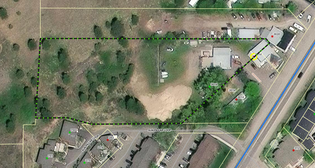
Ram Addition Subdivision Plat Adjustment (Wye)
Share Ram Addition Subdivision Plat Adjustment (Wye) on Facebook Share Ram Addition Subdivision Plat Adjustment (Wye) on X (formerly Twitter) Share Ram Addition Subdivision Plat Adjustment (Wye) on Linkedin Email Ram Addition Subdivision Plat Adjustment (Wye) link
Project Background:
The developer of the Ram Addition Subdivision at an unaddressed parcel (geocode:04-2325-21-1-01-02-0000) in the Wye area, is requesting a plat adjustment to vacate a 20-foot drainage easement located within Lot 2 of the Ram Addition. The easement bisects the property, and limits development potential. All other subdivision protections, utility easements, and public improvements will remain intact. Any stormwater requirements for future development will be addressed through updated Certificate of Subdivision Approval review and site-specific engineering consistent with state Department of Environmental Quality and County standards.
Project Timeline:
Thursday, Jan. 29, 2 p.m.: county commissioners’ public meeting
- In-person location: Sophie Moiese Room, Missoula County Courthouse Annex, 200 West Broadway, Missoula
- Virtual option: Residents can attend the meeting via Microsoft Teams. To join the call on your phone, call 406-272-4824, Conference ID 467 457 758#. To join the meeting on your device, follow the links on the agenda that will be published at http://missoula.co/bccmeetings
Public Comment:
Submit public comment by using the comment tool below.
Project Lead:
Katy Reeder, 406-258-3707
Important Links and Documents:
 1 comment
-
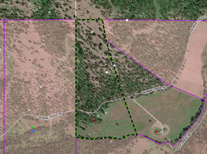
Gilman Creek Road Administrative Appeal
Share Gilman Creek Road Administrative Appeal on Facebook Share Gilman Creek Road Administrative Appeal on X (formerly Twitter) Share Gilman Creek Road Administrative Appeal on Linkedin Email Gilman Creek Road Administrative Appeal link
Project Background:
Arrowleaf Gulch LLC and Cameron and Faith Schmitz have submitted an appeal of an administrative decision (Land Use and Zoning Compliance Permit LZ25059311) for the property located at 20843 Gilman Creek Road, west of Missoula, owned by Kee Holdings LLC. Missoula County PDS staff interpreted that the uses proposed on the permit, a disc golf course and summer camp/outdoor retreat, were in harmony with the allowed uses in the zoning district, as those uses, classified by staff as Recreation, Developed Outdoor, were found to capitalize on the natural landscape. The appealing party seeks to reclassify the uses as “Recreation, Commercial Outdoor” and “Entertainment Venues (small, medium, and large),” which are not allowed in the AGW zoning district. Under the proposed re-classification, some current uses of the property would be prohibited.
Project Timeline:
Board of Adjustment Hearing: Wednesday, Dec. 17, 6 p.m.
- In-person location: 200 W. Broadway, Missoula County Courthouse, Sophie Moiese Room
- Virtual option: Residents can attend the meeting via Microsoft Teams. To join the meeting on your device, follow the links on the agenda that will be published on the Zoning Board of Adjustment page at http://missoula.co/boameetings.
This project is not subject to review by the Board of County Commissioners.
Public Comment:
Submit public comment by using the comment tool below.
Project Lead:
Kevin Dantic, 406-258-4652
Important Links and Documents:
Gilman Creek Road Appeal Application
Gilman Creek Road Issued Permit
Planning, Development and Sustainability
-
Ployhar Family Transfer Exemption (Greenough & Potomac)
Share Ployhar Family Transfer Exemption (Greenough & Potomac) on Facebook Share Ployhar Family Transfer Exemption (Greenough & Potomac) on X (formerly Twitter) Share Ployhar Family Transfer Exemption (Greenough & Potomac) on Linkedin Email Ployhar Family Transfer Exemption (Greenough & Potomac) linkProject Description:
John Ployhar is requesting to use the family transfer exemption from subdivision review to divide his 80-acre property at 3225 Swanson Lane in the Potomac area into three tracts (Lot A: 38.62 acres; Lot B: 21.04 acres; Lot C: 20.34). John plans to gift Lot B and Lot C to his two daughters and keep Lot A. Lot B and Lot C will be kept in a trust until the daughters turn 18.

Subdivision Regulations and Exemptions
Missoula County’s subdivision regulations promote public health, safety and general welfare by ensuring any subdivision of land in the County’s jurisdiction provides for adequate light, air, water supply, sewage disposal, parks and recreation areas, ingress and egress and other public requirements. Many requests to divide land must go through the subdivision process to ensure these requirements are met, but certain types of land division are exempt from subdivision review. Landowners can apply for one or multiple subdivision exemptions when their development plans meet the state and local requirements for the applicable exemptions.
Being granted these exemptions means the property owner does not need to go through the standard subdivision review process to divide their property. These requests require administrative review by planning staff and, in some cases, may require approval by the county commissioners to ensure the applicant is not evading these regulations.
Family Transfer Exemption
Landowners can request a family transfer exemption when they intend to divide their property to gift or sell the newly created parcel(s) to an immediate family member.
What is a family transfer?
Montana law specifically allows landowners to divide land and gift or sell one parcel per immediate family member (like a child, parent or spouse), without full subdivision review.
Requests for family transfers must always come before the commissioners. Missoula County considers dozens of family land transfers every year. It’s not rare — other counties across Montana regularly process these applications too. It’s not a loophole — it’s in the law for a reason: to help families live near each other or pass down land. It’s does not skirt regulations — the process requires surveys, documentation, fees and approval by county commissioners.
The landowner and recipient must be real people, not LLCs or corporations. It can only be used once per family member per county.
Project Timeline:
County commissioners hearing: Thursday, Dec. 4, 2 p.m.
In-person location: Sophie Moiese Room, Missoula County Courthouse Annex, 200 West Broadway, Missoula
Virtual option: Residents can attend the meeting via Microsoft Teams. To join the call on your phone, call 406-272-4824, Conference ID 467 457 758#. To join the meeting on your device, follow the links on the agenda that will be published at http://missoula.co/bccmeetings
Public Comment:
Submit public comment by using the comment tool below.
Project Lead:
Katy Reeder, 406-258-3707
Important Links and Documents:
-
Special Exception Request at 3507 S 7th St. W (Orchard Homes)
Share Special Exception Request at 3507 S 7th St. W (Orchard Homes) on Facebook Share Special Exception Request at 3507 S 7th St. W (Orchard Homes) on X (formerly Twitter) Share Special Exception Request at 3507 S 7th St. W (Orchard Homes) on Linkedin Email Special Exception Request at 3507 S 7th St. W (Orchard Homes) link
Project Background:
Josh Slotnick and Kimberly Murchinson are requesting a special exception to build a second single-family home on their 2.96-acre property at 3507 S 7th St. W. in the Orchard Homes neighborhood. The property is currently zoned Rural Residential, Small Agriculture (RRS 1), which does not permit a second single-family home under the Missoula County Zoning Regulations.
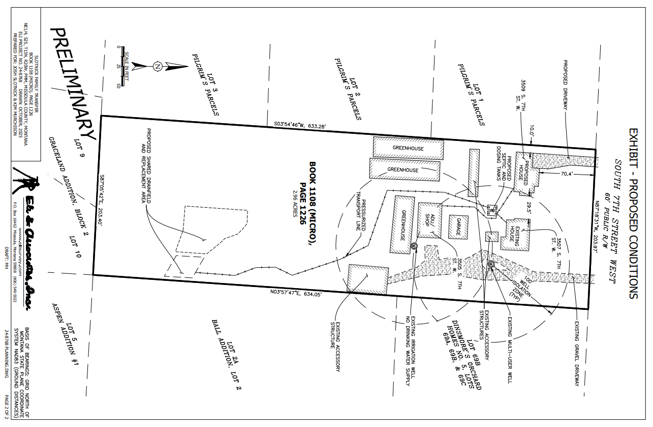
This property is currently associated with a family transfer. The proposed second home will be located on this separate lot. The property owners are pursuing a special exception at this stage because the family transfer cannot be filed until a sanitation review is finalized. Given that the sanitation review process may take several months, the property owners are seeking to initiate construction of the second home while construction equipment is on site for the installation of a new shared septic system, which is currently in the permitting stage with Missoula Public Health.
Project Timeline:
Board of Adjustment Public Hearing: Wednesday, Nov. 19, 6 p.m.
- In-person location: 200 W. Broadway, Missoula County Courthouse, Sophie Moiese Room
- Virtual option: Residents can attend the meeting via Microsoft Teams. To join the meeting on your device, follow the links on the agenda that will be published on the Zoning Board of Adjustment page at http://missoula.co/boameetings.
This project is not subject to review by the Board of County Commissioners. Josh Slotnick is a current county commissioner but is not involved in the approval process for this request.
Project Lead:
Kevin Dantic, 406-258-4652, kdantic@missoulacounty.us
Related Links & Documents:
3507 S 7th St. W Special Exception Application
-
Special Exception Request at 3614 Hwy 200 (East Missoula)
Share Special Exception Request at 3614 Hwy 200 (East Missoula) on Facebook Share Special Exception Request at 3614 Hwy 200 (East Missoula) on X (formerly Twitter) Share Special Exception Request at 3614 Hwy 200 (East Missoula) on Linkedin Email Special Exception Request at 3614 Hwy 200 (East Missoula) linkProject Background:
Sunsup LLC is requesting a special exception for a mixed-use project at 3614 Hwy 200 in East Missoula that combines multi-family residential units with small business commercial spaces.
Portions of this development will be built on the east side of Mount Jumbo, which has slopes greater than 10% and requires adherence to Missoula County’s hillside and ridgeline development standards. Part of the proposed development also occurs on slopes greater than 25% which requires special exception, along with a complete geotechnical analysis prepared by a professional engineer licensed to practice in Montana. In addition to meeting this requirement, the applicant must also demonstrate the following:
- The development will not result in accelerated erosion or create hazardous conditions on the site or nearby property. This can be demonstrated by an erosion and sediment control plan with supporting evidence.
- The applicant considered and evaluated all alternative locations for the development (including structures, buildings and retaining walls, roads, and driveways, parking areas and other infrastructure) on non-steep slopes (less than 10%) and can demonstrate these locations are either inappropriate or infeasible.
- Confirm that surface runoff will not create unstable conditions using appropriate stormwater management facilities. If such facilities do not exist, the developer must construct one.
Project Timeline:
Board of Adjustment Public Hearing: Wednesday, Dec. 17, 6 p.m.
- In-person location: 200 W. Broadway, Missoula County Courthouse, Sophie Moiese Room
- Virtual option: Residents can attend the meeting via Microsoft Teams. To join the meeting on your device, follow the links on the agenda that will be published on the Zoning Board of Adjustment page at http://missoula.co/boameetings.
This project is not subject to review by the Board of County Commissioners.
Project Lead:
Kathleen Arthur, 406-258-3429
Tim Worley, 406-258-4794
Related Links & Documents:
-
Sign Variance – 505 Highton St. (East Missoula)
Share Sign Variance – 505 Highton St. (East Missoula) on Facebook Share Sign Variance – 505 Highton St. (East Missoula) on X (formerly Twitter) Share Sign Variance – 505 Highton St. (East Missoula) on Linkedin Email Sign Variance – 505 Highton St. (East Missoula) linkProject Background:
Jagpreet Ghuman (Bobby) is requesting a sign variance for the property, Jay’s One Stop, located at 505 Highton St. in East Missoula. The property currently has a gas station, convenience store, takeout restaurant, laundromat, and a future tenant.
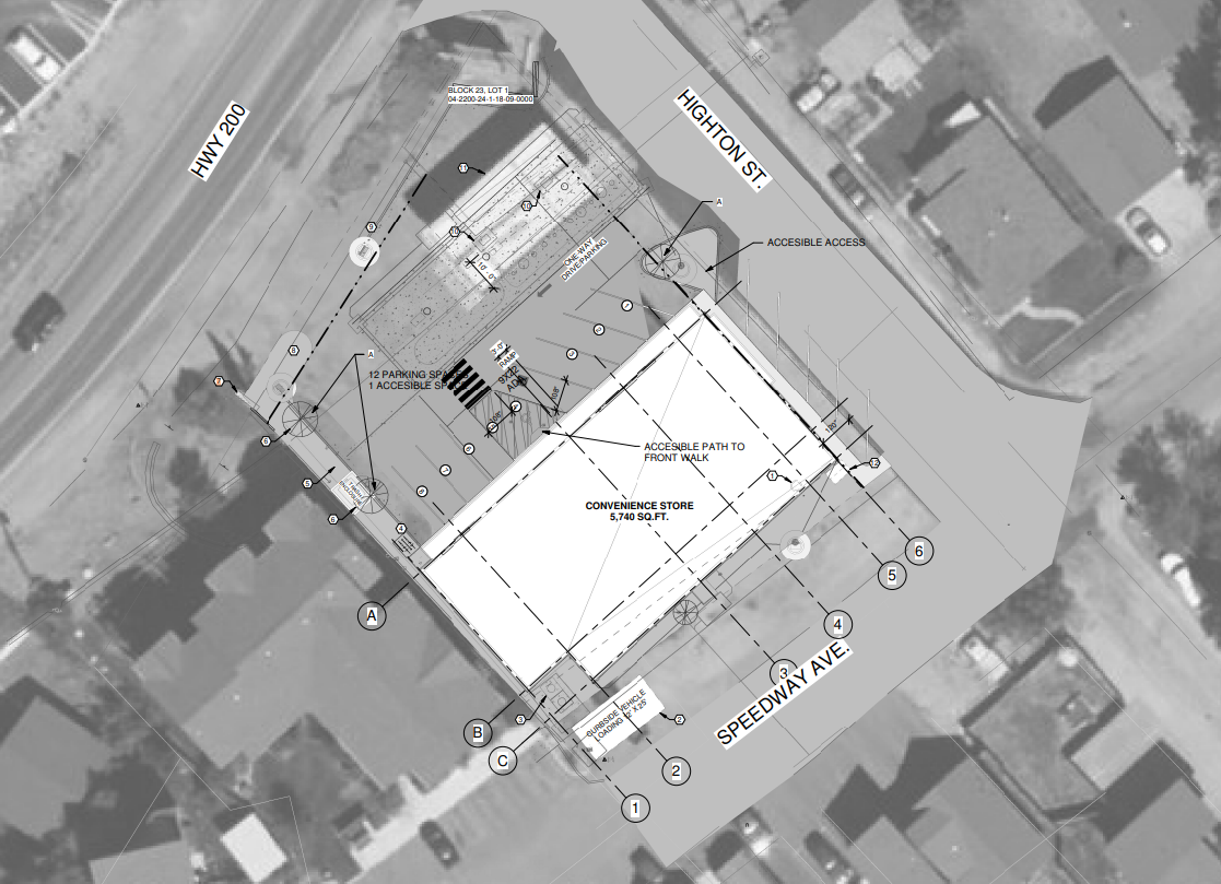
The request is to structurally alter an existing nonconforming pole sign to accommodate the following variances:
- A variance to expand the sign face beyond the 24 square feet
- A variance to adjust the minimum sign clearance from 8 feet down to 7.5 feet.
The proposed sign face addition and the change to the minimum sign clearance would mean the sign would no longer conform with Neighborhood Center Zoning sign regulations. The current sign standards for Neighborhood Center Zoning allow one pole sign per lot frontage with a maximum height of 12 feet, a minimum sign clearance of 8 feet, and a maximum sign face area of 24 feet.
Since the pole sign was established before the adoption of the 2022 sign regulations, it was allowed to exist even though it does not conform with the regulations, with the understanding that any changes beyond normal maintenance and upkeep would require a variance from the Missoula County Board of Adjustment.
Missoula County Sign Regulations:
What is a variance?
A variance is a relaxation of specific provisions of zoning regulations that can be granted if certain criteria can be met. The Board of Adjustment may only approve a zoning variance if it’s not contrary to the public interest and does not give an advantage to a particular business that is not also enjoyed by other businesses in the same zoning district. They must evaluate proposed variances using the following criteria and find favorably that:
- The variance will not authorize a use that is not already allowed in the zoning district.
- The variance will not authorize additional density beyond what is allowed in the zoning district.
- Special conditions exist that are unique to the property, such as size, shape, topography or location, that do not apply to other lands in the same zoning classification.
- Literal enforcement of the provisions of the regulations will result in unnecessary hardship that is not of the applicant’s own making.
- Granting the variance will be in harmony with the general purpose and intent of these regulations and the Missoula County Growth Policy and will not be injurious to the neighborhood or otherwise detrimental to the public welfare.
- The request for the variance is not based on monetary factors.
Project Timeline:
Board of Adjustment Public Hearing: Wednesday, Nov. 19, 6 p.m.
- In-person location: 200 W. Broadway, Missoula County Courthouse, Sophie Moiese Room
- Virtual option: Residents can attend the meeting via Microsoft Teams. To join the meeting on your device, follow the links on the agenda that will be published on the Zoning Board of Adjustment page at http://missoula.co/boameetings.
This project is not subject to review by the Board of County Commissioners.
Project Lead:
Patrick Swart, 406-258-4841, pswart@missoulacounty.us
Related Links & Documents:
-
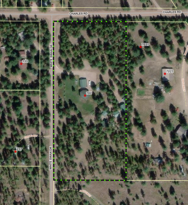
Schuff Family Transfer Exemption (Condon)
Share Schuff Family Transfer Exemption (Condon) on Facebook Share Schuff Family Transfer Exemption (Condon) on X (formerly Twitter) Share Schuff Family Transfer Exemption (Condon) on Linkedin Email Schuff Family Transfer Exemption (Condon) linkProject Description:
Linda and Michael Schuff are requesting to use the family transfer exemption from subdivision review to divide their 5-acre property at 160 White Swan Drive in Condon into two tracts (Lot 2-A: 1 acre; Lot 2-B: 4 acres). The Schuffs plan to gift Lot 2-A to their daughter, Angela Beckstrom, and keep Lot 2-B as their primary residence. Their daughter Angela plans to build a new house on Lot 2-A.
Subdivision Regulations and Exemptions:
Missoula County’s subdivision regulations promote public health, safety and general welfare by ensuring any subdivision of land in the County’s jurisdiction provides for adequate light, air, water supply, sewage disposal, parks and recreation areas, ingress and egress and other public requirements. Many requests to divide land must go through the subdivision process to ensure these requirements are met, but certain types of land division are exempt from subdivision review. Landowners can apply for one or multiple subdivision exemptions when their development plans meet the state and local requirements for the applicable exemptions.
Being granted these exemptions means the property owner does not need to go through the standard subdivision review process to divide their property. These requests require administrative review by planning staff and, in some cases, may require approval by the county commissioners to ensure the applicant is not evading these regulations.
Family Transfer Exemption
Landowners can request a family transfer exemption when they intend to divide their property to gift or sell the newly created parcel(s) to an immediate family member.
What is a family transfer?
Montana law specifically allows landowners to divide land and gift or sell one parcel per immediate family member (like a child, parent or spouse), without full subdivision review.
Requests for family transfers must always come before the commissioners. Missoula County considers dozens of family land transfers every year. It’s not rare — other counties across Montana regularly process these applications too. It’s not a loophole — it’s in the law for a reason: to help families live near each other or pass down land. It does not skirt regulations — the process requires surveys, documentation, fees and approval by county commissioners.
The landowner and recipient must be real people, not LLCs or corporations. It can only be used once per family member per county.
Project Timeline:
County commissioners hearing: Thursday, Nov. 13, 2 p.m.
In-person location: Sophie Moiese Room, Missoula County Courthouse Annex, 200 West Broadway, Missoula
Virtual option: Residents can attend the meeting via Microsoft Teams. To join the call on your phone, call 406-272-4824, Conference ID 467 457 758#. To join the meeting on your device, follow the links on the agenda that will be published at http://missoula.co/bccmeetings
Public Comment:
Submit public comment by using the comment tool below.
Project Lead:
Katy Reeder, 406-258-3707, kreeder@missoulacounty.us
Important Links and Documents:
 1 comment
Who's Listening
-

Phone 406-258-4794 -
Planner III/Floodplain Administrator
Missoula County Planning, Development and Sustainability

Phone 406-258-3799 -

Phone 406-258-4946 -
Phone 406-258-3425 -

Phone 406-258-3706 Email lryan@missoulacounty.us -

Phone 406-258-4841 -

Phone 406-258-4652 -

Phone 406-258-3707
Important Documents
-
 Shoreline Permit & Variance Application #25-06
-
 0 Cover letter.docx (22.5 KB) (docx)
-
1 County Shoreline Construction Permit.pdf (410 KB) (pdf)
-
2 DCI Engineering Shoreline Restoration letter.docx (203 KB) (docx)
-
3 County Shoreline Restoration Application Addendum.docx (46 KB) (docx)
-
4 Linford Colgan Vicinity Map.docx (257 KB) (docx)
-
5 Seeley Lake Shore Sites COS 53653.pdf (725 KB) (pdf)
-
6 Seeley Lake Shore Sites COS 53653 Enlarged.docx (316 KB) (docx)
-
7 Lots 78 80 82 Retracement COS 6242 2010.pdf (108 KB) (pdf)
-
8 Existing Conditions Photos.docx (1.22 MB) (docx)
-
9 Project Area Map.docx (1.17 MB) (docx)
-
10 MTNHWRD Map.docx (291 KB) (docx)
-
11 Site Plan Diagram.pdf (168 KB) (pdf)
-
12 Site Plan Cross Section Diagram.pdf (475 KB) (pdf)
-
13 Restoration Erosion Sed Runoff Plan Diagram.pdf (159 KB) (pdf)
-
14 Lakeside Interface Berm Diagram.pdf (166 KB) (pdf)
-
15 County Shoreline Permit Variance Request.docx (33.3 KB) (docx)
-
16 County Shoreline Restoration Application Project Impact Assessment.docx (52.5 KB) (docx)
-
2025_10_22 FACTS ACK_MTB013622_20062.PDF (179 KB) (PDF)
-
2025_10_22 FACTS APP_MTB013622_20062.PDF (309 KB) (PDF)
-
2025_10_29 FACTS permit AUTH_MTB013622_20062.PDF (192 KB) (PDF)
-
2026_01_05 cover letter for permit.pdf (429 KB) (pdf)
-
LUL Application Form .doc (128 KB) (doc)
-
navigable river license dnrc.pdf (1.94 MB) (pdf)
-
1 2021_NWP-13-FS_links.pdf (348 KB) (pdf)
-
1 20200219_SLOPES renewal_AppE_Conservation Measures.pdf (141 KB) (pdf)
-
1 Certification of Compliance.pdf (54.9 KB) (pdf)
-
1 Permit Verification.pdf (270 KB) (pdf)
-
1 SLOPES PROJECT COMPLETION REPORT FORM.docx (25.6 KB) (docx)
-
2026_05_20 404 permit update.docx (21.6 KB) (docx)
-
-
Blackfoot Crossing Project
-
01_Growth Policy Amendment Request2.0.pdf (739 KB) (pdf)
-
02_Zoning Amendment Application.pdf (317 KB) (pdf)
-
03_Existing Land Use.pdf (518 KB) (pdf)
-
04_Proposed Land Use.pdf (532 KB) (pdf)
-
05_Working Lands Land Use.pdf (383 KB) (pdf)
-
06_Open Resource and Recreation Land Use.pdf (383 KB) (pdf)
-
07_Neighborhood Center Land Use.pdf (368 KB) (pdf)
-
08_Commercial Center Land Use.pdf (350 KB) (pdf)
-
09_Industrial Center Land Use.pdf (353 KB) (pdf)
-
10_Heavy Industrial Center Land Use.pdf (361 KB) (pdf)
-
11_Existing Zoning.pdf (550 KB) (pdf)
-
12_Proposed Zoning.pdf (551 KB) (pdf)
-
13_Zoning Uses.pdf (190 KB) (pdf)
-
14_Aerial Topo.pdf (1.35 MB) (pdf)
-
15_Existing Conditions.pdf (907 KB) (pdf)
-
16_01 Legal Constraints.pdf (684 KB) (pdf)
-
17_WUI.pdf (186 KB) (pdf)
-
18_Slopes.pdf (5.65 MB) (pdf)
-
19_High Pressure Gas Lines.pdf (456 KB) (pdf)
-
20_utilities.pdf (581 KB) (pdf)
-
21_Earthquake Faults.pdf (2.12 MB) (pdf)
-
22_avalanche slope.pdf (1.15 MB) (pdf)
-
23_Hazardous Waste.pdf (435 KB) (pdf)
-
24_Healthcare Facilities.pdf (695 KB) (pdf)
-
25_Dam Failure.pdf (343 KB) (pdf)
-
26_Vegetation.pdf (1.51 MB) (pdf)
-
27_Flooplain.pdf (1.3 MB) (pdf)
-
28_Hydrology.pdf (740 KB) (pdf)
-
29_Wildlife Distribution.pdf (1.77 MB) (pdf)
-
30_Transportation.pdf (1.92 MB) (pdf)
-
31_Cultural Resource Inventory.pdf (6.87 MB) (pdf)
-
32_Soils Report.pdf (1.26 MB) (pdf)
-
33_Blackfoot Crossing 1 Subdivision.pdf (4.17 MB) (pdf)
-
34_Blackfoot Crossing 1 Sub Phasing Plan.pdf (345 KB) (pdf)
-
35_Blackfoot Riverfront Pplat.pdf (2.39 MB) (pdf)
-
36_ Riverfront Phasing.pdf (359 KB) (pdf)
-
37_Preliminary Stormwater Report.pdf (8 MB) (pdf)
-
38_Test Pits.pdf (159 KB) (pdf)
-
39_Well Logs.pdf (1.39 MB) (pdf)
-
40_02_Neighborhood Meeting Letter_Mtg 1.pdf (111 KB) (pdf)
-
40_04_PowerPoint Presentation_Mtg 1.pdf (9.6 MB) (pdf)
-
40_06_Neighborhood Meeting Summary_Mtg 1.pdf (130 KB) (pdf)
-
40_07_Neighborhood Comment_Mtg 1.pdf (715 KB) (pdf)
-
41_02_Neighborhood Meeting Letter_Mtg 2.pdf (118 KB) (pdf)
-
41_04_PowerPoint Presentation_Mtg 2.pdf (4.79 MB) (pdf)
-
41_05_Neighborhood Meeting Summary_Mtg 2.pdf (1000 KB) (pdf)
-
42_01_September 9 2025 Community Council Agenda.pdf (665 KB) (pdf)
-
42_02 Community Council Meeting Summary.pdf (39.4 KB) (pdf)
-
42_03_ Community Council Meeting Transcript.pdf (217 KB) (pdf)
-
42_04_Community Council Meeting Presentation.pdf (4.66 MB) (pdf)
-
42_05_Community Council Draft Meeting Minutes.pdf (706 KB) (pdf)
-
43_2009 Community Visioning Map.pdf (475 KB) (pdf)
-
44_2009 BMCC Meeting record (NEW 10.25).pdf (468 KB) (pdf)
-
45_Traffic Impact Study.pdf (22.4 MB) (pdf)
-
46_Tech Memo West Riverside Access Impacts.pdf (1.05 MB) (pdf)
-
BFXR Sub Rpt_FINAL.pdf (1.72 MB) (pdf)
-
Approved rezone.pdf (549 KB) (pdf)
-
Approved growth policy designation.pdf (532 KB) (pdf)
-
-
Brown Family Transfer
-
0 Cover Letter.pdf (50.8 KB) (pdf)
-
1 2023 Family Transfer Exemption Application and Affidavit.2023.Fillable.Form.pdf (1.17 MB) (pdf)
-
1.2 Signed Family Transfer Division of Land Affidavit.pdf (1.32 MB) (pdf)
-
1.5 Signed Landowner Letter.pdf (497 KB) (pdf)
-
1.7 WarrantyDeed.pdf (35.2 KB) (pdf)
-
2 Dinsmore IOrchard Homes 4 Lots 29 30bk17pg54.pdf (172 KB) (pdf)
-
4 Maps.docx (3.82 MB) (docx)
-
4.1 ZD-13 Franklin to Fort.pdf (1010 KB) (pdf)
-
4.2 ZD-13 resolution 2007-088.pdf (155 KB) (pdf)
-
4.3 FIRMETTE_f340b8a5-3b5a-4f36-91b2-7f1b330784f0.pdf (734 KB) (pdf)
-
5 Ditch Cards 3114 3110.pdf (434 KB) (pdf)
-
6 Septic Permit 2016-247.pdf (6.45 MB) (pdf)
-
7 3816 Brown-EXISTING.pdf (161 KB) (pdf)
-
7 3816 Brown-PROPOSED.pdf (170 KB) (pdf)
-
2026-01-20 Brown FT 400.pdf (447 KB) (pdf)
-
-
Grass Valley Farms
-
Review Criteria for Subdivision Requests (182 KB) (PNG)
-
Lolo Ranch Exemption Application (899 KB) (pdf)
-
Lolo Ranch Tract Information (56.5 KB) (pdf)
-
Lolo Ranch Existing and Proposed Parcels (684 KB) (pdf)
-
Spanish Skies Variance Request Application (7.45 MB) (pdf)
-
Frenchtown Storage — Buildings for Lease or Rent
-
Blackfoot Crossing Subdivision Phasing Plan Amendment and Plat Adjustment Application (13.2 MB) (pdf)
-
Floodplain Development Permit #25-12
-
Floodplain Development Permit #25-07
-
Floodplain Development Permit #25-15
-
Floodplain Development Permit #25-22
-
2025-05-12.SpecialExceptionVariance Application.pdf (29.9 MB) (pdf)
-
Lazy Acres Preliminary Plat Extension Request.pdf (314 KB) (pdf)
-
Floodplain Development #26-07
-
Floodplain Development #26-01
-
Floodplain Development #26-03
-
Floodplain Development #26-04
-
Floodplain Development #26-06
-
McAlister Family Transfer and Aggregation Exemption
-
Hertz Family Transfer Application
-
Floodplain Development #26-02
-
Floodplain Development 26-09.pdf (16.5 MB) (pdf)
-
Big Bear Addition Subdivision Amendment Proposal.pdf (1.51 MB) (pdf)
-
505 Highton Complete Application.pdf (2.43 MB) (pdf)
-
Schuff Family Transfer Application.pdf (6.81 MB) (pdf)
-
Stephenson Family Transfer Application
-
3614 Hwy 200 Special Exception Application
-
3507 S 7th St. W Special Exception
-
Floodplain Development #26-10
-
Ployhar Family Transfer.pdf (2.38 MB) (pdf)
-
Gilman Creek Road
-
Blackfoot Crossing Riverfront Public Notice.pdf (54.2 KB) (pdf)
-
Ram Addition- Minor Adjustment Application.pdf (4.06 MB) (pdf)
-
Hoyer Family Transfer Application.pdf (5.7 MB) (pdf)
-
Nordberg Family Transfer.pdf (5.41 MB) (pdf)
-
O'Keefe Ranch Estates Subdivision Landscaping Condition Amendment
-
Crawford Family Transfer Exemption Application.pdf (4.85 MB) (pdf)
-
Crawford Family Transfer Existing and Proposed Conditions.pdf (1.5 MB) (pdf)
-
Special Exception at 1815 Clements Rd. (Target Range)
-
2026-01-22 Granite Peak Phasing Ext App.pdf (1.49 MB) (pdf)
-
Ranch Club Subdivision Phasing Plan Extension
-
Larch Meadows Minor Subdivision
-
2026-03-06 Full Application.Missoula County.Larch Meadows (1).pdf (74.5 MB) (pdf)
-
Section A.pdf (836 KB) (pdf)
-
Section B.pdf (892 KB) (pdf)
-
Section C.pdf (1.51 MB) (pdf)
-
Section D.pdf (1.92 MB) (pdf)
-
Section E.pdf (22.7 MB) (pdf)
-
Section F.pdf (29.7 MB) (pdf)
-
Section G.pdf (15.5 MB) (pdf)
-
Section H.pdf (1.56 MB) (pdf)
-
Section I.pdf (1.91 MB) (pdf)
-
-
7985 Hwy. 200 E
-
County 310 Permit No. 26-01
-
Floodplain Development #26-05
-
Floodplain Development #26-08
-
Floodplain Development #26-12
-
Fire Bucket Meadows
-
Fire Bucket Meadows Application (73 MB) (pdf)
-
Fire Bucket Meadows Final Combined Groundwater Report (25.2 MB) (pdf)
-
Applicant Letter to COmmissioners 5-28-25.pdf (19 MB) (pdf)
-
Fire Bucket Loop Aquifer Test Work Plan.pdf (105 KB) (pdf)
-
Fire Bucket Meadows Subdivision Application.pdf (73 MB) (pdf)
-
Geosyntec Hydrologic Technical Analysis and Pump Test Results 1-22-26.pdf (7.88 MB) (pdf)
-
Photos of area homes (1).pdf (18.9 MB) (pdf)
-
Attachment D - Newman Hydrogeologist Report 5-22-26.pdf (153 KB) (pdf)
-
Pump Test Notice to Neighbors 10-13-25.pdf (315 KB) (pdf)
-
Sparks Well Log 9-17-25.pdf (830 KB) (pdf)
-
Water Quality Reports 11-25.pdf (1.19 MB) (pdf)
-
Water Rights Inc Letter 5-13.pdf (534 KB) (pdf)
-
Water Rights Inc. Review of Hydrogeologic Literature 5-5-25.pdf (25.2 MB) (pdf)
-
Willowstick Groundwater Well Siting Study 6-30-25.pdf (2.55 MB) (pdf)
-
Fire Bucket Meadows Form 633_2026.03.09.xlsx (738 KB) (xlsx)
-
Fire Bucket Layout 3-9-26.pdf (1000 KB) (pdf)
-
Water Quality District Comments 5-29-25.pdf (260 KB) (pdf)
-
Attachment O - Water Quality District Comments 5-12-25.pdf (205 KB) (pdf)
-
Attachment P - Water Quality District Comments 5-29-25.pdf (260 KB) (pdf)
-
Attachment Q - Water Quality District Presentation 5-29-25.pdf (31.2 MB) (pdf)
-
Attachment R - MPH Comments 5-22-25.pdf (3.91 MB) (pdf)
-
Attachment S - Amended Fire Bucket Prelim Plat 3-11-26.pdf (3.46 MB) (pdf)
-
Attachment T - Amended Fire Bucket Layout 3-11-26.pdf (930 KB) (pdf)
-
Attachment U - Final Amended Grading and Drainage Report 3-16-26.pdf (3.05 MB) (pdf)
-
Attachment V - Final Amended Preliminary Plat and Lot Layout 3-16-26.pdf (2.15 MB) (pdf)
-
-
Bowman Family Transfer Application
-
1716 Clements Road
-
3900 South Ave
-
Floodplain Development #26-14
-
Guilhemotonia Family Transfer
-
Hughes Family Transfer
-
Shelby Addition Plat Adjustment
-
Petty Creek Boundary Line Relocation
-
CZD 9 Accessory Structure Variance Request
-
Floodplain Development Permit #26-13
-
Floodplain Development Permit #26-16
-
6.1.26_Lolo Riverside Floodplain Permit App Attachments.pdf (13 MB) (pdf)
-
Duff Family Transfer

