Development Projects
Let us know your thoughts on private development projects happening in Missoula County.
Missoula County routinely considers development projects such as subdivisions, family transfers, boundary line relocations and rezoning requests. The projects featured on this page first come to the Planning, Development and Sustainability Department to ensure they meet various requirements related to zoning, land use, floodplain and other regulations. The Board of County Commissioners or the relevant decision-making body then considers approval of projects at their public meetings.
Comments on these projects help planning staff more accurately present to the commissioners how the community feels about the proposals, so the commissioners can make well-informed decisions on each project.
-
Missoula Rural Fire District Ambulance Bay - Bonner
Share Missoula Rural Fire District Ambulance Bay - Bonner on Facebook Share Missoula Rural Fire District Ambulance Bay - Bonner on X (formerly Twitter) Share Missoula Rural Fire District Ambulance Bay - Bonner on Linkedin Email Missoula Rural Fire District Ambulance Bay - Bonner linkProject Description
 The Missoula Rural Fire District is proposing to add an ambulance bay to their existing Fire Station No. 4 in Bonner. The property, located at 8511 Bonner Mill Road, is zoned Industrial Center, Heavy (ICH). The proposed development does not comply with the setback requirements and screening and buffering standards in section 2.3.N.4.b and 6.4.F.3 of the Missoula County Zoning Regulations.
 Per 76-2-402 MCA, the Board of County Commissioners will hold a public hearing to accept comments on this proposal. As a public agency, the Missoula Rural Fire District is allowed to deviate from the zoning regulations through a public forum. The commissioners are unable to approve, conditionally approve or deny the proposal.
Project Timeline
Board of County Commissioners hearing: 2 p.m. Thursday, Aug. 14
Participants may attend the public hearing in person in the Sophie Moiese Room of the Missoula County Courthouse Annex, 200 West Broadway in Missoula. Participants can also join the meeting via Microsoft Teams. The agenda and information on how to join virtually will be available at http://missoula.co/bccmeetings.
Public Comment
Submit public comment using the comment tool below.
Project Lead
Patrick Swart, 406-258-4841, pswart@missoulacounty.us
Related Links & Documents
-
LMB Subdivision – Wye
Share LMB Subdivision – Wye on Facebook Share LMB Subdivision – Wye on X (formerly Twitter) Share LMB Subdivision – Wye on Linkedin Email LMB Subdivision – Wye linkProject Description
The Missoula County Department of Planning, Development, and Sustainability (PDS) has received a minor subdivision request from LMB Property Holdings (represented by IMEG) to create a one-lot subdivision at 9435 Futurity Drive at the Wye.
(Legal description: Missoula Industrial Park, S28, T14 N, R20 W, BLOCK 5, ACRES 2.78, LOT 7 LESS E 50' and Missoula Industrial Park, S28, T14 N, R20 W, BLOCK 5, ACRES 1.42, E 50' of lot 7)
The two tracts totaling 4.2 acres are currently vacant and used to store commercial equipment and heavy machinery. The subdivider is proposing to build an industrial condo project that will include 17 for-sale units in three separate buildings.
The request is intended to meet administrative requirements established in MCA §76‑3‑203(1) to allow the proposed industrial units to be constructed as condos (ownership units) rather than for rent or lease.
Project Timeline
Board of County Commissioners hearing: 2 p.m. Thursday, Aug. 14
Participants may attend the public hearing in person in the Sophie Moiese Room of the Missoula County Courthouse Annex, 200 West Broadway in Missoula. Participants can also join the meeting via Microsoft Teams. The agenda and information on how to join virtually will be available at http://missoula.co/bccmeetings.
Public Comment
Submit public comment using the comment tool below.
Project Lead
Kevin Dantic, 406-258-4652, kdantic@missoulacounty.us
Related Links & Documents
LMB Subdivision Application for Governing Body Review
 Site of the proposed development, which is currently used to store commercial equipment and heavy machinery.
  1 comment
-
Blanchard Family Transfer and Aggregations Exemptions in Huson
Share Blanchard Family Transfer and Aggregations Exemptions in Huson on Facebook Share Blanchard Family Transfer and Aggregations Exemptions in Huson on X (formerly Twitter) Share Blanchard Family Transfer and Aggregations Exemptions in Huson on Linkedin Email Blanchard Family Transfer and Aggregations Exemptions in Huson linkProject Description
Dennis and Kristal Blanchard are requesting to use the family transfer exemption from subdivision review to divide their 20-acre property at 20470 Whitetail Ridge Road in Huson into
 two 10-acre lots. They plan to gift one of the new lots to their daughter, Krisden Blanchard, who is currently a minor. The Blanchards have also applied for an aggregation exemption from subdivision review to expunge a historic boundary line that intersects their property.
Subdivision Regulations and Exemptions
Missoula County’s subdivision regulations promote public health, safety and general welfare by ensuring any subdivision of land in the County’s jurisdiction provides for adequate light, air, water supply, sewage disposal, parks and recreation areas, ingress and egress and other public requirements. Many requests to divide land must go through the subdivision process to ensure these requirements are met, but certain types of land division are exempt from subdivision review. Landowners can apply for one or multiple subdivision exemptions when their development plans meet the state and local requirements for the applicable exemptions.
Being granted these exemptions means the property owner does not need to go through the standard subdivision review process to divide their property. These requests require administrative review by planning staff and, in some cases, may require approval by the county commissioners to ensure the applicant is not evading these regulations.
- Family Transfer Exemption
Landowners can request a family transfer exemption when they intend to divide their property to gift or sell the newly created parcel(s) to an immediate family member.
- Aggregation Exemption
Landowners can request an aggregation exemption when the division or combination of parcels will not create new lots or otherwise significantly alter the development potential.
View subdivision exemption review criteria
Project Timeline
Board of County Commissioners hearing: Thursday, July 24, 2 p.m.
- In-person location: Sophie Moiese Room, Missoula County Courthouse Annex, 200 West Broadway, Missoula
- Virtual option: Residents can attend the meeting via Microsoft Teams. To join the call on your phone, call 406-272-4824, Conference ID 467 457 758#. To join the meeting on your device, follow the links on the agenda that will be published at http://missoula.co/bccmeetings.
Public Comment
Submit public comment using the comment tool below.
Project Lead
Patrick Swart, 406-258-4841, pswart@missoulacounty.us
Related Links and Documents
- Family Transfer Exemption
-
U-Haul Mini-Warehouse South of Missoula – Special Exception
Share U-Haul Mini-Warehouse South of Missoula – Special Exception on Facebook Share U-Haul Mini-Warehouse South of Missoula – Special Exception on X (formerly Twitter) Share U-Haul Mini-Warehouse South of Missoula – Special Exception on Linkedin Email U-Haul Mini-Warehouse South of Missoula – Special Exception linkProject Description

Missoula County is seeking public input on a proposed special exception request from Amerco Real Estate Company to develop a U-Haul mini-warehouse self-storage facility south of Missoula.
The project is located at 4567 Yuhas Ranch Lane, legally described as S02, T12 N, R20 W, C.O.S. 5877, Parcel 4.
The zoning for the 61.61-acre property is split between Agriculture, Reserve (AGR) and Commercial Center (CC). The proposed development would be located on the 11.26-acre portion of the parcel zoned CC. This use is permitted in the CC zoning district as a special exception, which the Missoula County Board of Adjustments must approve.
In addition to the mini warehouse, the proposal includes the retail sale of moving supplies, truck and trailer rentals, and a mechanic shop for the repair of U-Haul vehicles. These uses are permitted in the Commercial Center zoning district and do not require approval.
Special Exception
A special exception is granted when a proposed use does not strictly meet requirements of the zoning district, but it meets design standards and conditions that make it consistent and compatible with existing uses in the district.
To approve the special exception, the board must determine:
- The proposed use or development will be compatible with and will not substantially injure the value of adjoining property;
- The proposed use preserves the character of the district, and the property is suitable for the use proposed.
When reviewing the application, the board will consider the following factors:
- Access, traffic and parking demand created by or impacted by the use, as well as pedestrian, bicycle, and onsite vehicular circulation.
- Dedication and development of streets, right-of-way and public use areas, such as sidewalks next to the property and the capacity to handle the use.
- Impacts on or of public and private utilities or services.
- Proposed siting of any new structures necessary to accommodate the use and their relationship to adjoining and surrounding properties.
- Recreation opportunities and open lands available to serve the use, if relevant.
- Natural resource protections.
- Area of land necessary and whether the site can adequately accommodate the use and meet the intent of the district and character of the neighborhood.
- Any other unique or relevant circumstances related to the property.
Project Timeline
Board of Adjustment Public Hearing: Wednesday, July 16, 6 p.m.
Participants may attend the public hearing in person in the Sophie Moiese Room of the Missoula County Courthouse Annex, 200 West Broadway in Missoula. Participants may also attend the meeting virtually over Microsoft Teams by going to http://missoula.co/boardofadjustment. To join the call on your phone, call 406-272-4824, Conference ID 311 766 349#.
This project is not subject to approval by the Board of County Commissioners.
Public Comment
Submit public comment using the comment tool below. Comments submitted before July 15 will be included in the packet for the Board of Adjustment meeting.
Project Lead
Patrick Swart, 406-258-4841, pswart@missoulacounty.us
Related Links and Documents
-
7605 Pontrelli Place at the Wye – Special Exception
Share 7605 Pontrelli Place at the Wye – Special Exception on Facebook Share 7605 Pontrelli Place at the Wye – Special Exception on X (formerly Twitter) Share 7605 Pontrelli Place at the Wye – Special Exception on Linkedin Email 7605 Pontrelli Place at the Wye – Special Exception linkProject Description
Missoula County is seeking public input on a proposed special exception request from SK Gordon LLC at the Wye to operate a recreational training facility
 to provide education and hands-on training for athletes involved in recreational cheerleading training and conditioning.
 The project is located at 7605 Pontrelli Place, legally described as legally described as Pontrelli Addition, S28,
T14 N, R20 W, Lot 2p, Acres 1, & Racetrack Industrial Park.Special Exception
A special exception is granted when a proposed use (in this case, a training facility) does not strictly meet requirements of the zoning district, but it meets design standards and conditions that make it consistent and compatible with existing uses in the district.
This property is zoned ICL (Industrial Center, Light), and the proposed training facility is a non-conforming use, meaning it does not comply with current zoning. The Missoula County Zoning Regulations do not allow for the proposed use, which is classified as Recreation, Commercial Indoor. The Missoula County Board of Adjustment must review the proposal and determine if the use will ensure compatibility with adjacent land uses before granting a special exception.
To approve the special exception, the board must determine:
- The proposed use or development will be compatible with and will not substantially injure the value of adjoining property;
- The proposed use preserves the character of the district, and the property is suitable for the use proposed.
When reviewing the application, the board will consider the following factors:
- Access, traffic and parking demand created by or impacted by the use, as well as pedestrian, bicycle, and onsite vehicular circulation.
- Dedication and development of streets, right-of-way and public use areas, such as sidewalks next to the property and the capacity to handle the use.
- Impacts on or of public and private utilities or services.
- Proposed siting of any new structures necessary to accommodate the use and their relationship to adjoining and surrounding properties.
- Recreation opportunities and open lands available to serve the use, if relevant.
- Natural resource protections.
- Area of land necessary and whether the site can adequately accommodate the use and meet the intent of the district and character of the neighborhood.
- Any other unique or relevant circumstances related to the property.
Project Timeline
Board of Adjustment Public Hearing: Wednesday, July 16, 6 p.m.
Participants may attend the public hearing in person in the Sophie Moiese Room of the Missoula County Courthouse Annex, 200 West Broadway in Missoula. Participants may also attend the meeting virtually over Microsoft Teams by going to http://missoula.co/boardofadjustment. To join the call on your phone, call 406-272-4824, Conference ID 311 766 349#.
This project is not subject to approval by the Board of County Commissioners.
Public Comment
Submit public comment using the comment tool below. Comments submitted before July 15 will be included in the packet for the Board of Adjustment meeting.
Project Lead
Kevin Dantic, 406-258-4652, kdantic@missoulacounty.us
Related Links and Documents
Pontrelli Place Site Plan
Pontrelli Place Special Exception Application -
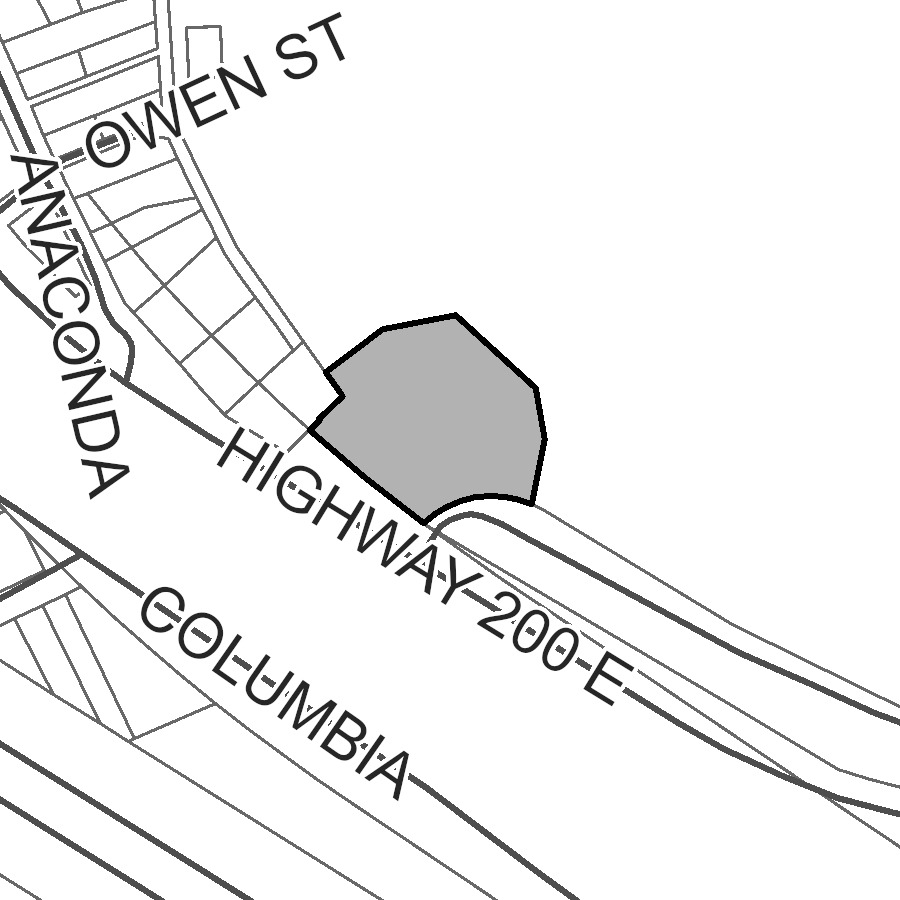
Titan Self Storage in Bonner - Special Exception and Variance Request
Share Titan Self Storage in Bonner - Special Exception and Variance Request on Facebook Share Titan Self Storage in Bonner - Special Exception and Variance Request on X (formerly Twitter) Share Titan Self Storage in Bonner - Special Exception and Variance Request on Linkedin Email Titan Self Storage in Bonner - Special Exception and Variance Request linkProject Description

Missoula County is seeking public input on a proposed special exception and variance request from Titan Self-Storage in Bonner to allow for construction of two additional storage buildings on the east side of the property.
The project is located at 7102 Hwy. 200 E., legally described as Lots 2-4 of Deed Exhibit 183 in S17, T13N, R18W, P.M.M.
Special Exception
A special exception is granted when a proposed use (in this case, adding more buildings to the existing storage facility) does not strictly meet requirements of the zoning district, but it meets design standards and conditions that make it consistent and compatible with existing uses in the district.
This property is zoned NC (Neighborhood Commercial), and the existing seven-building self-storage facility is a non-conforming use, meaning it met all zoning regulations that were in place at the time it was built, but it does not comply with current zoning. [CP1] [AF2] The Missoula County Zoning Regulations allow for expansion of non-conforming uses up to 50% if approved by the Board of Adjustment. The board will review the special exception to determine if the expansion will be compatible with adjacent land uses and is consistent and compatible with overall community character.
To approve the special exception, the board must determine:
- The proposed use or development will be compatible with and will not substantially injure the value of adjoining property;
- The proposed use preserves the character of the district, and the property is suitable for the use proposed.
When reviewing the application, the board will consider the following factors:
- Access, traffic and parking demand created by or impacted by the use, as well as pedestrian, bicycle, and onsite vehicular circulation.
- Dedication and development of streets, right-of-way and public use areas, such as sidewalks next to the property and the capacity to handle the use.
- Impacts on or of public and private utilities or services.
- Proposed siting of any new structures necessary to accommodate the use and their relationship to adjoining and surrounding properties.
- Recreation opportunities and open lands available to serve the use, if relevant.
- Natural resource protections.
- Area of land necessary and whether the site can adequately accommodate the use and meet the intent of the district and character of the neighborhood.
- Any other unique or relevant circumstances related to the property.
Variance
A variance is a relaxation of specific provisions of zoning regulations that can be granted when literal enforcement of would result in unnecessary or undue hardship.
The applicant is requesting a variance to construct the two new storage buildings outside of the required build-to zone, which is the area of a lot where a certain percentage of the front building facade must be located. This build-to zone requires the storage units to be located within 10 feet of the highway street-frontage. Instead, the applicant is seeking a variance so the buildings can be set back 35 to 40 feet from the highway, which would be consistent with prior development on the site. Otherwise, this proposal will meet all other zoning requirements of this district.
The Board of Adjustment may approve a zoning variance if it’s not contrary to the public interest where, owing to special conditions, a literal enforcement of the regulations will result in an unnecessary hardship. The board must consider the following criteria when evaluating a variance:
- The variance will not authorize a use that is not already allowed in the zoning district.
- The proposed variance will not authorize additional density beyond what is allowed in the zoning district.
- Special conditions exist that are unique to the property, such as size, shape, topography or location, that do not apply to other lands in the same zoning classification.
- Whether literal enforcement of the provisions of these regulations will result in unnecessary hardship that is not of the applicant’s own making.
- Granting the variance will be in harmony with the general purpose and intent of these regulations and the Missoula County Growth Policy and will not be injurious to the neighborhood or otherwise detrimental to the public welfare.
- The request for the variance is not based on monetary factor
Proposed Site Plan

Project Timeline
Board of Adjustment Public Hearing: Wednesday, July 16, 6 p.m.
Participants may attend the public hearing in person in the Sophie Moiese Room of the Missoula County Courthouse Annex, 200 West Broadway in Missoula. Participants may also attend the meeting virtually over Microsoft Teams by going to http://missoula.co/boardofadjustment. To join the call on your phone, call 406-272-4824, Conference ID 427 662 811#
This project is not subject to approval by the Board of County Commissioners.
Public Comment
Submit public comment using the comment tool below. Comments submitted by July 15 will be included in the packet for the Board of Adjustment meeting.
Project Lead
Jennie Dixon, 406-258-4946, jdixon@missoulacounty.us
Related Links and Documents
Titan Self Storage Application
-
Missoula County Floodplain Development Permit #25-22
Share Missoula County Floodplain Development Permit #25-22 on Facebook Share Missoula County Floodplain Development Permit #25-22 on X (formerly Twitter) Share Missoula County Floodplain Development Permit #25-22 on Linkedin Email Missoula County Floodplain Development Permit #25-22 link
Project Description:
The Missoula County Planning, Development & Sustainability Department (PDS) has received a floodplain development permit application from Joel Cusker for replacement of an open-sided pavilion in the Clark Fork River floodway.
The site is located 9499 Cusker Lane, on land just north of the Clark Fork & Bitterroot River confluence, in Section 27, Township 13 North, Range 20 West, Missoula County, P.M.M. View the site map here.
The full application is available for review in the PDS office at 127 E. Main St., Suite 2, in Missoula or online here. Written comments willContinue reading
 1 comment
Who's Listening
-

Phone 406-258-4794 -
Planner III/Floodplain Administrator
Missoula County Planning, Development and Sustainability

Phone 406-258-3799 -

Phone 406-258-4946 -

Phone 406-258-3425 -

Phone 406-258-3706 Email lryan@missoulacounty.us -

Phone 406-258-4841 -

Phone 406-258-4652 -

Phone 406-258-3707
Important Documents
-
 Shoreline Permit & Variance Application #25-06
-
 0 Cover letter.docx (22.5 KB) (docx)
-
1 County Shoreline Construction Permit.pdf (410 KB) (pdf)
-
2 DCI Engineering Shoreline Restoration letter.docx (203 KB) (docx)
-
3 County Shoreline Restoration Application Addendum.docx (46 KB) (docx)
-
4 Linford Colgan Vicinity Map.docx (257 KB) (docx)
-
5 Seeley Lake Shore Sites COS 53653.pdf (725 KB) (pdf)
-
6 Seeley Lake Shore Sites COS 53653 Enlarged.docx (316 KB) (docx)
-
7 Lots 78 80 82 Retracement COS 6242 2010.pdf (108 KB) (pdf)
-
8 Existing Conditions Photos.docx (1.22 MB) (docx)
-
9 Project Area Map.docx (1.17 MB) (docx)
-
10 MTNHWRD Map.docx (291 KB) (docx)
-
11 Site Plan Diagram.pdf (168 KB) (pdf)
-
12 Site Plan Cross Section Diagram.pdf (475 KB) (pdf)
-
13 Restoration Erosion Sed Runoff Plan Diagram.pdf (159 KB) (pdf)
-
14 Lakeside Interface Berm Diagram.pdf (166 KB) (pdf)
-
15 County Shoreline Permit Variance Request.docx (33.3 KB) (docx)
-
16 County Shoreline Restoration Application Project Impact Assessment.docx (52.5 KB) (docx)
-
2025_10_22 FACTS ACK_MTB013622_20062.PDF (179 KB) (PDF)
-
2025_10_22 FACTS APP_MTB013622_20062.PDF (309 KB) (PDF)
-
2025_10_29 FACTS permit AUTH_MTB013622_20062.PDF (192 KB) (PDF)
-
2026_01_05 cover letter for permit.pdf (429 KB) (pdf)
-
LUL Application Form .doc (128 KB) (doc)
-
navigable river license dnrc.pdf (1.94 MB) (pdf)
-
1 2021_NWP-13-FS_links.pdf (348 KB) (pdf)
-
1 20200219_SLOPES renewal_AppE_Conservation Measures.pdf (141 KB) (pdf)
-
1 Certification of Compliance.pdf (54.9 KB) (pdf)
-
1 Permit Verification.pdf (270 KB) (pdf)
-
1 SLOPES PROJECT COMPLETION REPORT FORM.docx (25.6 KB) (docx)
-
2026_05_20 404 permit update.docx (21.6 KB) (docx)
-
-
Blackfoot Crossing Project
-
01_Growth Policy Amendment Request2.0.pdf (739 KB) (pdf)
-
02_Zoning Amendment Application.pdf (317 KB) (pdf)
-
03_Existing Land Use.pdf (518 KB) (pdf)
-
04_Proposed Land Use.pdf (532 KB) (pdf)
-
05_Working Lands Land Use.pdf (383 KB) (pdf)
-
06_Open Resource and Recreation Land Use.pdf (383 KB) (pdf)
-
07_Neighborhood Center Land Use.pdf (368 KB) (pdf)
-
08_Commercial Center Land Use.pdf (350 KB) (pdf)
-
09_Industrial Center Land Use.pdf (353 KB) (pdf)
-
10_Heavy Industrial Center Land Use.pdf (361 KB) (pdf)
-
11_Existing Zoning.pdf (550 KB) (pdf)
-
12_Proposed Zoning.pdf (551 KB) (pdf)
-
13_Zoning Uses.pdf (190 KB) (pdf)
-
14_Aerial Topo.pdf (1.35 MB) (pdf)
-
15_Existing Conditions.pdf (907 KB) (pdf)
-
16_01 Legal Constraints.pdf (684 KB) (pdf)
-
17_WUI.pdf (186 KB) (pdf)
-
18_Slopes.pdf (5.65 MB) (pdf)
-
19_High Pressure Gas Lines.pdf (456 KB) (pdf)
-
20_utilities.pdf (581 KB) (pdf)
-
21_Earthquake Faults.pdf (2.12 MB) (pdf)
-
22_avalanche slope.pdf (1.15 MB) (pdf)
-
23_Hazardous Waste.pdf (435 KB) (pdf)
-
24_Healthcare Facilities.pdf (695 KB) (pdf)
-
25_Dam Failure.pdf (343 KB) (pdf)
-
26_Vegetation.pdf (1.51 MB) (pdf)
-
27_Flooplain.pdf (1.3 MB) (pdf)
-
28_Hydrology.pdf (740 KB) (pdf)
-
29_Wildlife Distribution.pdf (1.77 MB) (pdf)
-
30_Transportation.pdf (1.92 MB) (pdf)
-
31_Cultural Resource Inventory.pdf (6.87 MB) (pdf)
-
32_Soils Report.pdf (1.26 MB) (pdf)
-
33_Blackfoot Crossing 1 Subdivision.pdf (4.17 MB) (pdf)
-
34_Blackfoot Crossing 1 Sub Phasing Plan.pdf (345 KB) (pdf)
-
35_Blackfoot Riverfront Pplat.pdf (2.39 MB) (pdf)
-
36_ Riverfront Phasing.pdf (359 KB) (pdf)
-
37_Preliminary Stormwater Report.pdf (8 MB) (pdf)
-
38_Test Pits.pdf (159 KB) (pdf)
-
39_Well Logs.pdf (1.39 MB) (pdf)
-
40_02_Neighborhood Meeting Letter_Mtg 1.pdf (111 KB) (pdf)
-
40_04_PowerPoint Presentation_Mtg 1.pdf (9.6 MB) (pdf)
-
40_06_Neighborhood Meeting Summary_Mtg 1.pdf (130 KB) (pdf)
-
40_07_Neighborhood Comment_Mtg 1.pdf (715 KB) (pdf)
-
41_02_Neighborhood Meeting Letter_Mtg 2.pdf (118 KB) (pdf)
-
41_04_PowerPoint Presentation_Mtg 2.pdf (4.79 MB) (pdf)
-
41_05_Neighborhood Meeting Summary_Mtg 2.pdf (1000 KB) (pdf)
-
42_01_September 9 2025 Community Council Agenda.pdf (665 KB) (pdf)
-
42_02 Community Council Meeting Summary.pdf (39.4 KB) (pdf)
-
42_03_ Community Council Meeting Transcript.pdf (217 KB) (pdf)
-
42_04_Community Council Meeting Presentation.pdf (4.66 MB) (pdf)
-
42_05_Community Council Draft Meeting Minutes.pdf (706 KB) (pdf)
-
43_2009 Community Visioning Map.pdf (475 KB) (pdf)
-
44_2009 BMCC Meeting record (NEW 10.25).pdf (468 KB) (pdf)
-
45_Traffic Impact Study.pdf (22.4 MB) (pdf)
-
46_Tech Memo West Riverside Access Impacts.pdf (1.05 MB) (pdf)
-
BFXR Sub Rpt_FINAL.pdf (1.72 MB) (pdf)
-
Approved rezone.pdf (549 KB) (pdf)
-
Approved growth policy designation.pdf (532 KB) (pdf)
-
-
Brown Family Transfer
-
0 Cover Letter.pdf (50.8 KB) (pdf)
-
1 2023 Family Transfer Exemption Application and Affidavit.2023.Fillable.Form.pdf (1.17 MB) (pdf)
-
1.2 Signed Family Transfer Division of Land Affidavit.pdf (1.32 MB) (pdf)
-
1.5 Signed Landowner Letter.pdf (497 KB) (pdf)
-
1.7 WarrantyDeed.pdf (35.2 KB) (pdf)
-
2 Dinsmore IOrchard Homes 4 Lots 29 30bk17pg54.pdf (172 KB) (pdf)
-
4 Maps.docx (3.82 MB) (docx)
-
4.1 ZD-13 Franklin to Fort.pdf (1010 KB) (pdf)
-
4.2 ZD-13 resolution 2007-088.pdf (155 KB) (pdf)
-
4.3 FIRMETTE_f340b8a5-3b5a-4f36-91b2-7f1b330784f0.pdf (734 KB) (pdf)
-
5 Ditch Cards 3114 3110.pdf (434 KB) (pdf)
-
6 Septic Permit 2016-247.pdf (6.45 MB) (pdf)
-
7 3816 Brown-EXISTING.pdf (161 KB) (pdf)
-
7 3816 Brown-PROPOSED.pdf (170 KB) (pdf)
-
2026-01-20 Brown FT 400.pdf (447 KB) (pdf)
-
-
Grass Valley Farms
-
Review Criteria for Subdivision Requests (182 KB) (PNG)
-
Lolo Ranch Exemption Application (899 KB) (pdf)
-
Lolo Ranch Tract Information (56.5 KB) (pdf)
-
Lolo Ranch Existing and Proposed Parcels (684 KB) (pdf)
-
Spanish Skies Variance Request Application (7.45 MB) (pdf)
-
Frenchtown Storage — Buildings for Lease or Rent
-
Blackfoot Crossing Subdivision Phasing Plan Amendment and Plat Adjustment Application (13.2 MB) (pdf)
-
Floodplain Development Permit #25-12
-
Floodplain Development Permit #25-07
-
Floodplain Development Permit #25-15
-
Floodplain Development Permit #25-22
-
2025-05-12.SpecialExceptionVariance Application.pdf (29.9 MB) (pdf)
-
Lazy Acres Preliminary Plat Extension Request.pdf (314 KB) (pdf)
-
Floodplain Development #26-07
-
Floodplain Development #26-01
-
Floodplain Development #26-03
-
Floodplain Development #26-04
-
Floodplain Development #26-06
-
McAlister Family Transfer and Aggregation Exemption
-
Hertz Family Transfer Application
-
Floodplain Development #26-02
-
Floodplain Development 26-09.pdf (16.5 MB) (pdf)
-
Big Bear Addition Subdivision Amendment Proposal.pdf (1.51 MB) (pdf)
-
505 Highton Complete Application.pdf (2.43 MB) (pdf)
-
Schuff Family Transfer Application.pdf (6.81 MB) (pdf)
-
Stephenson Family Transfer Application
-
3614 Hwy 200 Special Exception Application
-
3507 S 7th St. W Special Exception
-
Floodplain Development #26-10
-
Ployhar Family Transfer.pdf (2.38 MB) (pdf)
-
Gilman Creek Road
-
Blackfoot Crossing Riverfront Public Notice.pdf (54.2 KB) (pdf)
-
Ram Addition- Minor Adjustment Application.pdf (4.06 MB) (pdf)
-
Hoyer Family Transfer Application.pdf (5.7 MB) (pdf)
-
Nordberg Family Transfer.pdf (5.41 MB) (pdf)
-
O'Keefe Ranch Estates Subdivision Landscaping Condition Amendment
-
Crawford Family Transfer Exemption Application.pdf (4.85 MB) (pdf)
-
Crawford Family Transfer Existing and Proposed Conditions.pdf (1.5 MB) (pdf)
-
Special Exception at 1815 Clements Rd. (Target Range)
-
2026-01-22 Granite Peak Phasing Ext App.pdf (1.49 MB) (pdf)
-
Ranch Club Subdivision Phasing Plan Extension
-
Larch Meadows Minor Subdivision
-
2026-03-06 Full Application.Missoula County.Larch Meadows (1).pdf (74.5 MB) (pdf)
-
Section A.pdf (836 KB) (pdf)
-
Section B.pdf (892 KB) (pdf)
-
Section C.pdf (1.51 MB) (pdf)
-
Section D.pdf (1.92 MB) (pdf)
-
Section E.pdf (22.7 MB) (pdf)
-
Section F.pdf (29.7 MB) (pdf)
-
Section G.pdf (15.5 MB) (pdf)
-
Section H.pdf (1.56 MB) (pdf)
-
Section I.pdf (1.91 MB) (pdf)
-
-
7985 Hwy. 200 E
-
County 310 Permit No. 26-01
-
Floodplain Development #26-05
-
Floodplain Development #26-08
-
Floodplain Development #26-12
-
Fire Bucket Meadows
-
Fire Bucket Meadows Application (73 MB) (pdf)
-
Fire Bucket Meadows Final Combined Groundwater Report (25.2 MB) (pdf)
-
Applicant Letter to COmmissioners 5-28-25.pdf (19 MB) (pdf)
-
Fire Bucket Loop Aquifer Test Work Plan.pdf (105 KB) (pdf)
-
Fire Bucket Meadows Subdivision Application.pdf (73 MB) (pdf)
-
Geosyntec Hydrologic Technical Analysis and Pump Test Results 1-22-26.pdf (7.88 MB) (pdf)
-
Photos of area homes (1).pdf (18.9 MB) (pdf)
-
Attachment D - Newman Hydrogeologist Report 5-22-26.pdf (153 KB) (pdf)
-
Pump Test Notice to Neighbors 10-13-25.pdf (315 KB) (pdf)
-
Sparks Well Log 9-17-25.pdf (830 KB) (pdf)
-
Water Quality Reports 11-25.pdf (1.19 MB) (pdf)
-
Water Rights Inc Letter 5-13.pdf (534 KB) (pdf)
-
Water Rights Inc. Review of Hydrogeologic Literature 5-5-25.pdf (25.2 MB) (pdf)
-
Willowstick Groundwater Well Siting Study 6-30-25.pdf (2.55 MB) (pdf)
-
Fire Bucket Meadows Form 633_2026.03.09.xlsx (738 KB) (xlsx)
-
Fire Bucket Layout 3-9-26.pdf (1000 KB) (pdf)
-
Water Quality District Comments 5-29-25.pdf (260 KB) (pdf)
-
Attachment O - Water Quality District Comments 5-12-25.pdf (205 KB) (pdf)
-
Attachment P - Water Quality District Comments 5-29-25.pdf (260 KB) (pdf)
-
Attachment Q - Water Quality District Presentation 5-29-25.pdf (31.2 MB) (pdf)
-
Attachment R - MPH Comments 5-22-25.pdf (3.91 MB) (pdf)
-
Attachment S - Amended Fire Bucket Prelim Plat 3-11-26.pdf (3.46 MB) (pdf)
-
Attachment T - Amended Fire Bucket Layout 3-11-26.pdf (930 KB) (pdf)
-
Attachment U - Final Amended Grading and Drainage Report 3-16-26.pdf (3.05 MB) (pdf)
-
Attachment V - Final Amended Preliminary Plat and Lot Layout 3-16-26.pdf (2.15 MB) (pdf)
-
-
Bowman Family Transfer Application
-
1716 Clements Road
-
3900 South Ave
-
Floodplain Development #26-14
-
Guilhemotonia Family Transfer
-
Hughes Family Transfer
-
Shelby Addition Plat Adjustment
-
Petty Creek Boundary Line Relocation
-
CZD 9 Accessory Structure Variance Request
-
Floodplain Development Permit #26-13
-
Floodplain Development Permit #26-16
-
6.1.26_Lolo Riverside Floodplain Permit App Attachments.pdf (13 MB) (pdf)
-
Duff Family Transfer

