Development Projects
Let us know your thoughts on private development projects happening in Missoula County.
Missoula County routinely considers development projects such as subdivisions, family transfers, boundary line relocations and rezoning requests. The projects featured on this page first come to the Planning, Development and Sustainability Department to ensure they meet various requirements related to zoning, land use, floodplain and other regulations. The Board of County Commissioners or the relevant decision-making body then considers approval of projects at their public meetings.
Comments on these projects help planning staff more accurately present to the commissioners how the community feels about the proposals, so the commissioners can make well-informed decisions on each project.
-
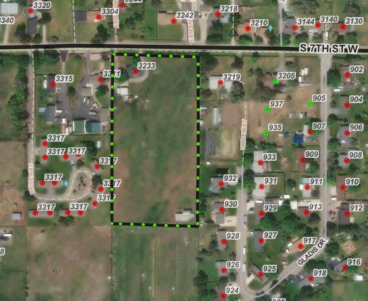
Stephenson Family Transfer Exemption
Share Stephenson Family Transfer Exemption on Facebook Share Stephenson Family Transfer Exemption on X (formerly Twitter) Share Stephenson Family Transfer Exemption on Linkedin Email Stephenson Family Transfer Exemption linkProject Description
Jeffrey Stephenson is requesting to use the family transfer exemption from subdivision review to divide their 4.5-acre property at 3233 S. 7th St. W. into two tracts (Lot 33-B: 3.85 acres; Lot 33-A: .87 acre). Stephenson plans to gift Lot 33-B to their spouse Wendy Grace and keep Lot 33-A as their primary residence. Jeffrey Stephenson and Wendy Grace will eventually move into a new house on Lot 33-B, while moving their aging parents into their current home on Lot 33-A.
Subdivision Regulations and Exemptions
Missoula County’s subdivision regulations promote public health, safety and general welfare by ensuring any subdivision of land in the County’s jurisdiction provides for adequate light, air, water supply, sewage disposal, parks and recreation areas, ingress and egress and other public requirements. Many requests to divide land must go through the subdivision process to ensure these requirements are met, but certain types of land division are exempt from subdivision review. Landowners can apply for one or multiple subdivision exemptions when their development plans meet the state and local requirements for the applicable exemptions.
Being granted these exemptions means the property owner does not need to go through the standard subdivision review process to divide their property. These requests require administrative review by planning staff and, in some cases, may require approval by the county commissioners to ensure the applicant is not evading these regulations.
-
Family Transfer Exemption
Landowners can request a family transfer exemption when they intend to divide their property to gift or sell the newly created parcel(s) to an immediate family member.
View subdivision exemption criteria.
What is a family transfer?
Montana law specifically allows landowners to divide land and gift or sell one parcel per immediate family member (like a child, parent or spouse), without full subdivision review.
Requests for family transfers must always come before the commissioners. Missoula County considers dozens of family land transfers every year. It’s not rare — other counties across Montana regularly process these applications too. It’s not a loophole — it’s in the law for a reason: to help families live near each other or pass down land. It’s does not skirt regulations — the process requires surveys, documentation, fees and approval by county commissioners.
The landowner and recipient must be real people, not LLCs or corporations. It can only be used once per family member per county.
Project Timeline
County commissioners hearing: Thursday, Nov. 6, 2 p.m.
- In-person location: Sophie Moiese Room, Missoula County Courthouse Annex, 200 West Broadway, Missoula
- Virtual option: Residents can attend the meeting via Microsoft Teams. To join the call on your phone, call 406-272-4824, Conference ID 467 457 758#. To join the meeting on your device, follow the links on the agenda that will be published at http://missoula.co/bccmeetings
Public Comment
Submit public comment by using the comment tool below.
Project Lead
Kevin Dantic, 406-258-4652, kdantic@missoulacounty.us
Important Links and Documents
Stephenson Family Transfer Application
-
Family Transfer Exemption
-
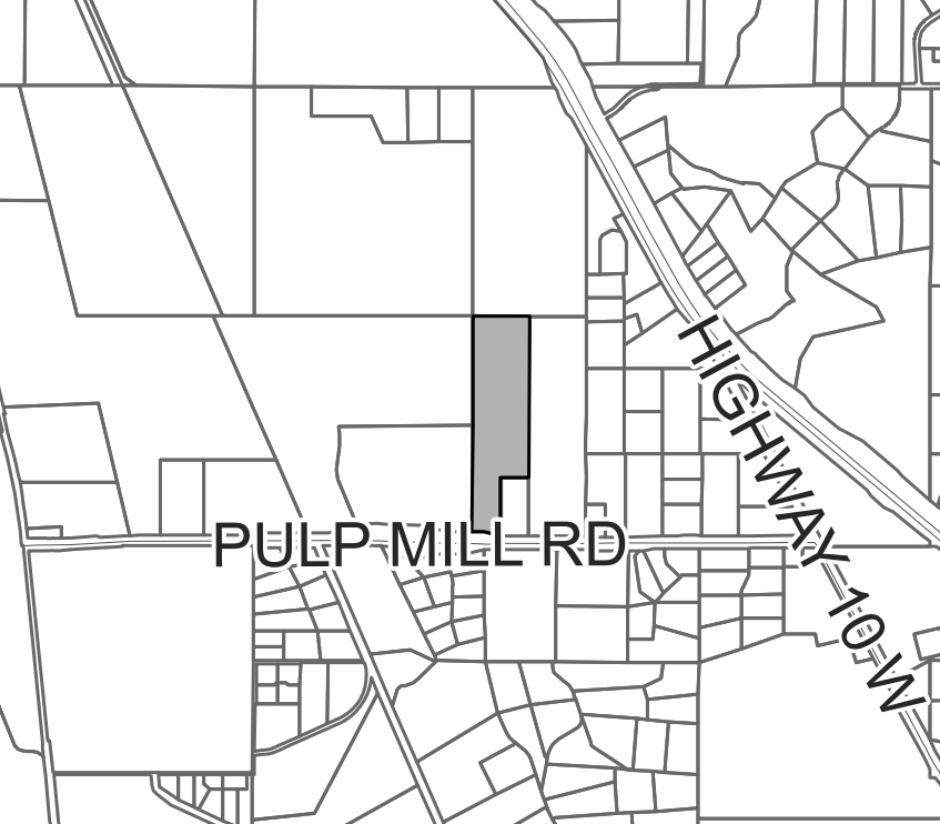
Big Bear Addition Subdivision Amendment (Wye)
Share Big Bear Addition Subdivision Amendment (Wye) on Facebook Share Big Bear Addition Subdivision Amendment (Wye) on X (formerly Twitter) Share Big Bear Addition Subdivision Amendment (Wye) on Linkedin Email Big Bear Addition Subdivision Amendment (Wye) linkProject description:
Dennis & Phyllis Sauter, represented by WGM Group, are requesting to amend Condition of Approval #3 and Development Covenant Section #3 for the Big Bear Addition Subdivision located at 12514 Pulp Mill Road in the Wye area.
The county commissioners originally approved of the Big Bear Addition Subdivision in 2003 with a final plat deadline in 2004, subject to three conditions of approval. The plat has since been filed.
The proposed amendment seeks to amend Condition of Approval #3 and Development Covenant Section #3, which state: “The landowner shall either install a 350 gpm well or sprinkler systems for any additional future structures or for expansions of the existing structures.” Instead of the 350 gpm well or sprinkler system, the amendment proposes to install a cistern and/or a dry hydrant system, as required by the Frenchtown Rural Fire Department and the county fire inspector for firefighting purposes of all new buildings and additions.
Project timeline:
County commissioners hearing: Thursday, Nov. 6, 2 p.m.
In-person location: Sophie Moiese Room, Missoula County Courthouse Annex, 200 West Broadway, Missoula
Virtual option: Residents can attend the meeting via Microsoft Teams. To join the call on your phone, call 406-272-4824, Conference ID 467 457 758#. To join the meeting on your device, follow the links on the agenda that will be published at http://missoula.co/bccmeetings.
Public comment:
Submit public comment by using the comment tool below.
Project lead:
Tim Worley, 406-258-4794, tworley@missoulacounty.us
Kevin Dantic, 406-258-4652, kdantic@missoulacounty.us
Related documents & links:
-
Floodplain Development No. 26-09
Share Floodplain Development No. 26-09 on Facebook Share Floodplain Development No. 26-09 on X (formerly Twitter) Share Floodplain Development No. 26-09 on Linkedin Email Floodplain Development No. 26-09 link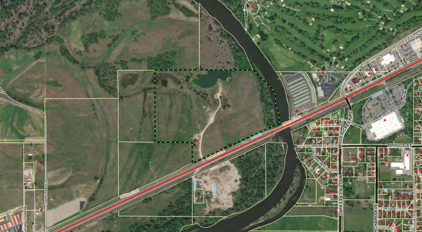
Project Description:
The Missoula County Planning, Development, & Sustainability (PDS) has received Floodplain Development Permit Application #26-09 from Jason Rice for improvements to an existing structure.
The primary purpose of a Floodplain Development Permit is to promote public health, safety and general welfare, to minimize flood losses in areas subject to flood hazards, and to promote wise use of the floodplain.

Project Location:
The site is located at 4285 Hwy. 93 S. in the Bitterroot River regulated flood hazard area: Section 01, Township 12 North, Range 20 West, Missoula County. See location here.
The full application is available for review online or in the PDS office at 127 E. Main St., Suite 2, in Missoula.
Please feel free to call 406-258-4657 or email floodplain@missoulacounty.us with any questions or to make an appointment to review the permit application.
Public Comment:
Submit comments by 5 p.m., Wednesday, Oct. 29, by using the comment tools below, by emailing floodplain@missoulacounty.us or mailing to Planning, Development, & Sustainability, Attn: Matt Heimel, Floodplain Administrator, 200 W. Broadway St., Missoula MT 59802.
Related Documents and Links:
This permit is subject to approval by the floodplain administrator and does not go before the Board of County Commissioners.
-
Floodplain Development No. 26-02
Share Floodplain Development No. 26-02 on Facebook Share Floodplain Development No. 26-02 on X (formerly Twitter) Share Floodplain Development No. 26-02 on Linkedin Email Floodplain Development No. 26-02 link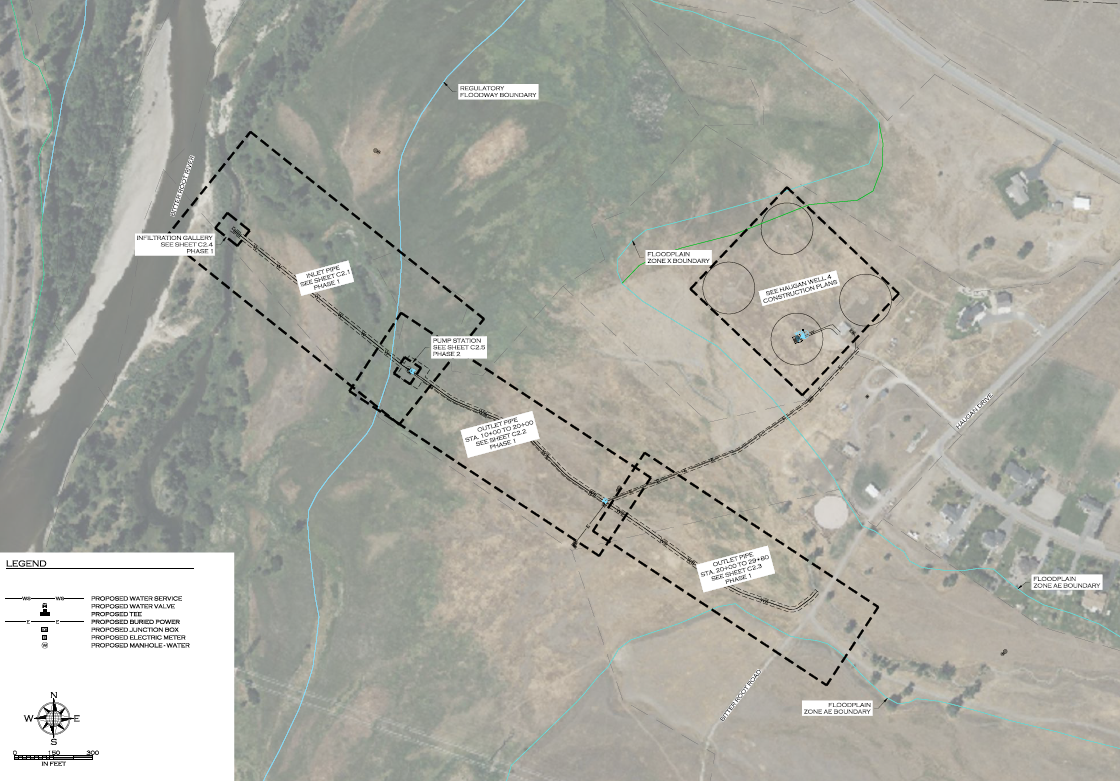
Project Description:
The Missoula County Planning, Development, & Sustainability (PDS) has received Floodplain Development Permit Application #26-02 from Tollefson Properties LLC for a new surface water diversion system in the Bitterroot River.
This permit application is the first of two phases of work. This first phase permit is for the construction of the diversion and preliminary installation of utilities. The second future phase and permit application will be for a pump structure and final utility work.
The primary purpose of a Floodplain Development Permit is to promote public health, safety, and general welfare, to minimize flood losses in areas subject to flood hazards, and to promote wise use of the floodplain.

Project Location:
The site is located at 6225 Haugan Drive and includes work in the Bitterroot River and Miller Creek regulated flood hazard area: Parcel 2 of COS 6484, Section 15, Township 12 North, Range 20 West and Parcel 2B of COS 6562, Section 14, Township 12 North, Range 20 West, Missoula County. See location here.
The full application is available for review online or in the PDS office at 127 E. Main St., Suite 2, in Missoula.
Please feel free to call 406-258-4657 or email floodplain@missoulacounty.us with any questions or to make an appointment to review the permit application.
Public Comment:
Submit comments by 5 p.m., Wednesday, Oct. 29, by using the comment tools below, by emailing floodplain@missoulacounty.us or mailing to Planning, Development, & Sustainability, Attn: Matt Heimel, Floodplain Administrator, 200 W. Broadway St., Missoula MT 59802.
Related Documents and Links:
Floodway Certification and Criteria Responses
This permit is subject to approval by the floodplain administrator and does not go before the Board of County Commissioners.
-
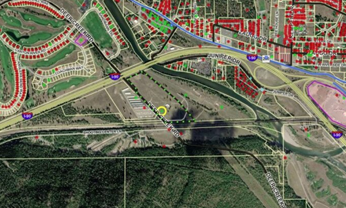
Wustner Minor Subdivision (East Missoula)
Share Wustner Minor Subdivision (East Missoula) on Facebook Share Wustner Minor Subdivision (East Missoula) on X (formerly Twitter) Share Wustner Minor Subdivision (East Missoula) on Linkedin Email Wustner Minor Subdivision (East Missoula) linkProject description:
The Wustner Minor Subdivision is a proposal by Bees 4 Ever, LLC, represented by IMEG Corporation, to subdivide 27.16 acres at 1005 Deer Creek Road in East Missoula into four lots. The site currently supports an agricultural building used for a bee pollination business, served by an exempt well and septic system. While the property is zoned agriculture and rural residential, the applicant does not anticipate residential development due to aspects of the surrounding area such as I-90, the railroad, a shooting range and storage units.
The subdivision design proposes four rectangular lots accessed from county-maintained Deer Creek Road, with no new public infrastructure proposed. Utilities will rely on exempt wells and septic systems, subject to Missoula Public Health Department approval. Covenants will address access, maintenance and limitations on residential use.
Project timeline:
County commissioners hearing: Thursday, Nov. 13, 2 p.m.
- In-person location: Sophie Moiese Room, Missoula County Courthouse Annex, 200 West Broadway, Missoula
- Virtual option: Residents can attend the meeting via Microsoft Teams. To join the call on your phone, call 406-272-4824, Conference ID 467 457 758#. To join the meeting on your device, follow the links on the agenda that will be published at http://missoula.co/bccmeetings(External link).
Public comment:
Submit public comment by using the comment tool below.
Project lead:
Katy Reeder, 406-258-3707, kreeder@missoulacounty.us
Related Documents & Links:
-
Hertz Family Transfer Exemption in Missoula
Share Hertz Family Transfer Exemption in Missoula on Facebook Share Hertz Family Transfer Exemption in Missoula on X (formerly Twitter) Share Hertz Family Transfer Exemption in Missoula on Linkedin Email Hertz Family Transfer Exemption in Missoula linkProject Description
Adam and Brittni Hertz are requesting to use the family transfer exemption from subdivision review to divide their 5.36-acre property at 10414 Royal Coachman Drive in Missoula into two tracts (Lot 2A: 4.29 acres; Lot 2B: 1.07 acres). They plan to gift their three daughters the 1.07 acre of land. When the daughters turn 18, Adam and Brittni will transfer both tracts of lands to their three daughters.

Subdivision Regulations and Exemptions
Missoula County’s subdivision regulations promote public health, safety and general welfare by ensuring any subdivision of land in the County’s jurisdiction provides for adequate light, air, water supply, sewage disposal, parks and recreation areas, ingress and egress and other public requirements. Many requests to divide land must go through the subdivision process to ensure these requirements are met, but certain types of land division are exempt from subdivision review. Landowners can apply for one or multiple subdivision exemptions when their development plans meet the state and local requirements for the applicable exemptions.
Being granted these exemptions means the property owner does not need to go through the standard subdivision review process to divide their property. These requests require administrative review by planning staff and, in some cases, may require approval by the county commissioners to ensure the applicant is not evading these regulations.
-
Family Transfer Exemption
Landowners can request a family transfer exemption when they intend to divide their property to gift or sell the newly created parcel(s) to an immediate family member.
View subdivision exemption criteria.
What is a family transfer?
Montana law specifically allows landowners to divide land and gift or sell one parcel per immediate family member (like a child, parent or spouse), without full subdivision review.
Requests for family transfers must always come before the commissioners. Missoula County considers dozens of family land transfers every year. It’s not rare — other counties across Montana regularly process these applications too. It’s not a loophole — it’s in the law for a reason: to help families live near each other or pass down land. It’s does not skirt regulations — the process requires surveys, documentation, fees and approval by county commissioners.
The landowner and recipient must be real people, not LLCs or corporations. It can only be used once per family member per county.
Project Timeline
Board of County Commissioners hearing: Thursday, Oct. 23, 2 p.m.
- In-person location: Sophie Moiese Room, Missoula County Courthouse Annex, 200 West Broadway, Missoula
- Virtual option: Residents can attend the meeting via Microsoft Teams. To join the call on your phone, call 406-272-4824, Conference ID 467 457 758#. To join the meeting on your device, follow the links on the agenda that will be published at http://missoula.co/bccmeetings(External link).
Public Comment
Submit public comment by using the comment tool below.
Project Lead
Katy Reeder, 406-258-3707, kreeder@missoulacounty.us
Important Links and Documents
-
Family Transfer Exemption
-
McAlister Family Transfer and Aggregation Exemption
Share McAlister Family Transfer and Aggregation Exemption on Facebook Share McAlister Family Transfer and Aggregation Exemption on X (formerly Twitter) Share McAlister Family Transfer and Aggregation Exemption on Linkedin Email McAlister Family Transfer and Aggregation Exemption linkProject Description:
James and Laurie McAlister are requesting to use the family transfer exemption to divide their 3.73-acre property at 3912 S 7th St. W. into three lots. They plan to gift two of these lots to their adult children, Caleb McAlister and Jessica (McAlister) Lewis, and keep the remaining lot.
- Tract 61A (1.44 acres) to Caleb McAlister
- Tract 61B (1.44 acres) to Jessica (McAlister) Lewis
- Tract 61C (1.11 acres) to be owned by James and Laurie McAlister

The McAlisters have also applied for an aggregation exemption from subdivision review to expunge a historic boundary line that was contained within the parent tract, which had been identified by the Missoula County Clerk and Recorder.Subdivision Regulations and Exemptions:
Missoula County’s subdivision regulations promote public health, safety and general welfare by ensuring any subdivision of land in the County’s jurisdiction provides for adequate light, air, water supply, sewage disposal, parks and recreation areas, ingress and egress and other public requirements. Many requests to divide land must go through the subdivision process to ensure these requirements are met, but certain types of land division are exempt from subdivision review. Landowners can apply for one or multiple subdivision exemptions when their development plans meet the state and local requirements for the applicable exemptions.
Being granted these exemptions means the property owner does not need to go through the standard subdivision review process to divide their property. These requests require administrative review by planning staff and, in some cases, may require approval by the county commissioners to ensure the applicant is not evading these regulations.
-
Family Transfer Exemption
Landowners can request a family transfer exemption when they intend to divide their property to gift or sell the newly created parcel(s) to an immediate family member. -
Aggregation Exemption
Landowners can request an aggregation exemption when the division or combination of parcels will not create new lots or otherwise significantly alter the development potential.
View subdivision exemption review criteria
ProjectTimeline
County Commissioners Hearing: Thursday, Oct. 23., 2 p.m.
- In-person location: Sophie Moiese Room, Missoula County Courthouse Annex, 200 West Broadway, Missoula
- Virtual option: Residents can attend the meeting via Microsoft Teams. To join the call on your phone, call 406-272-4824, Conference ID 467 457 758#. To join the meeting on your device, follow the links on the agenda that will be published at http://missoula.co/bccmeetings.
Public Comment:
Submit public comment using the comment tool below.
Project Lead:
Kevin Dantic, 406-258-4652, kdantic@missoulacounty.us
Related Links and Documents:
Existing and Proposed Conditions
Who's Listening
-

Phone 406-258-4794 -
Planner III/Floodplain Administrator
Missoula County Planning, Development and Sustainability

Phone 406-258-3799 -

Phone 406-258-4946 -
Phone 406-258-3425 -

Phone 406-258-3706 Email lryan@missoulacounty.us -

Phone 406-258-4841 -

Phone 406-258-4652 -

Phone 406-258-3707
Important Documents
-
 Shoreline Permit & Variance Application #25-06
-
 0 Cover letter.docx (22.5 KB) (docx)
-
1 County Shoreline Construction Permit.pdf (410 KB) (pdf)
-
2 DCI Engineering Shoreline Restoration letter.docx (203 KB) (docx)
-
3 County Shoreline Restoration Application Addendum.docx (46 KB) (docx)
-
4 Linford Colgan Vicinity Map.docx (257 KB) (docx)
-
5 Seeley Lake Shore Sites COS 53653.pdf (725 KB) (pdf)
-
6 Seeley Lake Shore Sites COS 53653 Enlarged.docx (316 KB) (docx)
-
7 Lots 78 80 82 Retracement COS 6242 2010.pdf (108 KB) (pdf)
-
8 Existing Conditions Photos.docx (1.22 MB) (docx)
-
9 Project Area Map.docx (1.17 MB) (docx)
-
10 MTNHWRD Map.docx (291 KB) (docx)
-
11 Site Plan Diagram.pdf (168 KB) (pdf)
-
12 Site Plan Cross Section Diagram.pdf (475 KB) (pdf)
-
13 Restoration Erosion Sed Runoff Plan Diagram.pdf (159 KB) (pdf)
-
14 Lakeside Interface Berm Diagram.pdf (166 KB) (pdf)
-
15 County Shoreline Permit Variance Request.docx (33.3 KB) (docx)
-
16 County Shoreline Restoration Application Project Impact Assessment.docx (52.5 KB) (docx)
-
2025_10_22 FACTS ACK_MTB013622_20062.PDF (179 KB) (PDF)
-
2025_10_22 FACTS APP_MTB013622_20062.PDF (309 KB) (PDF)
-
2025_10_29 FACTS permit AUTH_MTB013622_20062.PDF (192 KB) (PDF)
-
2026_01_05 cover letter for permit.pdf (429 KB) (pdf)
-
LUL Application Form .doc (128 KB) (doc)
-
navigable river license dnrc.pdf (1.94 MB) (pdf)
-
1 2021_NWP-13-FS_links.pdf (348 KB) (pdf)
-
1 20200219_SLOPES renewal_AppE_Conservation Measures.pdf (141 KB) (pdf)
-
1 Certification of Compliance.pdf (54.9 KB) (pdf)
-
1 Permit Verification.pdf (270 KB) (pdf)
-
1 SLOPES PROJECT COMPLETION REPORT FORM.docx (25.6 KB) (docx)
-
2026_05_20 404 permit update.docx (21.6 KB) (docx)
-
-
Blackfoot Crossing Project
-
01_Growth Policy Amendment Request2.0.pdf (739 KB) (pdf)
-
02_Zoning Amendment Application.pdf (317 KB) (pdf)
-
03_Existing Land Use.pdf (518 KB) (pdf)
-
04_Proposed Land Use.pdf (532 KB) (pdf)
-
05_Working Lands Land Use.pdf (383 KB) (pdf)
-
06_Open Resource and Recreation Land Use.pdf (383 KB) (pdf)
-
07_Neighborhood Center Land Use.pdf (368 KB) (pdf)
-
08_Commercial Center Land Use.pdf (350 KB) (pdf)
-
09_Industrial Center Land Use.pdf (353 KB) (pdf)
-
10_Heavy Industrial Center Land Use.pdf (361 KB) (pdf)
-
11_Existing Zoning.pdf (550 KB) (pdf)
-
12_Proposed Zoning.pdf (551 KB) (pdf)
-
13_Zoning Uses.pdf (190 KB) (pdf)
-
14_Aerial Topo.pdf (1.35 MB) (pdf)
-
15_Existing Conditions.pdf (907 KB) (pdf)
-
16_01 Legal Constraints.pdf (684 KB) (pdf)
-
17_WUI.pdf (186 KB) (pdf)
-
18_Slopes.pdf (5.65 MB) (pdf)
-
19_High Pressure Gas Lines.pdf (456 KB) (pdf)
-
20_utilities.pdf (581 KB) (pdf)
-
21_Earthquake Faults.pdf (2.12 MB) (pdf)
-
22_avalanche slope.pdf (1.15 MB) (pdf)
-
23_Hazardous Waste.pdf (435 KB) (pdf)
-
24_Healthcare Facilities.pdf (695 KB) (pdf)
-
25_Dam Failure.pdf (343 KB) (pdf)
-
26_Vegetation.pdf (1.51 MB) (pdf)
-
27_Flooplain.pdf (1.3 MB) (pdf)
-
28_Hydrology.pdf (740 KB) (pdf)
-
29_Wildlife Distribution.pdf (1.77 MB) (pdf)
-
30_Transportation.pdf (1.92 MB) (pdf)
-
31_Cultural Resource Inventory.pdf (6.87 MB) (pdf)
-
32_Soils Report.pdf (1.26 MB) (pdf)
-
33_Blackfoot Crossing 1 Subdivision.pdf (4.17 MB) (pdf)
-
34_Blackfoot Crossing 1 Sub Phasing Plan.pdf (345 KB) (pdf)
-
35_Blackfoot Riverfront Pplat.pdf (2.39 MB) (pdf)
-
36_ Riverfront Phasing.pdf (359 KB) (pdf)
-
37_Preliminary Stormwater Report.pdf (8 MB) (pdf)
-
38_Test Pits.pdf (159 KB) (pdf)
-
39_Well Logs.pdf (1.39 MB) (pdf)
-
40_02_Neighborhood Meeting Letter_Mtg 1.pdf (111 KB) (pdf)
-
40_04_PowerPoint Presentation_Mtg 1.pdf (9.6 MB) (pdf)
-
40_06_Neighborhood Meeting Summary_Mtg 1.pdf (130 KB) (pdf)
-
40_07_Neighborhood Comment_Mtg 1.pdf (715 KB) (pdf)
-
41_02_Neighborhood Meeting Letter_Mtg 2.pdf (118 KB) (pdf)
-
41_04_PowerPoint Presentation_Mtg 2.pdf (4.79 MB) (pdf)
-
41_05_Neighborhood Meeting Summary_Mtg 2.pdf (1000 KB) (pdf)
-
42_01_September 9 2025 Community Council Agenda.pdf (665 KB) (pdf)
-
42_02 Community Council Meeting Summary.pdf (39.4 KB) (pdf)
-
42_03_ Community Council Meeting Transcript.pdf (217 KB) (pdf)
-
42_04_Community Council Meeting Presentation.pdf (4.66 MB) (pdf)
-
42_05_Community Council Draft Meeting Minutes.pdf (706 KB) (pdf)
-
43_2009 Community Visioning Map.pdf (475 KB) (pdf)
-
44_2009 BMCC Meeting record (NEW 10.25).pdf (468 KB) (pdf)
-
45_Traffic Impact Study.pdf (22.4 MB) (pdf)
-
46_Tech Memo West Riverside Access Impacts.pdf (1.05 MB) (pdf)
-
BFXR Sub Rpt_FINAL.pdf (1.72 MB) (pdf)
-
Approved rezone.pdf (549 KB) (pdf)
-
Approved growth policy designation.pdf (532 KB) (pdf)
-
-
Brown Family Transfer
-
0 Cover Letter.pdf (50.8 KB) (pdf)
-
1 2023 Family Transfer Exemption Application and Affidavit.2023.Fillable.Form.pdf (1.17 MB) (pdf)
-
1.2 Signed Family Transfer Division of Land Affidavit.pdf (1.32 MB) (pdf)
-
1.5 Signed Landowner Letter.pdf (497 KB) (pdf)
-
1.7 WarrantyDeed.pdf (35.2 KB) (pdf)
-
2 Dinsmore IOrchard Homes 4 Lots 29 30bk17pg54.pdf (172 KB) (pdf)
-
4 Maps.docx (3.82 MB) (docx)
-
4.1 ZD-13 Franklin to Fort.pdf (1010 KB) (pdf)
-
4.2 ZD-13 resolution 2007-088.pdf (155 KB) (pdf)
-
4.3 FIRMETTE_f340b8a5-3b5a-4f36-91b2-7f1b330784f0.pdf (734 KB) (pdf)
-
5 Ditch Cards 3114 3110.pdf (434 KB) (pdf)
-
6 Septic Permit 2016-247.pdf (6.45 MB) (pdf)
-
7 3816 Brown-EXISTING.pdf (161 KB) (pdf)
-
7 3816 Brown-PROPOSED.pdf (170 KB) (pdf)
-
2026-01-20 Brown FT 400.pdf (447 KB) (pdf)
-
-
Grass Valley Farms
-
Review Criteria for Subdivision Requests (182 KB) (PNG)
-
Lolo Ranch Exemption Application (899 KB) (pdf)
-
Lolo Ranch Tract Information (56.5 KB) (pdf)
-
Lolo Ranch Existing and Proposed Parcels (684 KB) (pdf)
-
Spanish Skies Variance Request Application (7.45 MB) (pdf)
-
Frenchtown Storage — Buildings for Lease or Rent
-
Blackfoot Crossing Subdivision Phasing Plan Amendment and Plat Adjustment Application (13.2 MB) (pdf)
-
Floodplain Development Permit #25-12
-
Floodplain Development Permit #25-07
-
Floodplain Development Permit #25-15
-
Floodplain Development Permit #25-22
-
2025-05-12.SpecialExceptionVariance Application.pdf (29.9 MB) (pdf)
-
Lazy Acres Preliminary Plat Extension Request.pdf (314 KB) (pdf)
-
Floodplain Development #26-07
-
Floodplain Development #26-01
-
Floodplain Development #26-03
-
Floodplain Development #26-04
-
Floodplain Development #26-06
-
McAlister Family Transfer and Aggregation Exemption
-
Hertz Family Transfer Application
-
Floodplain Development #26-02
-
Floodplain Development 26-09.pdf (16.5 MB) (pdf)
-
Big Bear Addition Subdivision Amendment Proposal.pdf (1.51 MB) (pdf)
-
505 Highton Complete Application.pdf (2.43 MB) (pdf)
-
Schuff Family Transfer Application.pdf (6.81 MB) (pdf)
-
Stephenson Family Transfer Application
-
3614 Hwy 200 Special Exception Application
-
3507 S 7th St. W Special Exception
-
Floodplain Development #26-10
-
Ployhar Family Transfer.pdf (2.38 MB) (pdf)
-
Gilman Creek Road
-
Blackfoot Crossing Riverfront Public Notice.pdf (54.2 KB) (pdf)
-
Ram Addition- Minor Adjustment Application.pdf (4.06 MB) (pdf)
-
Hoyer Family Transfer Application.pdf (5.7 MB) (pdf)
-
Nordberg Family Transfer.pdf (5.41 MB) (pdf)
-
O'Keefe Ranch Estates Subdivision Landscaping Condition Amendment
-
Crawford Family Transfer Exemption Application.pdf (4.85 MB) (pdf)
-
Crawford Family Transfer Existing and Proposed Conditions.pdf (1.5 MB) (pdf)
-
Special Exception at 1815 Clements Rd. (Target Range)
-
2026-01-22 Granite Peak Phasing Ext App.pdf (1.49 MB) (pdf)
-
Ranch Club Subdivision Phasing Plan Extension
-
Larch Meadows Minor Subdivision
-
2026-03-06 Full Application.Missoula County.Larch Meadows (1).pdf (74.5 MB) (pdf)
-
Section A.pdf (836 KB) (pdf)
-
Section B.pdf (892 KB) (pdf)
-
Section C.pdf (1.51 MB) (pdf)
-
Section D.pdf (1.92 MB) (pdf)
-
Section E.pdf (22.7 MB) (pdf)
-
Section F.pdf (29.7 MB) (pdf)
-
Section G.pdf (15.5 MB) (pdf)
-
Section H.pdf (1.56 MB) (pdf)
-
Section I.pdf (1.91 MB) (pdf)
-
-
7985 Hwy. 200 E
-
County 310 Permit No. 26-01
-
Floodplain Development #26-05
-
Floodplain Development #26-08
-
Floodplain Development #26-12
-
Fire Bucket Meadows
-
Fire Bucket Meadows Application (73 MB) (pdf)
-
Fire Bucket Meadows Final Combined Groundwater Report (25.2 MB) (pdf)
-
Applicant Letter to COmmissioners 5-28-25.pdf (19 MB) (pdf)
-
Fire Bucket Loop Aquifer Test Work Plan.pdf (105 KB) (pdf)
-
Fire Bucket Meadows Subdivision Application.pdf (73 MB) (pdf)
-
Geosyntec Hydrologic Technical Analysis and Pump Test Results 1-22-26.pdf (7.88 MB) (pdf)
-
Photos of area homes (1).pdf (18.9 MB) (pdf)
-
Attachment D - Newman Hydrogeologist Report 5-22-26.pdf (153 KB) (pdf)
-
Pump Test Notice to Neighbors 10-13-25.pdf (315 KB) (pdf)
-
Sparks Well Log 9-17-25.pdf (830 KB) (pdf)
-
Water Quality Reports 11-25.pdf (1.19 MB) (pdf)
-
Water Rights Inc Letter 5-13.pdf (534 KB) (pdf)
-
Water Rights Inc. Review of Hydrogeologic Literature 5-5-25.pdf (25.2 MB) (pdf)
-
Willowstick Groundwater Well Siting Study 6-30-25.pdf (2.55 MB) (pdf)
-
Fire Bucket Meadows Form 633_2026.03.09.xlsx (738 KB) (xlsx)
-
Fire Bucket Layout 3-9-26.pdf (1000 KB) (pdf)
-
Water Quality District Comments 5-29-25.pdf (260 KB) (pdf)
-
Attachment O - Water Quality District Comments 5-12-25.pdf (205 KB) (pdf)
-
Attachment P - Water Quality District Comments 5-29-25.pdf (260 KB) (pdf)
-
Attachment Q - Water Quality District Presentation 5-29-25.pdf (31.2 MB) (pdf)
-
Attachment R - MPH Comments 5-22-25.pdf (3.91 MB) (pdf)
-
Attachment S - Amended Fire Bucket Prelim Plat 3-11-26.pdf (3.46 MB) (pdf)
-
Attachment T - Amended Fire Bucket Layout 3-11-26.pdf (930 KB) (pdf)
-
Attachment U - Final Amended Grading and Drainage Report 3-16-26.pdf (3.05 MB) (pdf)
-
Attachment V - Final Amended Preliminary Plat and Lot Layout 3-16-26.pdf (2.15 MB) (pdf)
-
-
Bowman Family Transfer Application
-
1716 Clements Road
-
3900 South Ave
-
Floodplain Development #26-14
-
Guilhemotonia Family Transfer
-
Hughes Family Transfer
-
Shelby Addition Plat Adjustment
-
Petty Creek Boundary Line Relocation
-
CZD 9 Accessory Structure Variance Request
-
Floodplain Development Permit #26-13
-
Floodplain Development Permit #26-16
-
6.1.26_Lolo Riverside Floodplain Permit App Attachments.pdf (13 MB) (pdf)
-
Duff Family Transfer

