Development Projects
Let us know your thoughts on private development projects happening in Missoula County.
Missoula County routinely considers development projects such as subdivisions, family transfers, boundary line relocations and rezoning requests. The projects featured on this page first come to the Planning, Development and Sustainability Department to ensure they meet various requirements related to zoning, land use, floodplain and other regulations. The Board of County Commissioners or the relevant decision-making body then considers approval of projects at their public meetings.
Comments on these projects help planning staff more accurately present to the commissioners how the community feels about the proposals, so the commissioners can make well-informed decisions on each project.
-
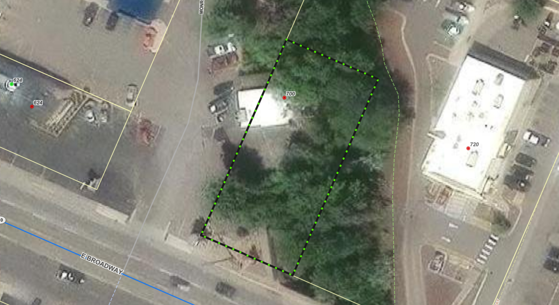
County 310 Permit No. 26-01
Share County 310 Permit No. 26-01 on Facebook Share County 310 Permit No. 26-01 on X (formerly Twitter) Share County 310 Permit No. 26-01 on Linkedin Email County 310 Permit No. 26-01 linkProject Description:
The Missoula County Planning, Development and Sustainability Department (PDS) has received a 310 Permit application from Clayton Moore to replace a deck and stairs for an existing structure and remove five trees next to Rattlesnake Creek. The site is located at 700 E Broadway next to the Rattlesnake Creek: Lots 6-10, Block 18, McWhirk Addition, S22, T13N, R19W in Missoula City limits.
What is a 310 permit?
A 310 permit is required for any projects that change natural flowing streams and rivers within Missoula City limits undertaken by a non-governmental body. This includes any work to the Clark Fork River and Rattlesnake Creek within city limits. Unlike a floodplain permit, 310 permits are overseen by county commissioners and not the floodplain administrator.
Click here for information about county 310 permitting.
Project Timeline:
County commissioners’ hearing: 2 p.m. Thursday, April 9
- In-person location: Sophie Moiese Room, Missoula County Courthouse Annex, 200 West Broadway, Missoula
- Virtual option: Residents can attend the meeting via Microsoft Teams. To join the call on your phone, call 406-272-4824, Conference ID 467 457 758#. To join the meeting on your device, follow the links on the agenda that will be published at http://missoula.co/bccmeetings
Public Comment:
Submit public comment by 5 p.m., Wednesday, April 8, through the following three ways.
- Use the comment tool below. You must be registered on Missoula County Voice
- Email floodplain@missoulacounty.us
- Mail to Planning, Development and Sustainability
- Attn: Matt Heimel, Floodplain Administrator, 200 W. Broadway St., Missoula, MT 59802
Questions or want to make an appointment?
Please feel free to call 406-258-4647 or email floodplain@missoulacounty.us with any questions or to make an appointment to review the permit application.
Important Documents and Links:
310 Permit Information Webpage
Physical applications are available in the PDS office at 127 E. Main St., Suite 2 in downtown Missoula
-
Sign Variance - 7985 Hwy. 200 E
Share Sign Variance - 7985 Hwy. 200 E on Facebook Share Sign Variance - 7985 Hwy. 200 E on X (formerly Twitter) Share Sign Variance - 7985 Hwy. 200 E on Linkedin Email Sign Variance - 7985 Hwy. 200 E linkThe Missoula County Consolidated Land Use Board (MCCLUB) held a public hearing for this request on March 4, 2026. During the public hearing, the applicants provided an amended sign plan that altered the design of the proposed wall signs and reduced the overall sign face area to 236.66 square feet. The amended sign plans are attached in the Important Links and Documents section of this page. At the March 4, 2026, meeting, the MCCLUB voted to approve the request for a variance from Section 8.8.O.1 Table 17, for the amended sign plans as presented at the meeting. The second variance request from Section 8.7.B Table 2, will be considered at the next MCCLUB meeting on April 1, 2026.
Missoula County Consolidated Land Use Board Meeting: Wednesday, April 1, 6 p.m.
· In-person location: 200 W. Broadway, Missoula County Courthouse, Sophie Moiese Room
· Virtual option: Residents can attend the meeting via Microsoft Teams. To join the meeting on your device, follow the links on the agenda that will be published on the Consolidated Land Use Board page.
Project Description:
Bonner 1 RE LLC is requesting a sign variance for their property at Bonner Town Pump Travel Plaza, located at 7985 Hwy. 200 E in Bonner.
The variance request is to accommodate the following changes:
- A variance to switch out five of the nine existing legal nonconforming signs. Current zoning regulations only permit four signs per project site.
- A variance to expand the total sign face area of the five new signs allowed in the CC zoning district. The five existing wall signs have a combined sign face area of 247 square feet, and the five proposed wall signs would have a combined sign face area of 317.83 square feet.

Project Background:
The existing nine signs on this property are currently legal nonconforming and were approved prior to current zoning regulations for this area. Legal nonconforming means that the signs are allowed to exist even though it does not conform with current regulations, with the understanding that any changes beyond normal maintenance and upkeep would require a variance from the Missoula County Consolidated Land Use Board.
Missoula County Sign Regulations:
What is a variance?
A variance is a relaxation of specific provisions of zoning regulations that can be granted if certain criteria can be met. The Consolidated Land Use Board may only approve a zoning variance if it’s not contrary to the public interest and does not give an advantage to a particular business that is not also enjoyed by other businesses in the same zoning district. They must evaluate proposed variances using the following criteria and find favorably that:
- The variance will not authorize a use that is not already allowed in the zoning district.
- The variance will not authorize additional density beyond what is allowed in the zoning district.
- Special conditions exist that are unique to the property, such as size, shape, topography or location, that do not apply to other lands in the same zoning classification.
- Literal enforcement of the provisions of the regulations will result in unnecessary hardship that is not of the applicant’s own making.
- Granting the variance will be in harmony with the general purpose and intent of these regulations and the Missoula County Growth Policy and will not be injurious to the neighborhood or otherwise detrimental to the public welfare.
- The request for the variance is not based on monetary factors.
Project Timeline:
Missoula County Consolidated Land Use Board Meeting: Wednesday, March 4, 6 p.m.
- In-person location: 200 W. Broadway, Missoula County Courthouse, Sophie Moiese Room
- Virtual option: Residents can attend the meeting via Microsoft Teams. To join the meeting on your device, follow the links on the agenda that will be published on the Consolidated Land Use Board page.
Missoula County Consolidated Land Use Board Meeting: Wednesday, April 1, 6 p.m.
· In-person location: 200 W. Broadway, Missoula County Courthouse, Sophie Moiese Room
· Virtual option: Residents can attend the meeting via Microsoft Teams. To join the meeting on your device, follow the links on the agenda that will be published on the Consolidated Land Use Board page.
Public Comment:
Submit public comment by Tuesday, March 3, by using the comment tool below.
Project Lead:
Patrick Swart, 406-258-4841
Important Links and Documents:
 1 comment
-
Granite Peak RV Resort Phasing Plan Extension
Share Granite Peak RV Resort Phasing Plan Extension on Facebook Share Granite Peak RV Resort Phasing Plan Extension on X (formerly Twitter) Share Granite Peak RV Resort Phasing Plan Extension on Linkedin Email Granite Peak RV Resort Phasing Plan Extension linkProject Description:
Granite Peak RV Resort, located at 9900 Thoroughbred Lane Missoula, is requesting an extension of the Phase 1 preliminary plat approval from August 2026 to August 2029 due to ongoing engineering work and pending agency approvals. This request does not affect the Phase 2 deadline. In 2024, the commissioners approved 50-space expansion of the existing RV park and received Special Exception approval after the property was rezoned to Neighborhood Residential. Construction for this project cannot begin until utility and infrastructure approvals are finalized.

Missoula County Subdivision Regulations Extension
Missoula County Subdivision Regulations (MCSR) Section 5.8.18.4 allows extension of at least one but no more than three years from the date of the request, which applies to the entire subdivision. Final plats for all phases of a subdivision approved on or after May 8, 2017, must be submitted to review and approved, conditionally approved or denied within 20 years of the date or preliminary plat approval (MCSR 5.8.19.5 B).
Project Timeline:
County commissioners’ public hearing: 2 p.m., Thursday, April 2
- In-person location: Sophie Moiese Room, Missoula County Courthouse Annex, 200 West Broadway, Missoula
- Virtual option: Residents can attend the meeting via Microsoft Teams. To join the call on your phone, call 406-272-4824, Conference ID 467 457 758#. To join the meeting on your device, follow the links on the agenda that will be published at http://missoula.co/bccmeetings
Public Comment:
Submit public comment by Wednesday, April 1, by using the comment tool below.
Project Lead:
Katy Reeder, kreeder@missoulacounty.us
Important Links and Documents:
Granite Peak Phasing Extension Application
Missoula County Subdivision Regulations
Former project: Granite Peak RV Park Extension in the Wye Application
-
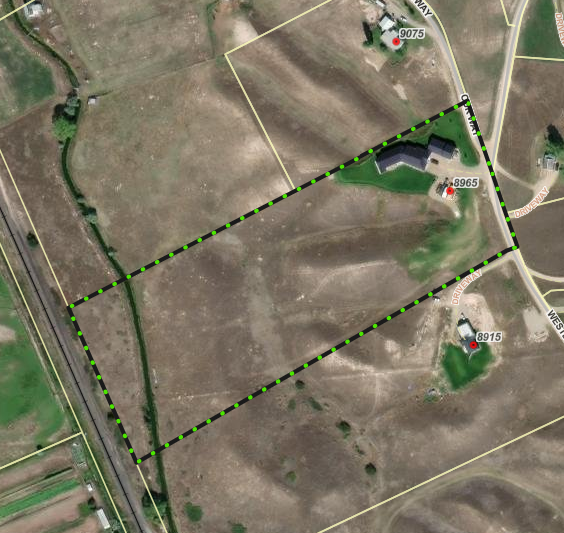
Crawford Family Transfer Exemption (Grass Valley Area)
Share Crawford Family Transfer Exemption (Grass Valley Area) on Facebook Share Crawford Family Transfer Exemption (Grass Valley Area) on X (formerly Twitter) Share Crawford Family Transfer Exemption (Grass Valley Area) on Linkedin Email Crawford Family Transfer Exemption (Grass Valley Area) linkProject Description:
Kristin L. Crawford is requesting to use the family transfer exemption from subdivision review to divide her current 11.9-acre parcel at 8965 Western Farms Road in Grass Valley Area into two parcels (Lot 9A-1: 6.60 acres; Lot 9A-2: 5 acres). Kristin plans to gift Lot 9A-2 to her father, Michael J. Robinson.
Subdivision Regulations and Exemptions
Missoula County’s subdivision regulations promote public health, safety and general welfare by ensuring any subdivision of land in the County’s jurisdiction provides for adequate light, air, water supply, sewage disposal, parks and recreation areas, ingress and egress and other public requirements. Many requests to divide land must go through the subdivision process to ensure these requirements are met, but certain types of land division are exempt from subdivision review. Landowners can apply for one or multiple subdivision exemptions when their development plans meet the state and local requirements for the applicable exemptions.
Being granted these exemptions means the property owner does not need to go through the standard subdivision review process to divide their property. These requests require administrative review by planning staff and, in some cases, may require approval by the county commissioners to ensure the applicant is not evading these regulations.
- Family Transfer Exemption
Landowners can request a family transfer exemption when they intend to divide their property to gift or sell the newly created parcel(s) to an immediate family member.
View subdivision exemption criteria.
What is a family transfer?
Montana law specifically allows landowners to divide land and gift or sell one parcel per immediate family member (like a child, parent or spouse), without full subdivision review.
Requests for family transfers must always come before the commissioners. Missoula County considers dozens of family land transfers every year. It’s not rare — other counties across Montana regularly process these applications too. It’s not a loophole — it’s in the law for a reason: to help families live near each other or pass down land. It does not skirt regulations — the process requires surveys, documentation, fees and approval by county commissioners.
The landowner and recipient must be real people, not LLCs or corporations. It can only be used once per family member per county.
Project Timeline:
County commissioners’ hearing: 2 p.m. Thursday, March 26
- In-person location: Sophie Moiese Room, Missoula County Courthouse Annex, 200 West Broadway, Missoula
- Virtual option: Residents can attend the meeting via Microsoft Teams. To join the call on your phone, call 406-272-4824, Conference ID 467 457 758#. To join the meeting on your device, follow the links on the agenda that will be published at http://missoula.co/bccmeetings
Public Comment:
Submit public comment by Wednesday, March 25, using the comment tool below.
Project Lead:
Kevin Dantic, 406-258-4652
Important Links and Documents:
Crawford Family Transfer Exemption Application
- Family Transfer Exemption
-
Fire Bucket Meadows Minor Subdivision
Share Fire Bucket Meadows Minor Subdivision on Facebook Share Fire Bucket Meadows Minor Subdivision on X (formerly Twitter) Share Fire Bucket Meadows Minor Subdivision on Linkedin Email Fire Bucket Meadows Minor Subdivision linkThe county commissioners will hold a public hearing to consider the Fire Bucket Meadows Minor Subdivision application on Thursday, March 26. This request was previously heard at public hearings on March 27, 2025, April 24, 2025, May 22, 2025, May 29, 2025, and June 26, 2025. At the request of the applicants during June 26, 2025, public hearing, the county commissioners voted to indefinitely postpone a decision on the proposed subdivision to allow the applicants to provide additional data and analysis of water quantity and quality and impacts to neighboring properties. The applicants have provided additional information relevant to the proposed subdivision which can be viewed in the attached included on this page. Please contact the Office of Planning, Development, and Sustainability with any questions.
Thursday, March 26, 2 p.m.: County Commissioners’ Public Meeting
- In-person location: 200 W. Broadway, Missoula County Courthouse, Sophie Moiese Room
- Virtual option: Residents can attend the meeting via Microsoft Teams. To join the meeting on your device, follow the links on the agenda that will be published on the Missoula County’s public meeting portal.
Project Description:
Fire Bucket Meadows Minor Subdivision is a proposed five-lot residential subdivision on 19.82 acres at 11109 Fire Bucket Loop, northwest of the Wye. The project is proposed by Dale Sparks and Tamara Jo Beich, represented by Professional Consultants Inc. Each lot will be accessed from Fire Bucket Loop, a 60-foot private access road. Road improvements are planned to bring the section serving the subdivision up to Missoula County road standards.
As part of the subdivision review process, we are seeking public comments on how the proposal aligns with key review criteria, including:
• Compliance with zoning and the Growth Policy
• Potential impacts on agriculture, local services, the natural environment, wildlife, and public health and safety
• Adherence to state survey requirements and local subdivision regulations
• Provision of necessary easements
• Availability of legal and physical access
Project Timeline:
Thursday, March 12, 2 p.m.: County Commissioners’ Public Meeting (Growth Policy Amendment, Rezoning, and Minor Subdivision)
- In-person location: 200 W. Broadway, Missoula County Courthouse, Sophie Moiese Room
- Virtual option: Residents can attend the meeting via Microsoft Teams. To join the meeting on your device, follow the links on the agenda that will be published on the Missoula County’s public meeting portal.
Public Comment:
Community members, especially adjacent property owners, are encouraged to submit comments and questions by commenting on this post, attend the meeting in person, or join virtually via Microsoft Teams.
Project Lead:
Patrick Swart, 406-258-4841
Important Links and Documents:
Related documents: Click here to download the application.
Applicant letter to commissioners
Fire Bucket meadows subdivision application
Geosyntec hydrologic technical analysis
Water District Quality Comments 5-9-25
Water Quality District Comments 5-12-25
Water Quality District Presentation 5-29-25
Water Quality District Presentation 5-29-25
Amended Fire Bucket Preliminary Plat 3-11-26
Amended Fire Bucket Layout 3-11-26
-
Floodplain Development No. 26-10
Share Floodplain Development No. 26-10 on Facebook Share Floodplain Development No. 26-10 on X (formerly Twitter) Share Floodplain Development No. 26-10 on Linkedin Email Floodplain Development No. 26-10 linkProject Description:
The Missoula County Planning, Development, & Sustainability Department (PDS) has received Floodplain Development Permit Application #26-10 from The Lamar Companies to replace the support structure of a current billboard sign.
The primary purpose of a Floodplain Development Permit is to promote health, safety and general welfare, minimize flood losses in areas subject to flood hazards and promote wise use of the floodplain.

Project Location:
The site is located at 904 U North Reserve St. in the Clark Fork River regulated flood hazard area: southwest end of the Reserve Street bridge, Section 17, Township 13 North, Range 196 West, Missoula County.
The full application is available for review online or in the PDS office at 127 E. Main St., Suite 2, in Missoula.
Please feel free to call 406-258-4647 or email floodplain@missoulacounty.us with any questions or to make an appointment to review the permit application.
Public Comment:
Submit comments by 5 p.m. Monday, Nov. 24 by using the comment tool below, emailing floodplain@missoulacounty.us or mailing to Planning, Development, & Sustainability, Attn: Matt Heimel, Floodplain Administrator, 200 W. Broadway St., Missoula MT 59802
Related Documents and Links:
Missoula County Floodplain and Shoreline Administration
This permit is subject to approval by the floodplain administrator and does not go before the Board of County Commissioners.
-
TS Overlook Minor Subdivision (Grass Valley)
Share TS Overlook Minor Subdivision (Grass Valley) on Facebook Share TS Overlook Minor Subdivision (Grass Valley) on X (formerly Twitter) Share TS Overlook Minor Subdivision (Grass Valley) on Linkedin Email TS Overlook Minor Subdivision (Grass Valley) linkThe public hearing meeting for this project has been changed to Thursday, March 12.
Project DescriptionThis is a request from Trent and Sally Jo Looker, represented by Ken E. Jenkins of Montana Northwest Company, to subdivide a 24.57-acre parcel at 9501 Western Farms Road in the Grass Valley Area into three lots. The site is bordered by Pulp Mill Road on the north and Western Farms Road on the east, which is located about two miles northwest of the Wye off Highway 10 West.

The property consists of non-irrigated dryland pasture grasses on rolling hills. The property is not significant agricultural land; it is already partially developed with no agricultural irrigation. A narrow strip of riparian resource exists along O’Keefe Creek, on proposed Lot C, which is already developed with the applicant’s existing single-family home. This narrow natural area along O’Keefe Creek is protected by a “No Build, No Development Zone.” The subject property is outside of the FEMA mapped floodplain. The property was created in 1977 as one of five 20-acre tracts, recorded as Certificate of Survey 1319.Western Farms Road is the existing county-maintained gravel road proposed that would serve Lots 1-3, with two additional approaches and driveways to be constructed for Lots 1 & 2. The subdivision is in the urban fringe, Missoula-Frenchtown area, surrounded by existing subdivisions, agriculture and single-family homes. The Frenchtown Rural Fire District serves the area, and children will attend Frenchtown schools.
Subdivision Regulations
Missoula County’s subdivision regulations(External link) promote public health, safety and general welfare by ensuring any subdivision of land in the County’s jurisdiction provides for adequate light, air, water supply, sewage disposal, parks and recreation areas, ingress and egress and other public requirements. A subdivision is considered “minor” when it has five or fewer lots.
Staff consider the following when making a recommendation to the county commissioners on whether to approve or deny a subdivision request:
compliance with zoning and the Growth Policy
effects on agriculture and agricultural water user facilities, local services, the natural environment, wildlife, and wildlife habitat and public health and safety
compliance with survey requirements established in state statute, and local subdivision regulations and review procedures
provision of necessary easements and other legal and physical access
Project Timeline:
County commissioners hearing: Thursday, March 12, 2 p.m.
In-person location: Sophie Moiese Room, Missoula County Courthouse Annex, 200 West Broadway, Missoula
Virtual option: Residents can attend the meeting via Microsoft Teams. To join the call on your phone, call 406-272-4824, Conference ID 467 457 758#. To join the meeting on your device, follow the links on the agenda that will be published at http://missoula.co/bccmeetings
Public Comment:
Submit public comment by using the comment tool below.
Project Lead:
Katy Reeder (click here to email)
Important Links and Documents:
-
Special Exception Request at 1815 Clements Road (Target Range)
Share Special Exception Request at 1815 Clements Road (Target Range) on Facebook Share Special Exception Request at 1815 Clements Road (Target Range) on X (formerly Twitter) Share Special Exception Request at 1815 Clements Road (Target Range) on Linkedin Email Special Exception Request at 1815 Clements Road (Target Range) linkJune and Larry Dvorak are requesting a special exception to have multiple principal-uses for their property at 1815 Clements Rd. in the Target Range neighborhood.

The property is currently zoned Rural Residential, Small Agriculture (RRS) .5, which allows rural residential development along with the preservation of natural landscape and small- scale agricultural land uses. Only one residential unit is allowed per lot in this district.
The Dvoraks are requesting a special exception so they can place a new modular home on the property for June’s daughter, Casey Nixon. The property is currently developed with a detached dwelling, a mobile home, a detached garage, a barn and two sheds.
Missoula County Zoning Regulations allow for multiple principal-uses on lots in this zoning district if a special exception is approved.
The applicants have already received approval from the county commissioners in June 2025, to create a 0.68-acre family transfer parcel to accommodate the proposed residential structure. The applicants cannot create the family transfer parcel until they receive approval from the Montana Department of Environmental Quality (DEQ), which can take several months. The Dvoraks are pursuing the special exception to allow them to go through the permit review for the new structure prior to the creation of the family transfer parcel.
Special Exception Information:
The Board of Adjustment is authorized to grant special exception permits authorizing a use established as eligible in this district, but this requires a special degree of consideration and control to ensure such uses are consistent and compatible with the overall community character. To approve a special exception, the board must determine:
- The proposed use or development will be compatible with and will not substantially injure the value of adjoining property.
- The proposed use preserves the character of the district, and the property is suitable for the use proposed.
- The proposed use promotes the purpose and intent of the TIF Special District, where applicable. (Not applicable for this project.)
- Substitute or additional design standards will preserve and protect the area’s architectural and aesthetic qualities.
In reviewing a special exception application, the board shall give due consideration to the following factors in determining if the use is appropriate:
- Access, traffic and parking demand created by or impacted by the use, and pedestrian, bicycle and onsite vehicular circulation.
- Dedication and development of streets, right-of-way, and public use areas, such as sidewalks adjoining the property and the capacity to handle the use.
- Impacts on or of public and private utilities or services.
- Proposed siting of any new structures necessary to accommodate the use and their relationship to adjoining and surrounding properties.
- Recreation opportunities and open lands available to serve the use.
- Natural resource protections.
- Landscaping and screening requirements.
- Signage and sign lighting, as applicable.
- Noise, vibration, outdoor lighting, and other on- and off-site impacts resulting from the use.
- Frequency of use and hours of operation.
- Area of land necessary and adequacy of the site to accommodate the use and meet the intent of the district and character of the neighborhood.
- Any other unique or relevant circumstances related to the property.
Project Timeline:
Missoula County Consolidated Land Use Board meeting: 6 p.m. Wednesday, Feb. 18.
- In-person location: Sophie Moiese Room, Missoula County Courthouse Annex, 200 West Broadway, Missoula
- Virtual option: Residents can attend the meeting via Microsoft Teams. To join the call on your phone, call 406-272-4824, Conference ID 115 075 404#. To join the meeting on your device, follow the links on the agenda that will be published at http://missoula.co/mcclubmeetings.
Public Comment:
Submit public comment by Tuesday, Feb. 17, using the comment tool below.
Project Lead:
Patrick Swart, 406-258-4841
Important Links and Documents:
-
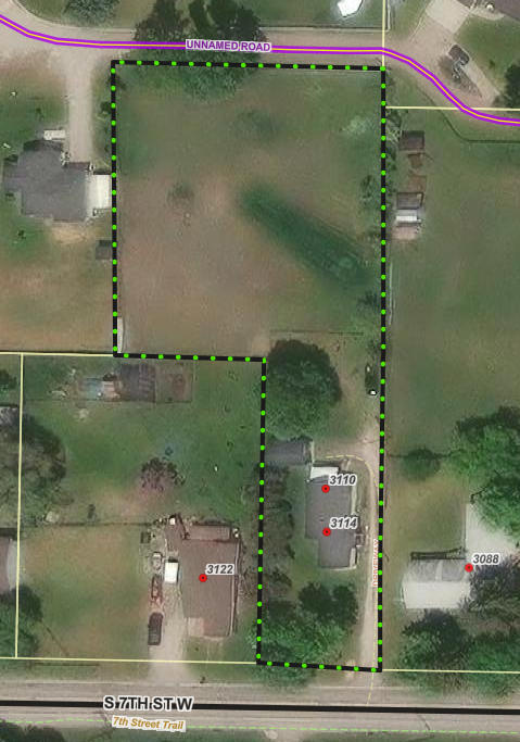
Brown Family Transfer Exemption (Orchard Homes)
Share Brown Family Transfer Exemption (Orchard Homes) on Facebook Share Brown Family Transfer Exemption (Orchard Homes) on X (formerly Twitter) Share Brown Family Transfer Exemption (Orchard Homes) on Linkedin Email Brown Family Transfer Exemption (Orchard Homes) linkProject Description:
Leta M. Brown is requesting to use the family transfer exemption from subdivision review to divide their 1-acre property located at 3114 S. 7th Street W. into two tracts (Lot A: 0.31-acres; Lot B: 0.69 acres). Leta plans to gift Lot B to her daughter, Megan A. Brown, and keep Lot A as her primary residence.
Subdivision Regulations and Exemptions
Missoula County’s subdivision regulations promote public health, safety and general welfare by ensuring any subdivision of land in the County’s jurisdiction provides for adequate light, air, water supply, sewage disposal, parks and recreation areas, ingress and egress and other public requirements. Many requests to divide land must go through the subdivision process to ensure these requirements are met, but certain types of land division are exempt from subdivision review. Landowners can apply for one or multiple subdivision exemptions when their development plans meet the state and local requirements for the applicable exemptions.
Being granted these exemptions means the property owner does not need to go through the standard subdivision review process to divide their property. These requests require administrative review by planning staff and, in some cases, may require approval by the county commissioners to ensure the applicant is not evading these regulations.
- Family Transfer Exemption
Landowners can request a family transfer exemption when they intend to divide their property to gift or sell the newly created parcel(s) to an immediate family member.
View subdivision exemption criteria.
What is a family transfer?
Montana law specifically allows landowners to divide land and gift or sell one parcel per immediate family member (like a child, parent or spouse), without full subdivision review.
Requests for family transfers must always come before the commissioners. Missoula County considers dozens of family land transfers every year. It’s not rare — other counties across Montana regularly process these applications too. It’s not a loophole — it’s in the law for a reason: to help families live near each other or pass down land. It does not skirt regulations — the process requires surveys, documentation, fees and approval by county commissioners.
The landowner and recipient must be real people, not LLCs or corporations. It can only be used once per family member per county.
Project Timeline:
County commissioners’ hearing: 2 p.m. Thursday, Feb. 12
- In-person location: Sophie Moiese Room, Missoula County Courthouse Annex, 200 West Broadway, Missoula
- Virtual option: Residents can attend the meeting via Microsoft Teams. To join the call on your phone, call 406-272-4824, Conference ID 467 457 758#. To join the meeting on your device, follow the links on the agenda that will be published at http://missoula.co/bccmeetings
Public Comment:
Submit public comment by using the comment tool below.
Project Lead:
Katy Reeder; kreeder@missoulacounty.us
Important Links and Documents:
Brown Family Transfer Exemption Application
Supporting Documents
- Look under important documents in the Brown Family Transfer folder
- Family Transfer Exemption
-
Kobos Family Transfer Exemption (Target Range)
Share Kobos Family Transfer Exemption (Target Range) on Facebook Share Kobos Family Transfer Exemption (Target Range) on X (formerly Twitter) Share Kobos Family Transfer Exemption (Target Range) on Linkedin Email Kobos Family Transfer Exemption (Target Range) linkProject Description
Mark Kobos is requesting to use the family transfer exemption from subdivision review to divide his current 2.45-acre property at 1015 Humble Road in Target Range into two parcels. Mark plans to gift a 1.38-acre parcel to his daughter, Emily Alsbury, and keep the remaining 1.07-acre parcel as his primary residence.
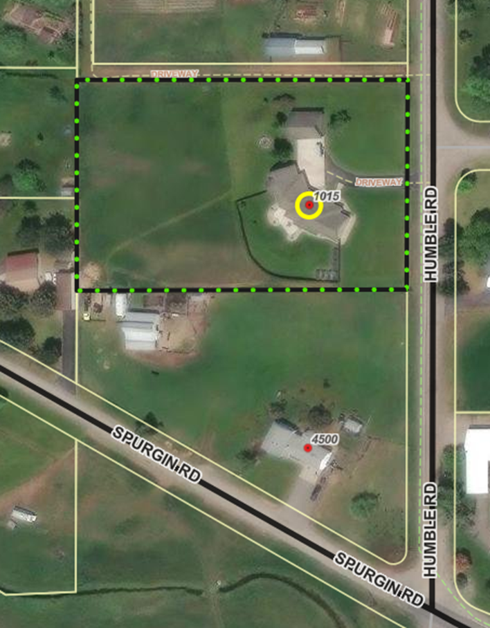
The property is zoned RRS 1, which allows a maximum of one home/acre, and is classified as Rural Residential and Small Agriculture by the 2019 Missoula Area Land Use Element. The parcel is also located within the boundaries of the 2010 Target Range Neighborhood Plan, which provides for transitional low density residential uses between urbanized areas and agricultural uses. It also provides a zone that may be used to meet residential needs while limiting density to recognize environmental concerns.
Subdivision Regulations and Exemptions
Missoula County’s subdivision regulations promote public health, safety and general welfare by ensuring any subdivision of land in the County’s jurisdiction provides for adequate light, air, water supply, sewage disposal, parks and recreation areas, ingress and egress and other public requirements. Many requests to divide land must go through the subdivision process to ensure these requirements are met, but certain types of land division are exempt from subdivision review. Landowners can apply for one or multiple subdivision exemptions when their development plans meet the state and local requirements for the applicable exemptions.
Being granted these exemptions means the property owner does not need to go through the standard subdivision review process to divide their property. These requests require administrative review by planning staff and, in some cases, may require approval by the county commissioners to ensure the applicant is not evading these regulations.
Family Transfer Exemption
Landowners can request a family transfer exemption when they intend to divide their property to gift or sell the newly created parcel(s) to an immediate family member.
What is a family transfer?
Montana law specifically allows landowners to divide land and gift or sell one parcel per immediate family member (like a child, parent or spouse), without full subdivision review.
Requests for family transfers must always come before the commissioners. Missoula County considers dozens of family land transfers every year. It’s not rare — other counties across Montana regularly process these applications too. It’s not a loophole — it’s in the law for a reason: to help families live near each other or pass down land. It does not skirt regulations — the process requires surveys, documentation, fees and approval by county commissioners.
The landowner and recipient must be real people, not LLCs or corporations. It can only be used once per family member per county.
Project Timeline:
County commissioners hearing: Thursday, Feb. 5, 2 p.m.
In-person location: Sophie Moiese Room, Missoula County Courthouse Annex, 200 West Broadway, Missoula
Virtual option: Residents can attend the meeting via Microsoft Teams. To join the call on your phone, call 406-272-4824, Conference ID 467 457 758#. To join the meeting on your device, follow the links on the agenda that will be published at http://missoula.co/bccmeetings
Public Comment:
Submit public comment by using the comment tool below.
Project Lead:
Kevin Dantic (click to email)
Important Links and Documents:
 1 comment
Who's Listening
-

Phone 406-258-4794 -
Planner III/Floodplain Administrator
Missoula County Planning, Development and Sustainability

Phone 406-258-3799 -

Phone 406-258-4946 -
Phone 406-258-3425 -

Phone 406-258-3706 Email lryan@missoulacounty.us -

Phone 406-258-4841 -

Phone 406-258-4652 -

Phone 406-258-3707
Important Documents
-
 Shoreline Permit & Variance Application #25-06
-
 0 Cover letter.docx (22.5 KB) (docx)
-
1 County Shoreline Construction Permit.pdf (410 KB) (pdf)
-
2 DCI Engineering Shoreline Restoration letter.docx (203 KB) (docx)
-
3 County Shoreline Restoration Application Addendum.docx (46 KB) (docx)
-
4 Linford Colgan Vicinity Map.docx (257 KB) (docx)
-
5 Seeley Lake Shore Sites COS 53653.pdf (725 KB) (pdf)
-
6 Seeley Lake Shore Sites COS 53653 Enlarged.docx (316 KB) (docx)
-
7 Lots 78 80 82 Retracement COS 6242 2010.pdf (108 KB) (pdf)
-
8 Existing Conditions Photos.docx (1.22 MB) (docx)
-
9 Project Area Map.docx (1.17 MB) (docx)
-
10 MTNHWRD Map.docx (291 KB) (docx)
-
11 Site Plan Diagram.pdf (168 KB) (pdf)
-
12 Site Plan Cross Section Diagram.pdf (475 KB) (pdf)
-
13 Restoration Erosion Sed Runoff Plan Diagram.pdf (159 KB) (pdf)
-
14 Lakeside Interface Berm Diagram.pdf (166 KB) (pdf)
-
15 County Shoreline Permit Variance Request.docx (33.3 KB) (docx)
-
16 County Shoreline Restoration Application Project Impact Assessment.docx (52.5 KB) (docx)
-
2025_10_22 FACTS ACK_MTB013622_20062.PDF (179 KB) (PDF)
-
2025_10_22 FACTS APP_MTB013622_20062.PDF (309 KB) (PDF)
-
2025_10_29 FACTS permit AUTH_MTB013622_20062.PDF (192 KB) (PDF)
-
2026_01_05 cover letter for permit.pdf (429 KB) (pdf)
-
LUL Application Form .doc (128 KB) (doc)
-
navigable river license dnrc.pdf (1.94 MB) (pdf)
-
1 2021_NWP-13-FS_links.pdf (348 KB) (pdf)
-
1 20200219_SLOPES renewal_AppE_Conservation Measures.pdf (141 KB) (pdf)
-
1 Certification of Compliance.pdf (54.9 KB) (pdf)
-
1 Permit Verification.pdf (270 KB) (pdf)
-
1 SLOPES PROJECT COMPLETION REPORT FORM.docx (25.6 KB) (docx)
-
2026_05_20 404 permit update.docx (21.6 KB) (docx)
-
-
Blackfoot Crossing Project
-
01_Growth Policy Amendment Request2.0.pdf (739 KB) (pdf)
-
02_Zoning Amendment Application.pdf (317 KB) (pdf)
-
03_Existing Land Use.pdf (518 KB) (pdf)
-
04_Proposed Land Use.pdf (532 KB) (pdf)
-
05_Working Lands Land Use.pdf (383 KB) (pdf)
-
06_Open Resource and Recreation Land Use.pdf (383 KB) (pdf)
-
07_Neighborhood Center Land Use.pdf (368 KB) (pdf)
-
08_Commercial Center Land Use.pdf (350 KB) (pdf)
-
09_Industrial Center Land Use.pdf (353 KB) (pdf)
-
10_Heavy Industrial Center Land Use.pdf (361 KB) (pdf)
-
11_Existing Zoning.pdf (550 KB) (pdf)
-
12_Proposed Zoning.pdf (551 KB) (pdf)
-
13_Zoning Uses.pdf (190 KB) (pdf)
-
14_Aerial Topo.pdf (1.35 MB) (pdf)
-
15_Existing Conditions.pdf (907 KB) (pdf)
-
16_01 Legal Constraints.pdf (684 KB) (pdf)
-
17_WUI.pdf (186 KB) (pdf)
-
18_Slopes.pdf (5.65 MB) (pdf)
-
19_High Pressure Gas Lines.pdf (456 KB) (pdf)
-
20_utilities.pdf (581 KB) (pdf)
-
21_Earthquake Faults.pdf (2.12 MB) (pdf)
-
22_avalanche slope.pdf (1.15 MB) (pdf)
-
23_Hazardous Waste.pdf (435 KB) (pdf)
-
24_Healthcare Facilities.pdf (695 KB) (pdf)
-
25_Dam Failure.pdf (343 KB) (pdf)
-
26_Vegetation.pdf (1.51 MB) (pdf)
-
27_Flooplain.pdf (1.3 MB) (pdf)
-
28_Hydrology.pdf (740 KB) (pdf)
-
29_Wildlife Distribution.pdf (1.77 MB) (pdf)
-
30_Transportation.pdf (1.92 MB) (pdf)
-
31_Cultural Resource Inventory.pdf (6.87 MB) (pdf)
-
32_Soils Report.pdf (1.26 MB) (pdf)
-
33_Blackfoot Crossing 1 Subdivision.pdf (4.17 MB) (pdf)
-
34_Blackfoot Crossing 1 Sub Phasing Plan.pdf (345 KB) (pdf)
-
35_Blackfoot Riverfront Pplat.pdf (2.39 MB) (pdf)
-
36_ Riverfront Phasing.pdf (359 KB) (pdf)
-
37_Preliminary Stormwater Report.pdf (8 MB) (pdf)
-
38_Test Pits.pdf (159 KB) (pdf)
-
39_Well Logs.pdf (1.39 MB) (pdf)
-
40_02_Neighborhood Meeting Letter_Mtg 1.pdf (111 KB) (pdf)
-
40_04_PowerPoint Presentation_Mtg 1.pdf (9.6 MB) (pdf)
-
40_06_Neighborhood Meeting Summary_Mtg 1.pdf (130 KB) (pdf)
-
40_07_Neighborhood Comment_Mtg 1.pdf (715 KB) (pdf)
-
41_02_Neighborhood Meeting Letter_Mtg 2.pdf (118 KB) (pdf)
-
41_04_PowerPoint Presentation_Mtg 2.pdf (4.79 MB) (pdf)
-
41_05_Neighborhood Meeting Summary_Mtg 2.pdf (1000 KB) (pdf)
-
42_01_September 9 2025 Community Council Agenda.pdf (665 KB) (pdf)
-
42_02 Community Council Meeting Summary.pdf (39.4 KB) (pdf)
-
42_03_ Community Council Meeting Transcript.pdf (217 KB) (pdf)
-
42_04_Community Council Meeting Presentation.pdf (4.66 MB) (pdf)
-
42_05_Community Council Draft Meeting Minutes.pdf (706 KB) (pdf)
-
43_2009 Community Visioning Map.pdf (475 KB) (pdf)
-
44_2009 BMCC Meeting record (NEW 10.25).pdf (468 KB) (pdf)
-
45_Traffic Impact Study.pdf (22.4 MB) (pdf)
-
46_Tech Memo West Riverside Access Impacts.pdf (1.05 MB) (pdf)
-
BFXR Sub Rpt_FINAL.pdf (1.72 MB) (pdf)
-
Approved rezone.pdf (549 KB) (pdf)
-
Approved growth policy designation.pdf (532 KB) (pdf)
-
-
Brown Family Transfer
-
0 Cover Letter.pdf (50.8 KB) (pdf)
-
1 2023 Family Transfer Exemption Application and Affidavit.2023.Fillable.Form.pdf (1.17 MB) (pdf)
-
1.2 Signed Family Transfer Division of Land Affidavit.pdf (1.32 MB) (pdf)
-
1.5 Signed Landowner Letter.pdf (497 KB) (pdf)
-
1.7 WarrantyDeed.pdf (35.2 KB) (pdf)
-
2 Dinsmore IOrchard Homes 4 Lots 29 30bk17pg54.pdf (172 KB) (pdf)
-
4 Maps.docx (3.82 MB) (docx)
-
4.1 ZD-13 Franklin to Fort.pdf (1010 KB) (pdf)
-
4.2 ZD-13 resolution 2007-088.pdf (155 KB) (pdf)
-
4.3 FIRMETTE_f340b8a5-3b5a-4f36-91b2-7f1b330784f0.pdf (734 KB) (pdf)
-
5 Ditch Cards 3114 3110.pdf (434 KB) (pdf)
-
6 Septic Permit 2016-247.pdf (6.45 MB) (pdf)
-
7 3816 Brown-EXISTING.pdf (161 KB) (pdf)
-
7 3816 Brown-PROPOSED.pdf (170 KB) (pdf)
-
2026-01-20 Brown FT 400.pdf (447 KB) (pdf)
-
-
Grass Valley Farms
-
Review Criteria for Subdivision Requests (182 KB) (PNG)
-
Lolo Ranch Exemption Application (899 KB) (pdf)
-
Lolo Ranch Tract Information (56.5 KB) (pdf)
-
Lolo Ranch Existing and Proposed Parcels (684 KB) (pdf)
-
Spanish Skies Variance Request Application (7.45 MB) (pdf)
-
Frenchtown Storage — Buildings for Lease or Rent
-
Blackfoot Crossing Subdivision Phasing Plan Amendment and Plat Adjustment Application (13.2 MB) (pdf)
-
Floodplain Development Permit #25-12
-
Floodplain Development Permit #25-07
-
Floodplain Development Permit #25-15
-
Floodplain Development Permit #25-22
-
2025-05-12.SpecialExceptionVariance Application.pdf (29.9 MB) (pdf)
-
Lazy Acres Preliminary Plat Extension Request.pdf (314 KB) (pdf)
-
Floodplain Development #26-07
-
Floodplain Development #26-01
-
Floodplain Development #26-03
-
Floodplain Development #26-04
-
Floodplain Development #26-06
-
McAlister Family Transfer and Aggregation Exemption
-
Hertz Family Transfer Application
-
Floodplain Development #26-02
-
Floodplain Development 26-09.pdf (16.5 MB) (pdf)
-
Big Bear Addition Subdivision Amendment Proposal.pdf (1.51 MB) (pdf)
-
505 Highton Complete Application.pdf (2.43 MB) (pdf)
-
Schuff Family Transfer Application.pdf (6.81 MB) (pdf)
-
Stephenson Family Transfer Application
-
3614 Hwy 200 Special Exception Application
-
3507 S 7th St. W Special Exception
-
Floodplain Development #26-10
-
Ployhar Family Transfer.pdf (2.38 MB) (pdf)
-
Gilman Creek Road
-
Blackfoot Crossing Riverfront Public Notice.pdf (54.2 KB) (pdf)
-
Ram Addition- Minor Adjustment Application.pdf (4.06 MB) (pdf)
-
Hoyer Family Transfer Application.pdf (5.7 MB) (pdf)
-
Nordberg Family Transfer.pdf (5.41 MB) (pdf)
-
O'Keefe Ranch Estates Subdivision Landscaping Condition Amendment
-
Crawford Family Transfer Exemption Application.pdf (4.85 MB) (pdf)
-
Crawford Family Transfer Existing and Proposed Conditions.pdf (1.5 MB) (pdf)
-
Special Exception at 1815 Clements Rd. (Target Range)
-
2026-01-22 Granite Peak Phasing Ext App.pdf (1.49 MB) (pdf)
-
Ranch Club Subdivision Phasing Plan Extension
-
Larch Meadows Minor Subdivision
-
2026-03-06 Full Application.Missoula County.Larch Meadows (1).pdf (74.5 MB) (pdf)
-
Section A.pdf (836 KB) (pdf)
-
Section B.pdf (892 KB) (pdf)
-
Section C.pdf (1.51 MB) (pdf)
-
Section D.pdf (1.92 MB) (pdf)
-
Section E.pdf (22.7 MB) (pdf)
-
Section F.pdf (29.7 MB) (pdf)
-
Section G.pdf (15.5 MB) (pdf)
-
Section H.pdf (1.56 MB) (pdf)
-
Section I.pdf (1.91 MB) (pdf)
-
-
7985 Hwy. 200 E
-
County 310 Permit No. 26-01
-
Floodplain Development #26-05
-
Floodplain Development #26-08
-
Floodplain Development #26-12
-
Fire Bucket Meadows
-
Fire Bucket Meadows Application (73 MB) (pdf)
-
Fire Bucket Meadows Final Combined Groundwater Report (25.2 MB) (pdf)
-
Applicant Letter to COmmissioners 5-28-25.pdf (19 MB) (pdf)
-
Fire Bucket Loop Aquifer Test Work Plan.pdf (105 KB) (pdf)
-
Fire Bucket Meadows Subdivision Application.pdf (73 MB) (pdf)
-
Geosyntec Hydrologic Technical Analysis and Pump Test Results 1-22-26.pdf (7.88 MB) (pdf)
-
Photos of area homes (1).pdf (18.9 MB) (pdf)
-
Attachment D - Newman Hydrogeologist Report 5-22-26.pdf (153 KB) (pdf)
-
Pump Test Notice to Neighbors 10-13-25.pdf (315 KB) (pdf)
-
Sparks Well Log 9-17-25.pdf (830 KB) (pdf)
-
Water Quality Reports 11-25.pdf (1.19 MB) (pdf)
-
Water Rights Inc Letter 5-13.pdf (534 KB) (pdf)
-
Water Rights Inc. Review of Hydrogeologic Literature 5-5-25.pdf (25.2 MB) (pdf)
-
Willowstick Groundwater Well Siting Study 6-30-25.pdf (2.55 MB) (pdf)
-
Fire Bucket Meadows Form 633_2026.03.09.xlsx (738 KB) (xlsx)
-
Fire Bucket Layout 3-9-26.pdf (1000 KB) (pdf)
-
Water Quality District Comments 5-29-25.pdf (260 KB) (pdf)
-
Attachment O - Water Quality District Comments 5-12-25.pdf (205 KB) (pdf)
-
Attachment P - Water Quality District Comments 5-29-25.pdf (260 KB) (pdf)
-
Attachment Q - Water Quality District Presentation 5-29-25.pdf (31.2 MB) (pdf)
-
Attachment R - MPH Comments 5-22-25.pdf (3.91 MB) (pdf)
-
Attachment S - Amended Fire Bucket Prelim Plat 3-11-26.pdf (3.46 MB) (pdf)
-
Attachment T - Amended Fire Bucket Layout 3-11-26.pdf (930 KB) (pdf)
-
Attachment U - Final Amended Grading and Drainage Report 3-16-26.pdf (3.05 MB) (pdf)
-
Attachment V - Final Amended Preliminary Plat and Lot Layout 3-16-26.pdf (2.15 MB) (pdf)
-
-
Bowman Family Transfer Application
-
1716 Clements Road
-
3900 South Ave
-
Floodplain Development #26-14
-
Guilhemotonia Family Transfer
-
Hughes Family Transfer
-
Shelby Addition Plat Adjustment
-
Petty Creek Boundary Line Relocation
-
CZD 9 Accessory Structure Variance Request
-
Floodplain Development Permit #26-13
-
Floodplain Development Permit #26-16
-
6.1.26_Lolo Riverside Floodplain Permit App Attachments.pdf (13 MB) (pdf)
-
Duff Family Transfer

